|
Strategy and Infrastructure Committee - 6 March 2018 - Attachments
|
Item 1 Attachments a |
Strategy and Infrastructure Committee
|
Meeting Date: |
Tuesday 6 March 2018 |
|
Time: |
3pm |
|
Venue: |
Council Chambers |
|
Committee Members |
Mayor Dalton, Councillor Price (In the Chair), Councillors Boag, Brosnan, Dallimore, Hague, Jeffery, McGrath, Tapine, Taylor, White, Wise and Wright |
|
Officers Responsible |
Director City Strategy, Director City Infrastructure |
|
Administration |
Governance Team |
|
|
Next Strategy and Infrastructure Committee Meeting Tuesday 17 April 2018 |
Strategy and Infrastructure Committee - 06 March 2018 - Open Agenda
ORDER OF BUSINESS
Apologies
Nil
Conflicts of interest
Public forum
Vanessa Moon and Christine Cairns speaking to Item 3 - Traffic Safety Improvements – Jervoistown.
Announcements by the Mayor
Announcements by the Chairperson
Announcements by the management
Confirmation of minutes
That the Minutes of the Strategy and Infrastructure Committee meeting held on Tuesday, 30 January 2018 be taken as a true and accurate record of the meeting – page 34 refers.
Notification and justification of matters of extraordinary business
(Strictly for information and/or referral purposes only).
Agenda items
1 Name of the Conference Centre Building........................................................................ 3
2 Coastal Hazards Strategy............................................................................................... 9
3 Traffic Safety Improvements - Jervoistown.................................................................... 21
4 20 & 21 Chambers Street, land legalisation - land to be declared road.......................... 28
Public excluded ............................................................................................................. 32
Strategy and Infrastructure Committee - 06 March 2018 - Open Agenda Item 1
1. Name of the Conference Centre Building
|
Type of Report: |
Procedural |
|
Legal Reference: |
N/A |
|
Document ID: |
449068 |
|
Reporting Officer/s & Unit: |
Charles Ropitini, Strategic Māori Advisor Antoinette Campbell, Director Community Services |
1.1 Purpose of Report
To consider the name of the Napier Conference Centre building.
|
That Council a. Rename the conference centre building to War Memorial Napier Conference Centre. |
|
That the Council a. Discuss the proposed renaming of the conference centre building. |
1.2 Background Summary
The original War Memorial Hall was built by public subscription in memory of those who lost their lives in the Second World War.
The original memorial was located on the outside of the War Memorial Hall and consisted of a perpetual flame, a water feature, and a Roll of Honour. In 1995, the building had significant renovations in order to provide a conference centre for Napier and the subsequent expansion enclosed the memorial elements within the new and larger building structure.
In 2015, Napier City Council approved a redevelopment project for the facility that included seismic strengthening, an extension, and an upgrade of the building to make it more suited for medium-sized national and international conferences and events.
During the design phase it was recognised that having the War Memorial inside the facility was restrictive both for public access alongside the appropriateness of its location in an area used for social events. It was also identified that the name, War Memorial Conference Centre, had created marketing issues, particularly with potential Australian clients.
At its ordinary meeting of 29th June 2016, the Council subsequently resolved to:
“Change the name of the Napier War Memorial Conference Centre to the Napier Conference Centre with the tag line of Conferences / Events / Functions.”
The decision to relocate the War Memorial and Roll of Honour has since been met with disapproval from some members of the community. Although the report to Council was presented in a public meeting, it is apparent that there was little wider community awareness of the change. There has also been some concern raised with the name change of the War Memorial Conference Centre to Napier Conference Centre.
Following public consultation, and at its meeting of 27th September 2017, Council resolved to;
“Agree that community consultation is undertaken on the future of the existing Roll of Honour plaques, the design concepts and the name of the centre.”
This report addresses the name of the facility only. The design concept and criteria for the Roll of Honour will be presented to Council at a later date.
1.3 Issues
In January 2018, three public meetings were held to provide an update on the War Memorial project and to consult on the Roll of Honour naming criteria.
While the public meetings were successful in canvassing opinion on the Roll of Honour review, the meetings raised the issue of the name of the Napier Conference Centre with a push for the reinstatement of the War Memorial title to the building.
The decision to change the name of the facility was based on the following reasons:
1. The name had evolved as War Memorial elements had been removed from the building and the building has had significant change to its original form and purpose, both in 1995 and in again in 2015;
2. An Australasian brand and marketing specialist confirmed that there was confusion about the facility being an RSL (Australian equivalent of RSA), and this had been stated as a reason for not progressing booking enquiries.
3. Both Taradale and Napier RSA organisations were consulted and supported the decision at that time.
The three public meetings held last month have indicated the significance of the reinstatement of the War Memorial title to the Napier Conference Centre to parts of the community. A number of variations on the name of the centre have been put forward with the two most popular being;
1. Retain the Napier Conference Centre name of the facility and name the original 1957 hall (the ballroom) the “War Memorial Hall”
2. Rename the Napier Conference Centre facility to the “War Memorial: Napier Conference Centre”.
These options are to be assessed against the status quo.
1.4 Significance and Consultation
This project is a priority for Council and has had ongoing consultation with the community. In total four public meetings have been held to date and both councillors and a section of the community have expressed their thoughts and suggestions around the name.
Council officers will schedule a further public meeting to update the community on the following elements:
· An update on the final War Memorial design concept
· A presentation on the criteria for the Roll of Honour and ensuing research project.
1.5 Implications
Financial
If Council makes the decision to reinstate the title of the War Memorial into Napier Conference Centre facility, the financial implications are expected to be in the following areas:
Brand
A review of the current brand visual identity will need to be undertaken, with professional advice sought to ensure integrity is maintained for the inclusion of the War Memorial title to the facility. The activity delivered from the facility will continue to be that of conferences, events and functions delivery and will therefore need not to be rebranded. It is only the building structure that is proposed to be rebranded with appropriate signage affixed to the building.
Marketing
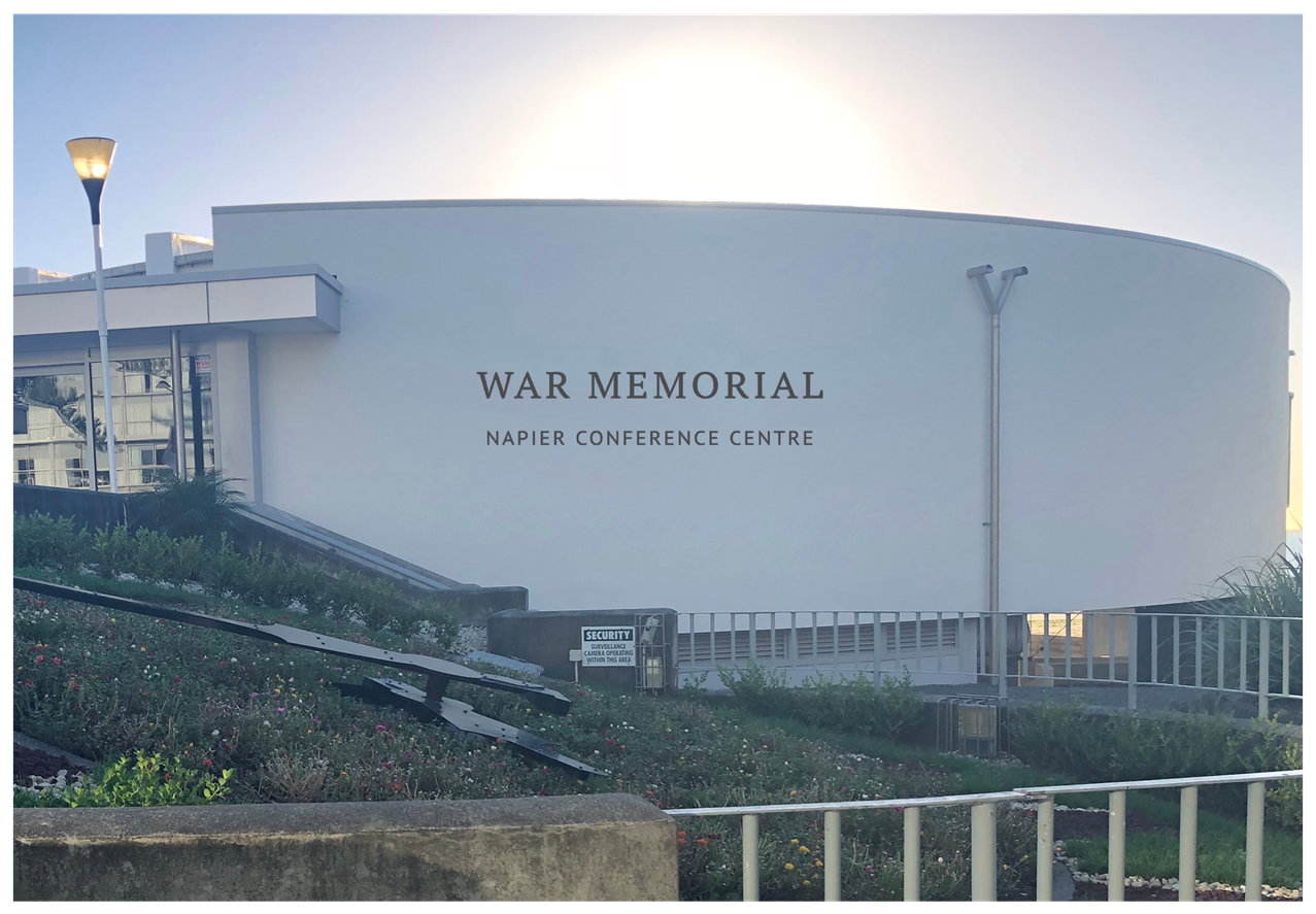
It is proposed that the activity continues to be marketed as the Napier Conference Centre, and the facility is branded on the outside to include the War Memorial title, proximal to where the memorial will be reinstated (a mock-up of the proposed branding is shown at Attachment A).
It is estimated that the cost of undertaking a complete branding change including that of the marketing and promotion collateral, would be approximately $100,000. With the proposal to rebrand the facility only to include War Memorial title, this cost would be considerably lower. There is no financial provision for a branding change however if kept to a minimum as proposed, could be reallocated from existing budget.
Social & Policy
N/A
Risk
N/A
1.6 Options
The options available to Council are as follows:
a. Retain the Napier Conference Centre name of the facility and name the original 1957 hall (the ballroom) the “War Memorial Hall”
b. Rename the Napier Conference Centre facility to the “War Memorial Napier Conference Centre”
c. Maintain the status quo.
1.7 Development of Preferred Option
The preferred option is that the conference centre building be renamed, and branded, War Memorial Napier Conference Centre. In consulting with the community, this has been clearly identified as the preferred option with the reinstatement of the words ‘War Memorial’ to the building in its entirety. This will provide for the building structure to display prominent branding and signage that clearly denotes that it is indeed a war memorial.
The existing branding of the activity delivered from the centre can be maintained so as not to cause confusion with the purpose of the facility, and to attract a wide conference, events and functions audience, as is the purpose of the activity.
a Artist's Impression of Proposed Branding ⇩
|
Type of Report: |
Operational |
|
Legal Reference: |
N/A |
|
Document ID: |
449684 |
|
Reporting Officer/s & Unit: |
Dean Moriarity, Team Leader Policy Planning Caroline Thomson, Chief Financial Officer |
2.1 Purpose of Report
To receive and consider the Clifton to Tangoio Coastal Hazards Strategy - Joint Committee’s (the Joint Committee) recommendation, on the final report of the Northern and Southern Cell Assessment Panels.
|
That Council
a. Receive the draft minutes of the Clifton to Tangoio Coastal Joint Committee 20 February 2018,
b. Endorse the Report of the Northern and Southern Cell Assessment Panels and adopt the recommendations of this report,
c. Agree to commence Stage 4 (Implementation) of the Clifton to Tangoio Coastal Hazards Strategy 2120, and
d. Consider any funding implications during the Long Term Plan process.
|
|
That the Council resolve that the officer’s recommendation be adopted. |
2.2 Background Summary
In 2014 a decision was made to form a joint committee made up of representatives of the Hawke’s Bay Regional Council, Hastings District Council and Napier City Council together with representatives from Maungaharuru-Tangitu Trust, Mana Ahuriri Incorporated and He Toa Takitini. The committee was set-up to look at coastal hazards over the period 2016-2120 and produce a strategy determining options for managing coastal hazard risks, namely beach erosion, inundation through overtopping and sea level rise.
The Strategy has been progressed in four key stages as shown in figure 1 below.
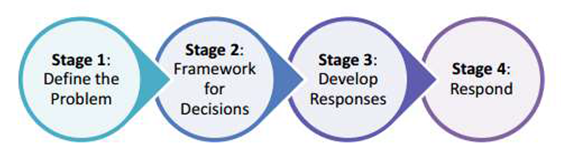
Stage 1 Define the Problem - commenced in 2014 with two reports being prepared – “Coastal Hazard Assessment” and “Coastal Risk Assessment”.
Stage 2 Framework for Decisions - began in May 2016 with a framework developed to support a collaborative decision making forum for a community led response to the issues (rather than the more traditional and previously used ‘top down’ planned approach). The framework combined a multi criteria assessment analysis with an adaptive pathways approach (combined with several other economic, social and cultural considerations) for communities to consider different management strategies, i.e. “the status quo” (do nothing/monitor the situation), “hold the line” (defend) or “managed retreat” (withdrawing, relocation, or abandonment) for specific areas along the coast for the whole of the 100 year timeframe.
Both of these stages have previously been reported through to Council in detail at the completion of the respective stages.
Stage 3 Develop the Response - two cell assessment panels (one southern and one northern) were formed with community representatives from Tangoio/Whirinaki, BayView, Westshore/Ahuriri, Marine Parade, Clive/East Clive, Haumoana/TeAwanga/Clifton. Other participants included a representative from the port, Ahuriri business, NZTA, DOC, recreational interests, and rural community board.
The Northern and Southern Cell Assessment Panels commenced their work in January 2017 and were tasked with assessing information on coastal hazards risks and developing informed recommendations for the Joint Committee’s consideration in identifying actions to respond to those risks. The panels have now completed their task in preparing a 100 year Strategy for preferred response options along the coast, focussing at this stage on priority areas (i.e. those areas deemed most at risk in the short term). The Strategy is shown at Attachment A.
Pages 11 - 16 of the Strategy detail the preferred pathways for the four priority areas of the Napier coast (Ahuriri, Pandora, Westshore and Bay View), while pages 64 – 67 detail the indicative costs for each of the pathways.
At the meeting of the
Clifton to Tangoio Coastal Hazards Strategy Joint Committee on
20 February 2018 (as shown in the draft minutes at Attachment B), the
Committee resolved to:
1) Receive the Report of the Northern and Southern Cell Assessment Panels.
2) Endorse the recommendations of the Northern and Southern Cell Assessment Panels as presented in their report dated 14 February 2018.
3) Recommend that the Napier City Council, Hastings District Council and Hawke’s Bay Regional Council endorse and adopt the recommendations of the Northern and Southern Cell Assessment Panels as presented in their report dated 14 February 2018, and commence Stage 4 (Implementation) of the Clifton to Tangoio Coastal Hazards Strategy 2120.
2.3 Issues
Partner Council reporting on Stage 3 will be completed by 3 April, 2017. Subject to the outcome of Stage 3 being endorsed, and to confirming timing for reporting back to, and seeking support from, each Tangata Whenua member of the Joint Committee, Stage 4 will be able to commence, subject to partner Council’s funding commitments and LTP processes.
Napier City Council, along with the other partner Councils, have already committed to including $100, 000 per year (uninflated) for the next ten years in its draft LTP (assuming confirmation through the LTP processes). This money is intended to cover Stage 4 of the Strategy and includes the planning phase of design and budget refinements, cost sharing and funding options and preparing for implementation. However, this funding, once confirmed, will not be available until the new financial year, 1 July 2018.
The ten years of funding in the LTP is intended to demonstrate leadership and a firm commitment by the partner Councils to facing up to one of the most pressing issues associated with climate change, i.e. sea level rise and its impacts on coastal erosion and inundation.
In the interim, budgeted costs for Stage 3 have been exceeded, leaving insufficient funds in the current financial year to proceed with any significant work in Stage 4. This exceedance has resulted from the need for more Assessment Panel workshops being held than originally intended, and a corresponding increase in inputs from external advisors.
The Partner Council representatives on the TAG consider that a “pause” is necessary, and that engaging further external advice in support of Stage 4 will need to be held over until after 30 June, 2018 and the confirmation of draft LTPs.
In practical terms, this means limited Joint Committee and TAG activity in Stage 4 between April to June 2018. From July onwards, technical expertise is expected to be required and engaged to, among other matters:
· Guide the refinement of the funding approach towards an agreed position between all Partner Councils;
· Commence implementation planning, particularly around the staging of physical works programmes in accordance with priority; and
· Commence refining high level design and costing information for agreed physical works programmes, as part of detailed design.
In the interim, TAG are expecting to be able to advance work where internal resources can be dedicated in support of it, or where external funding may be available. As an example, funding and expertise may be available through the National Science Challenges programme to support the development of triggers. There are also a range of Assessment Panel supplementary recommendations that, if adopted by the Partner Councils, could be advanced.
The Joint Committee and TAG meeting schedule for 2018 is intended to be programmed accordingly.
2.4 Significance and Consultation
The Coastal Hazards Strategy is a significant body of work that has been based on a community led collaborative planning process. Engagement with the community and key stakeholders has been a fundamental pillar of the process with opportunities provided to comment on options, the process and the Strategy itself. Pages 39-40 detail the main public feedback forums.
Regular newsletters have also kept the wider public informed of the process at key milestones and a dedicated website (https://www.hbcoast.co.nz/) has invited interested parties to become involved.
Consultation on funding issues will also be available as part of the normal Council LTP processes.
2.5 Implications
Financial
The immediate financial implications have been discussed in Section 1.3 (Issues) above, but while some preliminary discussions has occurred between the partner Councils regarding the development of a funding model to implement the recommended pathways, some key questions remain open. These include, among other things:
· The Share of Responsibilities between Councils for collecting rates in support of the physical work programmes identified by the Strategy;
· The Share of Responsibilities between Councils for seeking resource consents and implementing works;
· The detailed functioning of a ‘Contributory Fund’, particularly how targeted rates will be applied (i.e. whether rates collected from a specific coastal community are only spent in that community or whether there is an opportunity for a more general fund); and
· The public / private benefit assessment for each physical works programme, and the resulting apportionment of costs.
Stage 4 will need to resolve these issues in order for the Strategy to deliver the preferred physical solutions for each of the priority areas of the coast.
Social & Policy
One body of work that will arise from Stage 4 will be a need to review all relevant provisions of both regional and district plans to ensure there is a policy framework that supports the preferred pathways while maintaining appropriate consenting requirements through normal resource management planning processes.
Risk
The biggest risk associated with climate change is not acting. The NZ Coastal Policy statement requires Councils to plan for coastal erosion and inundation using a 100 year time frame. The three partner Councils have been proactive in developing a Strategy that meets legislative requirements, current best practice and the aspirations of the potentially most affected communities.
2.6 Options
The options available to Council are as follows:
· To adopt the report and endorse the recommendations, including commencing Stage 4.
· To receive the report but not endorse the recommendations and not commence Stage 4.
2.7 Development of Preferred Option
The preferred option is for Council to adopt the report and endorse the recommendations of the Joint Committee. The Joint Committee has had governance representation from the three partner Councils and has overseen a robust community led planning process for developing a Coastal Hazard Strategy to meet the needs of the community for the next 100 years. The implementation phase is critical in order to deliver the preferred pathways necessary to making the Napier community resilient to the potential impacts associated with coastal erosion and inundation in the face of climate change and sea level rise.
a Clifton to Tangoio Coastal Hazards Strategy 2120 (Under Separate Cover) ⇨
b Draft Minutes - Clifton to Tangoio Coastal Joint Committee - 20 February 2018 ⇩
3. Traffic Safety Improvements - Jervoistown
|
Type of Report: |
Operational |
|
Legal Reference: |
N/A |
|
Document ID: |
448099 |
|
Reporting Officer/s & Unit: |
Robin Malley, Team Leader Transportation |
3.1 Purpose of Report
To provide an update to Council on the consultation process undertaken with the Jervoistown community regarding road safety issues; and to recommend the installation of traffic calming features on Jervois Road and Napier Street in response.
|
That Council a. Notes the results of engagement with the Jervoistown community
b. Approves the installation of a series of traffic calming features on Jervois Road and Napier Street.
|
|
That the Council resolve that the officer’s recommendation be adopted. |
3.2 Background Summary
The Jervoistown community has been engaged with Council for a number of years, initially following proposals to construct a footpath on Jervois Road. This was in response to two pedestrian fatalities in New Zealand, one of which occurred in Bay View. The footpath proposal generated strong opposition from residents and it was agreed that Council’s Community Services team would work with residents to investigate alternatives.
A trial traffic calming plan was agreed, with tree planters located at the carriageway edge supported by road markings installed in March 2016. The focus of these works was Jervois Road, although planters were also located at the entrances to Napier Street. Following positive community feedback and evidence of speed reduction, the planters were left in in place with a view to developing the scheme to include Burness Road and Napier Street.
The subsequent liaison with the community has involved a number of meetings which have resulted in a high level of engagement with a specific section of the community. In 2017 Council presented an opportunity for all residents to provide feedback on various options through a survey issued to all households. 71 responses were received (40% response rate), providing preferences for interventions. The results of the survey were relayed to the community at a meeting in December 2017.
3.3 Issues
The main issues to be considered are traffic speeds, traffic volumes and road safety, particularly with regard to vulnerable users such as pedestrians, cyclists, the mobility impaired and children. Each of these is briefly discussed in this section.
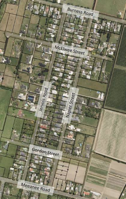
Traffic speed surveys have been undertaken on both Jervois Road and Napier Street over a number of years, most recently in June 2017. The recent surveys recorded 85th percentile (the speed which 85% of vehicles are travelling at or below) mid-block speeds of 53km/h on Jervois Road and 56km/h on Napier Street. Maximum speeds of 116km/h and 119km/h were recorded at the same locations. The following plan summarises the most recent speed survey results.
Plan showing 85th percentile and maximum speeds measured in 2017 (km/h)
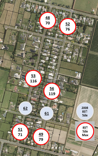
Speed surveys undertaken prior to the installation of the existing calming features returned an 85th percentile speed of 61km/h. Surveys undertaken 1 month after the installation in 2016 returned an 85th percentile speed of 54km/h. Follow up surveys returned an 85th percentile speed of 57km/h three months after installation. The speeds recently observed are consistent with these latter observations, demonstrating that while speeds did ‘bounce’ after users had become accustomed to the calming features, they have not returned to pre-installation levels.
The recorded speeds would not normally be sufficient to warrant an intervention, however, given the narrow carriageway width and lack of footpaths, these speeds will appear faster and pose a higher level of risk than a normal urban street with kerbs and footpaths.
Traffic Volumes for Jervois Road and Napier Road were also recorded during the speed surveys. Annual Average Daily Traffic volumes were calculated at 670 vehicles for Jervois Road and 614 vehicles for Napier Street in 2017.
Of these volumes, approximately 15% of vehicles using Jervois Road and 18% of those using Napier Street were travelling through the area (between Meeanee Road and Tannery Road). These proportions appear to be quite high given that there is an equal journey length, higher speed alternative of using Tannery Road.
Long-term residents will have noticed an increase in traffic activity over the last few years related to residential subdivisions, concentrated around the western ends of Burness Road and McElwee Street. Some of this activity relates to the construction of infrastructure and houses and will be short term, with different traffic patterns to those normally experienced. The rest of the increase will be related to the increased residential base and will be sustained.
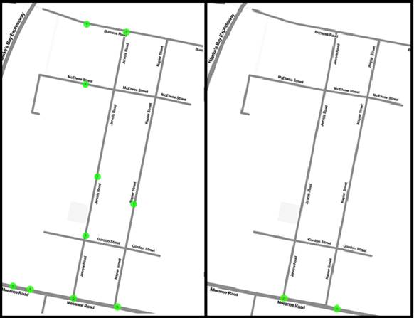
Accident records for the last ten years have been assessed, showing no injury accidents occurring on Jervois Road, Gordon Road, McElwee Street, Burness Road or Napier Street during that period. Seven non-injury accidents occurred on those roads during the same period. None of the accidents involved vulnerable users.
Plan showing recorded accidents (2007 to 2017) in Jervoistown. All accidents shown on left, accidents resulting in injury on the right.
3.4 Significance and Consultation
The issues covered in this report have been subject of extensive consultation with the Jervoistown community, primarily through public meetings but also including surveys mailed to all residents. A summary of the responses is included in the Development of Preferred Option section of this report.
If Council supports the recommendation of traffic calming, the design and location of this will also be developed with opportunities for community input.
None of the options tabled meet the criteria for additional or targeted engagement under the NCC Significance and Engagement Policy.
3.5 Implications
Financial
Budget has been identified through the LTP planning process at a level adequate for construction of a footpath and traffic calming in Years 1, 6 & 7 of the 2018-29 LTP. Further, budget has been identified in the current financial year’s programme for minor works. The work is eligible for NZTA funding assistance under the ‘Minor Improvements’ Work Category (changing to ‘Low Cost Low Risk Improvements’ as of 2018/19)
Social & Policy
N/A
Risk
This issue falls within the normal risk profile of Council as Road Controlling Authority and does not present specific risk exposure.
3.6 Options
The options available to Council are as follows:
a. Do Nothing. This option would see the existing gateway features retained and maintained but with no further development of the road environment.
b. Install traffic calming features on Jervois Road and Napier Street. Any additional traffic calming installed in Jervoistown would have to include both Jervois Road and Napier Street and also Burness Road. Should treatments not be installed across the area as a whole, there would be an imbalance of speeds across the area, leading to a risk of users exposed to different levels of risk on road environments which look and feel very similar. The cost of this option is estimated between $50,000 for minimal, basic interventions and $150,000 for a more developed treatment using materials better suited to a more rural environment.
c. Install footpaths. The roads within Jervoistown do not have any footpaths, with vulnerable users either sharing the road or using the berms. The berms are generally well maintained, but are primarily grass, with open drains on both sides. Formation of footpaths, on one or both sides, would provide a facility which could be used all year round with a higher level of service for users, particularly wheeled mobility users and children without adequate confidence or experience to safely use the road. New footpaths could be formed progressively, with one side of each road constructed in the first instance. Footpaths on McElwee Street and Gordon Street could be included later on although traffic volumes and speeds on these roads means that sharing road space is more appropriate here. The cost of this option is estimated between $150,000 for limesand footpath on one side each of Jervois Road and Napier Street, to $500,000 for concrete footpaths on both sides of Jervois Road and Napier Street.
d. Install Footpath and traffic calming. The final option is to install both traffic calming features (at a full, area wide level, or a reduced coverage or frequency) along with footpaths. The cost of this option is estimated between $200,000 and $650,000.
e. One-Way System. A fourth option of introducing one-way operation was included in consultation with the community. This option has not been considered in detail, as there is a risk of encouraging higher speeds, introducing additional turning movements and increasing traffic volumes on McElwee Street and Gordon Street. One-way operation would not address the speed and vulnerable user concerns of the community.
3.7 Development of Preferred Option
The driving principle behind the selection of options is to reduce conflict between vulnerable road users (pedestrians, cyclists, children playing) from speeding vehicles. This is achieved through separating the users (provision of footpaths) and/or reducing risk by reducing speed (traffic calming). All options other than the Do Nothing option seek to satisfy this principle. The exact nature of the options, such as the design, location, frequency of any calming features; or the width, location or surface type of footpaths has not been developed at this stage.
Do Nothing
It is clear that the Do Nothing option will not address the desires of the community in respect of reducing traffic speeds and increasing safety. There is nothing to suggest that the existing situation (vehicle speeds and crash history) would worsen with no intervention. Risk may increase as background traffic levels increase. However, there does not appear to be significant opportunity for further subdivision in Jervoistown beyond that already consented.
Community feedback includes several comments that the current planters are not safe.
Traffic Calming on Jervois Road and Napier Street
This is the recommended option. It was the most popular first choice for those residents who responded to the 2017 survey.
Appropriately designed and spaced traffic calming features will reduce speeds through the area, reducing the likelihood of accidents and the severity of any accidents which may happen. Reduced vehicle speeds will mean that vulnerable users for whom the grass berms are unsuitable can share the road space more comfortably and safely.
Traffic calming is likely to deter through traffic in favour of Tannery Road which will result in lower traffic volumes, further reducing exposure to risk for all users.
Footpaths
The construction of footpaths on Jervois Road and Napier Street, whether on one or both sides of the road would result in improved safety for vulnerable users. Improvements would be increased, but not doubled, if paths were constructed on both sides. Footpaths would provide an all-weather alternative to walking on the berm or in the carriageway, which may also result in increased levels of walking and cycling.
Introduction of footpaths may result in increased vehicle speeds as drivers feel that vulnerable users are separated from danger. This risks injuries of greater severity if accidents do occur.
There is some concern among residents that footpaths would detract from the rural feel of Jervoistown. While the aesthetic distinctions between semi-rural and urban environments are subjective, footpaths could be constructed to minimise the potential ‘urbanisation’ such as meandering alignments and use of limesand rather than concrete. Construction of a footpath would not be accompanied by kerb and channel.
Footpaths and Traffic Calming
From a traffic safety perspective, this would be the ideal response. The reduction in speed and through traffic volumes resulting from traffic calming along with the separation of vulnerable users would reduce risk significantly through reduced frequency of conflicts and reduced severity.
Summary of consultation responses.
|
Option |
Traffic Calming Extension |
One Way System |
Footpath |
Traffic Calming and Footpath |
|
1st Choice (No. of responses) |
34 |
0 |
15 |
18 |
|
2nd Choice (No. of responses) |
5 |
14 |
7 |
15 |
|
3rd Choice (No. of responses) |
11 |
2 |
18 |
8 |
|
4th Choice (No. of responses) |
1 |
27 |
9 |
9 |
The community survey offered an opportunity for respondents to make comments. These comments were helpful in understanding the wider concerns of the community, but did not provide a great deal of consistency from which a solution could be developed. Responses ranged from “Traffic calming would slow people down. Footpath would enable our children to walk in a safe space” to “No to footpath or combination. No further adjustment to current setup. Rural concept and does not require interference from Council”.
This report seeks approval for the type of intervention recommended. Should Council support the recommendation, officers will develop and evaluate some alternatives for traffic calming treatments, which will then be presented to the community for feedback.
Regardless of the outcome of this project, Council will continue to monitor speeds, traffic volumes and safety records as with all roads in the City and respond accordingly to any significant changes.
Strategy and Infrastructure Committee - 20 February 2018 - Open Agenda Item 4
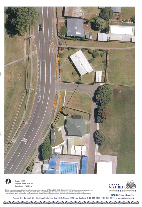
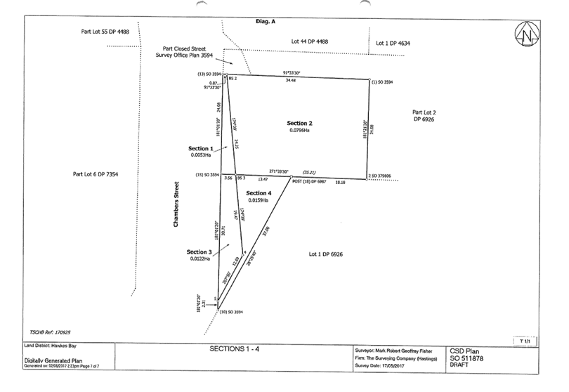
4. 20 & 21 Chambers Street, land legalisation - land to be declared road
|
Type of Report: |
Legal |
|
Legal Reference: |
Public Works Act 1981 |
|
Document ID: |
448863 |
|
Reporting Officer/s & Unit: |
Bryan Faulknor, Manager Property Jenny Martin, Property and Facilities Officer |
4.1 Purpose of Report
To obtain a formal declaration from Council under Section 114 of the Public Works Act 1981 that the land in question be declared road.
|
That Council a. Resolve to re-approve, under Section 114 of the Public Works Act 1981, to declare the land in the Schedule below to be road.
Schedule
Hawkes Bay Land District – Napier City
|
|
That the Council resolve that the officer’s recommendation be adopted. |
4.2 Background Summary
In October 2017, Council approved the land to be declared road under Section 115 of the Public Works Act 1981. The decision was inadvertently made under the wrong section of the Act and now needs to be declared road under Section 114 of the Act.
Early in 2017 it was revealed that an historical anomaly exists to the front of 20 and 21 Chambers Street in that some of the formed road and footpath falls within the legal boundary of the two privately owned properties. The owners of both properties have agreed that Council remedy the situation by redefining the boundaries to reflect the current position.
4.3 Issues
There are no issues.
4.4 Significance and Consultation
Both property owners have been consulted.
4.5 Implications
Financial
Funding for the compensation and legalisation is to be provided from existing roading budgets.
Social & Policy
Not applicable
Risk
Not applicable.
4.6 Options
The options available to Council are as follows:
a. That Council approve the resolution under Section 114 of the Public Works Act 1981.
4.7 Development of Preferred Option
Not applicable.
a Chambers Street legalisation ⇩
|
|
That the public be excluded from the following parts of the proceedings of this meeting, namely:
AGENDA ITEMS
1. Reappointment of Chair to Hawke's Bay Museums Trust
2. Council Projects Fund - Application
The general subject of each matter to be considered while the public was excluded, the reasons for passing this resolution in relation to each matter, and the specific grounds under Section 48(1) of the Local Government Official Information and Meetings Act 1987 for the passing of this resolution were as follows:
|
General subject of each matter to be considered.
|
Reason for passing this resolution in relation to each matter.
|
Ground(s) under section 48(1) to the passing of this resolution.
|
|
1. Reappointment of Chair to Hawke's Bay Museums Trust |
7(2)(a) Protect the privacy of natural persons, including that of a deceased person |
48(1)A That
the public conduct of the whole or the relevant part of the proceedings of
the meeting would be likely to result in the disclosure of information for
which good reason for withholding would exist: |
|
2. Council Projects Fund - Application |
7(2)(i) Enable the local authority to carry on, without prejudice or disadvantage, negotiations (including commercial and industrial negotiations) |
48(1)A That
the public conduct of the whole or the relevant part of the proceedings of
the meeting would be likely to result in the disclosure of information for
which good reason for withholding would exist: |
Strategy and Infrastructure Committee
|
Meeting Date: |
Tuesday 30 January 2018 |
|
Time: |
3pm |
|
Venue |
Council Chambers |
|
Present: |
The Mayor, Councillors Price (In the Chair), Councillors Boag, Brosnan, Dallimore, Hague, McGrath, Tapine, Taylor, White, Wise and Wright |
|
In Attendance: |
Chief Executive, Director City Strategy, Director City Infrastructure, Director Corporate Services, Director City Services, Director Community Services, Manager Property, Manager Communications and Marketing, Manager Regulatory Solutions, Strategic Planning Lead |
|
Administration: |
Governance Team |
Strategy and Infrastructure Committee - 30 January 2018 - Open Minutes
Apologies
|
That the apology from Councillor Jeffery be accepted. |
Conflicts of interest
Nil
Public forum
Mr Barrie Crabbe – City Water Supply
Mr Crabbe provided a brief over view of his employment history, noting that several roles had brought him in contact with irrigation and water use, and he had had the opportunity to learn about the Hawke’s Bay aquifer in this way.
He noted that the aquifer is confined with most wells under positive pressure. Water that is not used runs under pressure towards the sea.
Mr Crabbe noted that the Chief Executive had made a statement that the low water level emergency towards the end of 2017 was created by overuse of water by the public.
Mr Crabbe challenged this statement, saying it was his belief that there were a number of issues with the Council system that created the shortage. He contended that Council monitoring equipment had not been working at the time; Council should have brought in more pumps and did not; the Guppy Road bore was out of commission; and the recently constructed reservoir is not able to be used as the roof is leaking.
Mr Crabbe stated that he believed the people of Napier did not create the problem, but rather the Chief Executive and staff of Council did. He stated that there is plenty of water and the issue is with Council’s infrastructure –if more storage is required, provide this; if more wells are required, put these in place.
He noted that close to the 300ml well at the River end of Guppy Road is a 75ml well which could be brought online at little cost. Under the Human Rights Act people could choose to use this well, at their own risk. Daily monitoring could be undertaken of this well at the same time as the 300 ml bore.
Announcements by the Mayor
Nil
Announcements by the Chairperson
The Chair noted that compared to many international cities recently visited while on leave, Napier is extremely well presented and is a credit to the Council staff.
Announcements by the management
Nil
Confirmation of minutes
|
That the Minutes of the meeting held on 22 November 2017 were taken as a true and accurate record of the meeting.
|
Notification and justification of matters of extraordinary business
(Strictly for information and/or referral purposes only).
Strategy and Infrastructure Committee - 06 March 2018 - Open Agenda
1. Leasehold Land Policy Review
|
Type of Report: |
Legal and Operational |
|
Legal Reference: |
Local Government Act 2002 |
|
Document ID: |
430497 |
|
Reporting Officer/s & Unit: |
Richard Munneke, Director City Strategy Kim Anstey, Planner Policy/Analyst Bryan Faulknor, Manager Property |
1.1 Purpose of Report
The purpose of this report is for Council to consider a review of the Investment Property Portfolio policy through the long term plan process.
|
In response to questions from Councillors it was clarified that: · The Hawke’s Bay Land Empowering Act applies to revenue generated rather than capital gained from a sale; more clarification on this will be provided as and when any sales are proposed. · The Act allows Council to sell leasehold land at its discretion; regardless of where the land is located. The income from the sale would be ring-fenced for reinvestment in another revenue producing asset. All the proceeds are targeted for use in the marine/ harbour area. · Funding the inner harbour is important for Council to protect on behalf of rate payers. Each potential sale would be approached on a case by case basis and assessed by the Audit and Risk Committee to ensure that the lease is being replaced by an appropriate other income opportunity. · Previous consultation on the topic had indicated strong support from current lessees. There were very few submissions raising concerns, and most of these noted that ensuring that investments were protected on behalf of ratepayers was the key focus. Council agrees that this is extremely important and any proposed sale would only progress should an equally or more lucrative replacement investment have been found.
|
|
That Council
a. Direct officers to consult on the proposed Investment Property Portfolio policy changes as part of the Long Term Plan process, including the following amendments:
· To allow freeholding of specific land identified in the June 2016 Boffa Miskell report “Napier City Investment Portfolio: Urban Landscape Strategic review” as non-strategic, on a case by case basis and only when alternative and suitable investments can be found. · That recommendations on the freeholding of all identified non- strategic land be considered by the Audit and Risk Committee in the first instance for recommendation to Council. · That the sale of leasehold land be a delegation of Council. · That a divestment procedure be established and approved by Council resolution prior to the release of any leasehold land, should the policy be adopted.
|
2. Summer Street Party - Sale of Food
|
Type of Report: |
Operational |
|
Legal Reference: |
Local Government Act 2002 |
|
Document ID: |
440277 |
|
Reporting Officer/s & Unit: |
Fleur Lincoln, Strategic Planning Lead |
2.1 Purpose of Report
To obtain a Council resolution to allow food trucks to operate within Emerson Street at the upcoming Summer Street Party on 17 March 2018 in accordance with the Trading in Public Places Bylaw 2014.
|
In response to questions from Councillors it was clarified that: · Consultation with retailers in the Emerson Street area was undertaken by the Napier City Business Association on behalf of Council. · Feedback was primarily positive on the street party. · Retailers wanted assurances that food trucks offering similar food to them would not be positioned in front of their premises, so positioning was important. They did note that, should the Mission Concert proceed, the food trucks would help relieve pressure on the cafes from the large numbers of people in the city. · Council staff have worked with the tour operators to provide an alternate route down Dalton Street. |
|
That Council
a. Allow mobile food vendors to operate within the public spaces of Emerson Street on the 17th March 2018 as part of the Summer Street Party event, and as approved by Council’s events team.
|
3. Temporary Liquor Ban - Mission Concert
|
Type of Report: |
Legal and Operational |
|
Legal Reference: |
Local Government Act 2002 |
|
Document ID: |
429442 |
|
Reporting Officer/s & Unit: |
Hayleigh Brereton, Manager Regulatory Solutions |
3.1 Purpose of Report
To consider the formal request from New Zealand Police for a temporary liquor ban on the roads adjacent to the Mission Estate Winery during the 2018 concert.
|
In response to questions from Councillors it was confirmed that: · Signage will be up in affected streets advising the public that they are now in a liquor ban area. Rubbish bins can be placed by the signs and in the area so that any bottles and cans are not left on the street.
|
|
That Council
a. Approve, pursuant to section 147 of the Local Government Act 2002 and the Napier City Council Public Places Liquor Control Bylaw 2014, the following areas as a “Specified Public Place” where the consumption, possession and bringing of liquor into is prohibited from 09.00 am to 12.00 midnight on Saturday 17 March 2018.
The area to be designated as a “Specified Public Place” are all those public places, reserves, roads and footpaths on both sides of the road within the area described as:
Church Road from Wharerangi Road to Kent Terrace Avenue Road from Church Road to Avondale Road Mission Road from Church Road to Auckland Road Montpelier Drive full length Tironui Drive full length Irene Mooney Place full length Bishops Close full length Pukekura Place full length Ennor Place full length
|
4. Herschell and Byron Street Parking Reconfiguration
|
Type of Report: |
Legal and Operational |
|
Legal Reference: |
Traffic Regulations |
|
Document ID: |
433679 |
|
Reporting Officer/s & Unit: |
Hayleigh Brereton, Manager Regulatory Solutions |
4.1 Purpose of Report
To formalise the Herschell Street off street car parking reconfiguration and the Byron Street on street parking charge resulting from the relocation of the Napier Public Library.
|
In response to questions from Councillors it was advised that: · Disability parks have been provided around the Library/ MTG complex. The plan will be reviewed to ensure appropriate numbers of disability parks are included in the wider affected area. · Council staff have been working closely with the Masonic to ensure there is less confusion between public parking, leased parking and the parking for the hotel. · Other current parking lessees are being offered other options around the area as these become available.
|
|
That Council
a. Convert the Herschell Street car park from a leased car park to a pay and display car park. b. Convert the on street car parking on Byron Street to pay and display c. Set the tariff for car parking at $1.00 per hour for both the car park and on street parking.
|
5. Ground lease - Eskview and Districts Rugby Football Club Incorporated
|
Type of Report: |
Legal |
|
Legal Reference: |
Reserves Act 1977 |
|
Document ID: |
434200 |
|
Reporting Officer/s & Unit: |
Bryan Faulknor, Manager Property Jenny Martin, Property and Facilities Officer |
5.1 Purpose of Report
To obtain Council approval to grant a new ground lease to the Eskview and Districts Rugby Football Club Incorporated for the land occupied by the Club’s building on Petane War Memorial Domain for a term of 15 years with one 15 year right of renewal.
|
There was no discussion on this item. |
|
That Council:
a. Approve a new ground lease be granted to the Eskview and Districts Rugby Football Club Incorporated for the land occupied by the Club’s building on Petane War Memorial Domain for a term of 15 years with one 15 year right of renewal.
b. Approve that the terms and conditions of the lease will be as per Council’s standard terms and conditions for leases of Reserve land to community groups. The initial ground rental will be a nominal rental of $200.00 plus GST per annum, reviewed annually according to the method laid out in the standard terms described above.
|
6. 15 Craven Terrace, land legalisation - land to be declared road
|
Type of Report: |
Legal |
|
Legal Reference: |
Public Works Act 1981 |
|
Document ID: |
434199 |
|
Reporting Officer/s & Unit: |
Bryan Faulknor, Manager Property Jenny Martin, Property and Facilities Officer |
6.1 Purpose of Report
To seek Council’s approval pursuant to Section 114 of the Public Works Act 1981 that the land in question be declared road.
|
In response to questions from councillors it was confirmed that: · The land was independently assessed and valued; market rates were used in the transaction.
|
||||||
|
That Council
a. Declare that, pursuant to Section 114 of the Public Works Act 1981, the land in the schedule below to be road. SCHEDULE
Hawke’s Bay Land District – Napier City
|
7. Joint Council Waste Futures Project Steering Committee - Minutes - 23 November 2017
|
Type of Report: |
Procedural |
|
Legal Reference: |
Local Government Act 2002 |
|
Document ID: |
430450 |
|
Reporting Officer/s & Unit: |
Deborah Smith, Governance Advisor |
7.1 Purpose of Report
To present to Council the draft Minutes of the Joint Council Waste Futures Project Steering Committee from 23 November 2017.
|
In response to questions from Councillors it was confirmed that: · The consultation document uses a large number of illustrations to ensure a wide understanding of the questions as possible. The wording will also be reviewed to ensure it is as simple and easy to understand as possible for those whose primary language is not English and so on. Cr Brosnan advised that a meeting with private waste operators has been scheduled for 22 February 2018 to discuss the strategy and receive their feedback.
|
|
That Council
a. Receive the draft Minutes of the Joint Council Waste Futures Project Steering Committee from 23 November 2017.
|
The meeting closed at 3.30pm