|
Future Napier Committee - 30 July 2020 - Attachments
|
Item 1
Attachments a
|
Summary of District Plan Review recommendations for Council
endorsement
19th March 2020
– 25th June 2020
The preliminary policy position
recommendations below will form the basis for the content in the Draft Plan and
therefore form the adopted policy position of Council for community engagement
through the draft District Plan process (scheduled for November 2020 –
February 2021).
Feedback from stakeholders and
the public through the November 2020 – February 2021 draft District Plan
engagement will be reported back to Council in early 2021. Council will
consider potential revisions to the preliminary policy position in response to
feedback prior to notifying the proposed District Plan for formal submissions
in 2021.
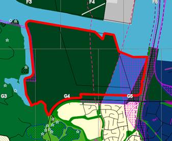
Premier Park for Ahuriri
Estuary (Rezoning of Lagoon Farm to a stormwater and ecological zone)
· To be reported on as a separate agenda item
Commercial Zones: City Centre
Zone, Mixed Use Zone for City fringe, Napier City Heritage precinct, and other
commercial zones
Residential
• All centres: Residential permitted above ground level
(acoustic insulation in City Centre and Town Centre – subject to heritage
controls)
• Mixed
use zone: Residential permitted (acoustic insulation)
• Large format retail: No residential
• All residential in commercial zones:
• Design assessment for multi-unit
development
• Outlook / privacy requirements
• Minimum permitted unit size
Height
|
Zone
|
Height limit
|
|
Napier City
Heritage Precinct
|
10m
|
|
City Centre
Zone (outside heritage precinct)
|
24m
|
|
Mixed Use
Zone
|
12m
|
|
Medium
Density Residential
|
12m
|
Retail
|
Zone
|
Permitted
retail
|
Permitted
hospitality
|
|
City
Centre Zone –
Napier Heritage Precinct
|
No limits
|
No limits
|
|
City
Centre Zone –
outside Napier Heritage Precinct
Mixed Use
Zone –
City Centre fringe
|
Minimum
500m² GFA permitted
Between
200m² - 500m² subject to restricted discretionary activity resource
consent
|
No limits
|
|
Town
Centre (Taradale)
|
Maximum floor
area 1,000m² GFA
|
No limits
|
|
Local
Centres
|
Maximum floor
area 500m² GFA
|
No limits
|
|
Neighbourhood
Centres
|
Maximum floor
area 200m² GFA
|
No limits
|
|
Mixed Use (Ahuriri)
|
Ahuriri
– retail only related to goods produced onsite (maximum 20% of GFA)
|
Permitted in
West Quay
Discretionary
activity for other new hospitality (outside West Quay)
|
|
Large
Format Retail (Prebensen
Drive)
|
Minimum
1,000m² GFA
|
One
hospitality activity per site
Maximum GFA
150m²
|
Office
|
Zone
|
Permitted
office
|
|
City
Centre Zone – Napier Heritage Precinct
|
No limit
(likely smaller offices due to building controls)
|
|
City
Centre Zone – outside Napier Heritage Precinct
|
Minimum
500m² GFA
|
|
Mixed Use
Zone –
City Centre fringe
|
Permitted if
ancillary to light industry
Otherwise
Restricted Discretionary (encourage offices in City Centre zone)
|
|
Town
Centre (Taradale)
|
No limit
|
|
Local
Centres
|
No limit
|
|
Neighbourhood
Centres
|
Permitted
above ground floor
Otherwise
Restricted Discretionary (does office displace neighbourhood centre functions
e.g. dairy)
|
|
Mixed Use
(Ahuriri)
|
• Permitted if ancillary
to light industry
• Restricted Discretionary
in identified business hub and West Quay
• Otherwise Non-complying
Subject
to Ahuriri workstream
|
|
Large
Format Retail (Prebensen Drive)
|
Non-complying
|
Industrial
|
Zone
|
Permitted
Industrial
|
|
City
Centre Zone – Napier Heritage Precinct
|
Non-complying
|
|
City
Centre Zone – outside Napier Heritage Precinct
|
Discretionary
activity for Light Industry (light manufacturing and servicing; repair and
maintenance services; warehousing and storage)
|
|
Mixed Use
Zone –
City Centre fringe and Ahuriri
|
Permitted
– Light Industry only
|
|
Town
Centre, Local Centres, Neighbourhood Centres
|
Non-complying
|
|
Large
Format Retail (Prebensen Drive)
|
Non-complying
|
City Centre and Town Centre
• All new buildings require resource consent
(restricted discretionary, non-notified where all controls met)
• Urban Design Panel: optional but free – requires funding (next
LTP)
• Assessment criteria / design guidelines:
• Break up mass of buildings, emphasise
corners
• Attractive street frontages, visual
interest, outlook - especially key entrance routes
• Avoid long, blank walls
• Assessment criteria / design guidelines
(continued):
• Clear entrances
• Minimise glare and wind
• Durable and easily maintained materials and
finishes
• Integrated roof form
• Connectivity for large blocks
Te Aranga Design Guidelines? - guidance/advocacy approach
Napier Heritage precinct
• 10m height
• Specific criteria and design requirements
within the heritage precinct to recognise the character
• Paint colours managed for all of precinct
• Control of external additions and
alterations
City Centre and Town Centre
• Height:
• City Centre: 24m but step backs from adjoining properties required
over 12m
• Town Centre: 12m (3-4 storeys)
• Verandahs: Continuous verandahs required except if conflicting
with heritage
• Frontages: Buildings to adjoin street, glazing, no
residential at ground level within 10m of street frontage
• Residential design requirements
Local and Neighbourhood Centres
• New buildings: No resource consent requirement
• Height: 10m (2-3 storeys)
• Height in relation to boundary: 3m + 45 degrees from residential zone
boundaries
• Yards: 6m from residential zone boundaries
• Active street frontages: Identified streets to require verandahs,
glazing, no residential units within 10m of street frontage
• Other streets: Either as above, or minimum 2m wide landscaping
Mixed Use Zone
• New buildings: resource consent requirement for new large buildings
(over 400sqm GFA). Additional criteria apply in heritage character precincts
(e.g. Iron Pot character, Ahuriri)
• Landscaping: For car parks and street frontages (where buildings
set back)
Large Format retail Zone
• New buildings: Resource consent / design assessment (includes
pedestrian/cycle access consideration)
• Height: 12m
• Setback: 20m from Prebensen Drive frontage
• Outdoor storage: Screened from public view
• Landscaping: for car parks
All commercial zones - Resilience
• Vertical evacuation towers:
• Assessment criteria for height
infringements to enable consideration of resilience benefits
• Design guidance to require consideration of
providing structural integrity and availability of public access to rooftops to
provide evacuation options
• Criteria for new buildings: Maintain identified evacuation routes (e.g.
through-site links)
Rezonings
Consider the following rezoning
options for consultation in the Draft Plan:
Established neighbourhood
shops/recently consented ones from General Residential Zone to Neighbourhood
Centre Zone.
Commercial area south of
Puketapu/Meeanee Roads to Mixed Use Zone
Mixed Use Zone for Ahuriri
(as part of targeted stakeholder engagement)
Confirmation that targeted
stakeholder engagement would explore rezoning options for the Ahuriri Mixed Use
Zone, comparing the status quo with more refined zoning that explored rezoning
parts of the Ahuriri Mixed Use Zone to Industry Zone (around and adjacent to
the Bulk Oil Facilities), Mixed Use Zone and Business Hub Area, General
Residential Zone and retention of the existing Mixed Use Zone in the remaining
areas.
Port Noise
Confirmation that targeted
stakeholder engagement would explore the Port of Napiers proposals for how to
address Port Noise issues in the Draft Plan.
The Port of Napier presented
their position on the new Port Noise provisions they are recommending to be
included into the Draft Plan. The proposal is to replace the existing
plan provisions with the current mitigation approach undertaken by the Port of
Napier as a voluntary scheme administered as part of the Port Noise Management
Plan. This will make the voluntary scheme mandatory and enforceable
through the District Plan.
Open Space – Temporary
Events
Parks and reserves - Change of
status for commercial activities from Non Complying to Discretionary Activities
Parks and reserves – Up
to 18 temporary events per year per site in – Marine Parade Recreation
Control Area, Open Space Zone (Coastal Environment) and Anderson Park
Parks and reserves – Up
to 5 temporary events per year per site in all other parks and reserves.
Restricted Discretionary
resource consent to exceed allowances.
McLean Park
Hours for sporting events with
amplified sound Sundays – Thursdays extended from 10pm to 11pm for
maximum of 3 days per year
Rodney Green Centre
Non Sporting Events extended
from 5 to 10 per year
Temporary Events on Private
Land
Amplified Noise for
entertainment – reduce permitted noise limits from 90dbA to:
75dB
LAeq Sunday – Thursday max 10pm
80
dB LAeq Saturdays, Sundays or any day preceeding a public holiday max 11 pm
except 1am New Year’s Eve
Restricted
Discretionary to exceed
Construction - specific rules
in line with NZStandard to be put into District Plan for clarity rather than
just reference to the NZStandard
General Noise
Confirmation of approach where
lower noise limits in Residential zones, moderate in Rural zones. Higher in
City Centres and Industrial Zones
City Centre –
10pm-midnight Thursday, Friday, Saturday and day before a public holiday 60dBA
(up from 50dBA)
Day Care Centres - additional
5dBA above zone Monday to Friday 7am to 6pm but -5dBA all other times
Noise Sensitive Activities
required to acoustically insulate themselves from noise arising within; City
Centre, Mixed Use Zones, Industrial Zones, within 80 metres of a rail corridor
or state highway. Requires acoustic insulation and mechanical ventilation
(approx. $15 000 per house)
Helicopter landing areas
– new rules to balance enabling flight paths for helicopter landing areas
while protecting amenity for nearby residential dwellings.
Rural Production Activities
(Bird scaring and frost fans) – retain harmonized rules with HDC
Signage
Central Character Precinct
(Heritage) – No ACM Boards, no signs on roof of verandah, unpainted
surfaces must remain unpainted
Footpath signs – remove
from District Plan as addressed under Footpath Management Policy
Temporary signs (election
signs) reduce the timeframe to meet current legislative requirements
Genetically Modified
Organisms
Harmonize provisions with HDC
– Prohibit the outdoor release of GMO’s and outdoor field trials of
GMO’s
Activities on Surface of
Water
Status quo - retain harmonized
rules with HDC
Lighting
McLean Park
Hours for sporting events -
align additional lighting hours with extended noise hours
|
Future Napier Committee - 30 July 2020 - Attachments
|
Item 2
Attachments a
|
a.
Working Draft Napier City District Plan:
Part 3: Area Specific Matters: Special
Purpose Zone
Chapter X:
Te Whanganui-a-Orotū (Ahuriri Estuary) Ecology and Stormwater
Treatment Zone (AESZ)
Introduction
This zone applies to the southernmost
area of land adjacent to Te Whanganui-a-Orotū (Ahuriri Estuary) that was
uplifted in the 1931 earthquake (commonly known as “Lagoon
Farm”). The area has the Ahuriri Estuary on its northernmost side,
and is adjacent to Prebensen Drive and the Taipō Stream.
The area has potential for ecological
improvements and the creation of stormwater treatment wetlands and aquatic
habitats. The context of the land within this zone includes the cultural and
seismic history, and its location adjacent to an outstanding waterbody and an
area of regional and national significance for its ecological values.
The ecological vision for the Lagoon
Farm site is restoration, expansion and enhancement of a high value coastal
ecosystem though the creation of a new complex mosaic of freshwater wetland
habitats connected to a constructed salt marsh[1].
The land has been altered significantly
by both natural events (the 1931 earthquake) and subsequent human intervention
such as drainage and flood control schemes. A number of urban
waterways and drains traverse the area, some of which carry contaminants, and
discharge into the estuary. There are stopbanks in place; however,
natural hazards remain an issue. Much of the land within the zone is low lying
and vulnerable to ponding, tsunami, inundation and seismic events. The
area receives floodwaters from urban areas.
The zone is located adjacent to the
Hawke's Bay Airport, and parts of it are within the airport noise boundary and
height controls apply. This makes these areas unsuitable for sensitive
land uses, including residential and rural residential development.
The proximity to the City and the
cycleway means that the publicly accessible areas are well used. Public
access needs to be located away from sensitive activities and habitats to
ensure the high values associated with indigenous and migratory species in the
adjacent estuary are retained and improved.
‘Premier Park’ and
‘Great Urban Areas’ are two key outcomes. A key value
mentioned in relation to the Ahuriri estuary is Mauri – to visibly see
mauri, to be able to safely swim in the water, and safely eat from the
estuary. To achieve
these key objectives, the provisions in this zone promote the following
outcomes:
- To improve the stormwater
retention function of the site, and treat stormwater pollutants in constructed
wetlands before it reaches the estuary.
- To reduce the amount of sediment and
other potential sources of contaminants entering waterways and the estuary
- Use and development
is carefully controlled and must be compatible with the values of the adjacent
Ahuriri estuary, wildlife reserve and airport
- The estuarine / wetland and stream edges
are planted, ecosystem types that are missing from the area are established, and
a more natural estuary edge is created.
- Areas of
significant indigenous vegetation and significant habitats of indigenous fauna
in the adjacent estuary and its margins are protected and improved
- The values and
interests of mana whenua are recognised and reflected in the use and
development of the area
- The exercise
of kaitiakitanga and the ethic of stewardship is promoted
- The
life-supporting capacity of soil and water is safeguarded, and the intrinsic
values of water bodies and ecosystems are recognised
- Use and
development occurs in a way that recognises adjacent land uses (such as the
airport); improves the management of stormwater discharges, and is compatible
with restoration and safeguarding the values of water and the estuary
- Activities are
set back from waterbodies and the coastal marine area to manage potentially
contaminated stormwater run-off; to promote opportunities to improve the
natural character of the area, and to safeguard the life supporting capacity of
natural resources and eco-system health
- Indigenous biological diversity and
ecosystem functioning of the adjacent Ahuriri estuary and its margins is
maintained and improved
The planning approach in this zone
allows the council to promote strategic outcomes for improving ecosystems and
water quality as a priority, to control potential effects on the ecology of the
estuary, and consider the natural hazards, soils and topography and cultural
interests when determining what development (if any) is appropriate.
Activities are to be set back from the
estuary and waterbodies to manage potentially contaminated stormwater run-off;
to provide opportunities to reinstate some of the natural character; and to
improve the life supporting capacity of natural resources and ecosystem health.
Use of the land for stock pasture, and
the creation of a wetland for collection and treatment of stormwater discharges
is in keeping with the outcomes for the area. Aside from the stormwater
treatment wetland, other activities may be appropriate in some places, provided
these are located, designed and operated in a way that is compatible with the
outcome of improving water quality in the adjacent estuary, providing
compatible recreation opportunities and increasing ecological values.
Cross referencing
Sites of Significance in Napier are
identified in the planning maps and the Ecosystems and Indigenous; Biodiversity
Chapters. Stormwater runoff and discharges to the network are covered by
the Council’s Stormwater Bylaw; the Code of Practice for Subdivision
and Land Development and the Stormwater management provisions of the draft
district plan. The Natural hazards and risk is covered by the Natural
Hazards Chapter.
Issues
AESZ-I1 There are potential conflicts
between land uses, natural values and the future reinstatement and protection
of the values of the Ahuriri Estuary and its margins
As the Ahuriri Estuary
Ecology and Stormwater Zone is located adjacent to the environmentally
sensitive Ahuriri Estuary, the level of effects generated by activities on the
receiving environment must be kept to a minimum. The special zone
recognises strategic outcomes associated with stormwater management that
contributes to the restoration of the estuary and its margins, caters
for those activities that are compatible with the ecological values of the
estuary, and considers the operational requirements of the nearby
airport.
The complexity of potential conflicts
between biodiversity and human activities is likely to increase in number, or
intensify where there are changes or increases in the nature, scale and
intensity of land uses. It is essential to better understand those
potential conflicts and manage these through the resource consent
process.
AESZ-I2 The modification of natural
systems, drainage and contamination of stormwater has altered the natural
character and ecological values of the Ahuriri Estuary and its margins
The pumps and drainage systems, and
activities located adjacent to the estuary have consequences for water quality
and indigenous biodiversity and ecosystems. The 1931 earthquake was
followed by human intervention that has altered the Ahuriri lagoon and
estuary. Nevertheless, there remains opportunities for creating or
enhancing habitat for indigenous and migratory species; rehabilitating the
estuary margins, and enhancing areas important for linking habitats or
maintaining biological values.
AESZ-I3 Habitats of indigenous species
in the coastal environment are important for recreational, commercial,
traditional or cultural purposes
Healthy, functioning ecosystems and indigenous
biodiversity contributes to the quality and quantity of ecosystems, as well as
amenity, open space and recreational values. The estuary and its margins
provide a resource for cultural use, recreational opportunities, natural
character, and a sense of identity and place.
AESZ-I4 While the landscape and values of the Ahuriri
Estuary have been modified, there is an opportunity to promote the natural
regeneration of indigenous species, restoration and rehabilitation of the
natural character of the estuary
The Ahuriri Estuary and Coastal Edge
Masterplan 2018 states that the estuary “supports over 70 bird
species, some critically endangered native species, some migratory visitors
from the northern hemisphere. A variety of fish and invertebrate species are
found in the estuary, in reduced numbers as a result of water quality issues.
Of particular note are the critically endangered Bittern and the flounder and
cockle species, with the lower estuary a known yellowbelly flounder species
nursery.”[2]
There is an opportunity to build on the
vision in the masterplan, by addressing water quality issues, promoting natural
regeneration of indigenous species, and restoring and rehabilitating the
natural character of the estuary and its riparian and intertidal margins.
Improvements can be made by managing stormwater and reducing or eliminating
discharges of contaminants, promoting activities that create or enhance habitat
for indigenous species, recognising the need for effective weed and animal pest
management; and encouraging and facilitating appropriate uses while
acknowledging and managing the challenges faced by existing significant
infrastructure such as the airport.
AESZ-I5 The water quality of the estuary
is poor, and the estuary and surrounding land is vulnerable to flood hazards
Napier’s stormwater enters the
Ahuriri estuary from the Taipō Stream, Pūrimu drain,
County/Plantation drains, the airport and Lagoon farm pump stations, the Thames
- Tyne drains and a number of smaller outfalls.
A number of the urban Napier waterways
that flow into the Ahuriri estuary have their own ecological values.
Discharges into those water bodies can have detrimental effects on both the
ecological values of those waterbodies, and the water quality of the
estuary.
Stormwater is a natural resource.
Directing stormwater into constructed wetlands can remove contaminants, and in
turn improve estuary and stream health. Keeping impervious areas to a
minimum, encouraging on-site pre-treatment, and storage or detention is
maximised also assist with contaminants and managing fluctuations in the water
cycle.
The availability of a large area of
publicly owned land adjacent to the estuary presents an opportunity to manage
stormwater discharges, and create an improved and resilient estuarine
environment. Improving the quality of water entering the estuary has the
potential for educational, recreation and ecological benefits.
Directing stormwater onto land and into constructed wetlands can remove
contaminants, and play a role in attenuating discharges to manage high rainfall
events.
AESZ-I6 The efficient functioning of the
ecology of the estuary can be compromised or improved by nearby land uses
The ecosystem functioning and long-term
viability of the estuary is vulnerable to the inappropriate placement of
infrastructure, and inappropriate land uses being located nearby. The values of
the Estuary can be improved, or adversely affected, by nearby land uses.
Controlling use and development in
waterbody margins helps to manage the potential for disturbance of species in
adjacent habitats, and retains the potential to make improvements to stormwater
discharges. Setbacks ensure that works in and around water courses and
their margins are kept to a minimum to preserve aquatic resources, improve
riparian margins, and allow for vegetative buffers.
AESZ-I7 The site is subject to a number
of development constraints
The land within the zone site is subject
to a number of development constraints. The area is not serviced by
suitable infrastructure and the cost of providing it is likely to be
high. The land is vulnerable to a number of physical constraints
including ponding, flooding, inundation and seismic hazards. Development
of the site needs to be consistent with the Council’s strategic approach
to direct greenfield growth to the hills. The nearby airport has a noise
boundary and height controls that need to be recognised.
AESZ-I8 The area, water and its natural
resources has associations with Māori
The Ahuriri Estuary Masterplan discusses
the Waitangi Tribunal reports and touches on rich historical associations of
Māori with the estuary for settlement and food, and for recreation, with
an abundance of food sourced from the estuary, and pā sited on the western
hills and islands. The cultural interests in the wider area are reflected in
the naming of natural features that have been passed on as inter-generational
knowledge through oral histories, song and prose. Sites have been
attributed to ancestors that give an indication of time ascertained through
whakapapa (genealogy), leading to prominent naming of sites by eponymous
ancestors such as that of Kahungunu when he travelled through the area circa
1450AD.[3]
AESZ-I9 There are existing designations
for public works and a floodwater ponding area
Parts of this zone are set aside to
receive floodwaters from urban areas and for stormwater management. There
is an existing Council designation over some of the land for “Drainage
Purposes for Stormwater Treatment and Disposal Napier City Council”[4].
Objectives
AESZ–O1: Stormwater collection,
storage and treatment
Activities do not compromise the
potential to use and develop land for the collection, storage and treatment of
stormwater discharges.
Relates to AESZ-I1; AESZ-I3; AESZ-I4;
AESZ-I5 and AESZ-I9
AESZ-O2: Cultural connections and
ecological values
The cultural connections and ecological
values of the Ahuriri estuary, Taipō stream, waterways, city drains and
their margins are improved and safeguarded.
Relates to AESZ-I1; AESZ-I2; AESZ-I3;
AESZ-I4; AESZ-I6 and AESZ-I8
AESZ-O3: Land use is compatible with the
regional airport
Aircraft are able to safely and
efficiently approach, land, take-off and depart from the region’s
airport.
Relates to AESZ-I1 and AESZ-I7
AESZ-O4: Protection of ecological and
cultural values
Activities do not conflict with the
life-supporting capacity, ecological values, or the recreational and cultural
importance of the Ahuriri estuary, Taipō stream, Napier waterways and
their margins.
Relates to AESZ-I1; AESZ-I2; AESZ-I3;
AESZ-4; AESZ-I6; and AESZ-I8
AESZ-O5: Cultural associations and
values
Cultural practices and associations with
the water, estuary and its coastal edge and margins are enabled where that is
compatible with water quality and habitat improvements.
Relates to AESZ-I1; AESZ-I2; AESZ-I3;
AESZ-I4 and AESZ-I8
AESZ-O6: Avoid inappropriate activities
All use and development responds to the
natural, geological and geotechnical constraints, and residential and
industrial development is avoided.
Relates to AESZ-I1; AESZ-I5; AESZ-I6;
AESZ-I7 and AESZ-I9
AESZ-O7: Reverse sensitivity
The operation and safety of the airport
is not compromised by potential reverse sensitivity or physical obstructions.
Relates to AESZ-I1
AESZ-O9: Cumulative Effects[5]
Cumulative effects do not deplete the
natural resources, cultural and amenity values, outstanding natural features
and waterbodies, significant or special landscapes, or extent of the uplifted
seabed.
Relates to AESZ-I2; AESZ-I6; AESZ-I7;
AESZ-I8 and AESZ-I9
Policies
AESZ–P1: Improving and protecting
estuary values
To ensure use and development is
compatible with increasing and protecting the ecosystems and habitats
associated with the Taipō stream, Napier waterways, the Ahuriri Estuary
and their margins.
Relates to AESZ-O1; AESZ-O2; AESZ-O4;
AESZ-O5; AESZ-O6; AESZ-O7; and AESZ-O8
AESZ–P2: Use and development
Use and development is to contribute to
improving the values associated with the Taipō stream, urban waterways or
the Ahuriri estuary and their margins by:
a. increasing biodiversity,
natural character, mahinga kai and environmental qualities;
b. retaining or improving
ecological corridors between ecosystems;
c. improving the
connectivity between fragmented indigenous habitats
d. reflecting the historic
landscape of the Ahuriri seabed;
e. providing recognition of
traditional connections and features;
f. facilitating the
ability for the local authority to hold, treat and discharge stormwater from
the site
g. ensuring activities are
compatible with the habitats in the nearby wildlife refuge and the status of land
subject to the Conservation and Reserves Acts
h. implementing a 200m wide
setback line to protect the estuary ecosystem values providing
adequate buffering from the water margins, stopbanks and areas of significant
indigenous ecosystems and habitats
i. avoiding adverse
effects on areas that provide seasonal or core habitat for indigenous or
migratory species
j. protecting the life
supporting capacity of indigenous ecosystems and habitats
k. protecting and
reinstating the ecological functions of riparian margins
l. recognising the
cultural associations of mana whenua with the site
m. Implementing opportunities to
remedy or mitigate previous damage to the natural character
Relates to AESZ-O1; AESZ-O2; AESZ-O4;
AESZ-O5; AESZ-O6; AESZ-O7; and AESZ-O8
AESZ-P3: Avoid adverse effects on
water margins and land with sensitive values
To avoid adverse effects on:
a. stormwater and
waterbodies
b. the estuary, the coastal
marine area and margins of waterbodies
c. habitats of indigenous
species and significant ecological sites
d. public reserves and
recreational areas on adjacent land; and
e. sensitive land uses such
as residential areas.
Relates to AESZ-O1; AESZ-O2; AESZ-O4;
AESZ-O5; AESZ-O6; AESZ-O7; and AESZ-O8
AESZ-P4: Public access
Public access does not conflict with the
stormwater treatment facilities and wetland or habitats in the Ahuriri Estuary
or Taipo stream.
Relates to AESZ-O1; AESZ-O3; AESZ-O4;
AESZ-O7 and AESZ-O9
AESZ–P5: Business and service
activities
To provide for services in a limited
area of buildings in places that are not vulnerable to inundation or seismic
events and that:
a. provide facilities to the
public to meet their social, cultural or recreational needs;
b. are set back at least
200m from the stopbank or margins of the estuary
c. are of a scale that is
related to the sensitivity and vulnerability of the Ahuriri Estuary and its
margins
d. are compatible with a
conservation, open space setting and public access for recreation and cultural
uses .
e. will not result in land
use or development of a nature, scale or intensity that is out of keeping with
the future use of the area for stormwater collection and treatment
f. will not affect the
consolidated urban form of the CBD and suburban retail and commercial centres
g. are connected to Council
water, stormwater and wastewater infrastructure
Relates to AESZ-O1; AESZ-O2; AESZ-O3;
AESZ-O5; AESZ-O6; AESZ-O7; AESZ-O8; and AESZ-O9
AESZ–P6: Use and development
To identify and implement opportunities
for restoration or rehabilitation of the cultural and ecological values of the
estuary as part of any development or changes in land use.
Relates to AESZ-O1; AESZ-O2; AESZ-O4;
and AESZ-O5
AESZ–P7: Compatible activities
To enable activities that contribute to:
a. the expansion of the
Ahuriri estuary saltmarsh ecosystem and estuary restoration,
b. flood retention and the
storage, treatment and disposal of stormwater
c. reinstatement,
restoration and protection of ecological corridors and habitats for indigenous
and migratory species
d. activities that protect
the significant values and water quality of the Inner Harbour and Ahuriri
Estuary, and
e. the protection of the
significant values and water quality of Taipō stream, the Inner Harbour
and Ahuriri Estuary
Relates to AESZ-O1; AESZ-O2; AESZ-O3;
AESZ-O4; AESZ-O5; AESZ-O6; AESZ-O7; AESZ-O8; and AESZ-O9
AESZ-P8: Stormwater retention capacity
To ensure that use and development does
not reduce the stormwater retention capacity of land in the zone, while keeping
earthworks and land contouring to a minimum.
Relates to AESZ-O1; AESZ-O2; AESZ-O4;
AESZ-O5; and AESZ-O9
AESZ-P9: Stormwater retention and
treatment
To enable flood retention and the
storage, treatment and disposal of stormwater that improve the water quality of
discharges to the Ahuriri Estuary.
Relates to AESZ-O1; AESZ-O2; AESZ-O4;
AESZ-O5; and AESZ-O9
AESZ-P10: Adverse effects on the values
of water
In determining whether any activity or
effects are inappropriate, particular regard shall be given to the potential
for detrimental effects on stormwater treatment wetlands, the Ahuriri estuary,
inner harbour, coastal water, waterways, Taipō stream and their margins.
Relates to AESZ-O1; AESZ-O2; AESZ-O4;
AESZ-O5; AESZ-O6; AESZ-O7; AESZ-O8; and AESZ-O9
AESZ-P11: Education and recreational
activities
To ensure that educational, cultural and
passive recreational activities complement the water quality improvements, and
are compatible with increased biodiversity, by:
a. ensuring activities only
occur in areas that will not disturb habitats of indigenous or migratory
species, and
b. only restricting access
to water bodies where necessary to manage the stormwater improvements
Relates to AESZ-O1; AESZ-O2; AESZ-O3;
AESZ-O4; AESZ-O5; AESZ-O6; AESZ-O7; AESZ-O8; and AESZ-O9
AESZ-P12: Inappropriate activities
Activities that use hazardous substances
generate industrial waste, trade waste and potentially contaminated stormwater
are inappropriate within the zone.
Relates to AESZ-O1; AESZ-O2; AESZ-O3;
AESZ-O4; AESZ-O5; AESZ-O6; AESZ-O7; AESZ-O8; and AESZ-O9
AESZ-P13: Reverse sensitivity
The safety and operational requirements
of the regional airport are not compromised by use and development located on
adjacent land.
Relates to AESZ-O1; AESZ-O8; and
AESZ-O9
AESZ-P14: Incompatible activities
To avoid use and development that is
incompatible with cultural or ecological values by:
a. locating buildings,
facilities and structures (not including discharge pipes) more than 200m from
the margins of the estuary and Taipō stream,
b. preventing activities
that discharge contaminants or waste or require a connection to council water
and waste infrastructure
c. preventing activities
that are not compatible with the long term protection and restoration of the
estuary, its tributaries and their margins.
d. managing land uses that
reduce water quality, or increase the amount and rate of contaminants in runoff
entering the Ahuriri Estuary
e. controlling earthworks
and the removal of vegetation in and around the estuary, open drains and
watercourses to preserve riparian and aquatic resources.
f. ensuring impervious
areas are kept to the smallest area possible; and
g. maximising infiltration,
storage and detention of runoff from surfaces and buildings prior to entering
waterbodies
Relates to AESZ-O1; AESZ-O2; AESZ-O3;
AESZ-O4; AESZ-O5; AESZ-O6; AESZ-O7; AESZ-O8; and AESZ-O9
AESZ-P15: Conflicts between natural and recreational
values
To manage potential conflicts between
natural and recreational values of the adjacent estuary by restricting access
and activities to areas that remove the potential to damage or disturb nesting,
breeding and feeding areas.
Relates to AESZ-O1; AESZ-O2; AESZ-O4;
AESZ-O5; AESZ-O6; AESZ-O7; AESZ-O8; and AESZ-O9
AESZ-P16: Cultural values
The cultural values of mana whenua are
recognised and supported through:
a. connecting people with
the estuary and its coastal edge and margins where that does not conflict with
habitats of indigenous or migratory species
b. strengthening the life
supporting capacity of the ecosystem,
c. making improvements to
reinstate the mauri of the area,
d. recognising and providing
for the exercise of kaitiakitanga,
e. the use of indigenous
species in landscaping,
f. improved stormwater
treatment and management,
g. the use of low impact urban design[6] methods and
principles,
h. consultation and
consistency with the cultural values, and
i. the reinstatement
of indigenous species and habitats.
Relates to AESZ-O1; AESZ-O2; AESZ-O4;
and AESZ-O5
AESZ–P17: Cumulative Effects
To ensure that the cumulative adverse
effects of subdivision, use and development of land deplete the versatility and
productivity of the soil resource and on rural resources, natural resources,
outstanding natural features, and significant landscapes are recognised, and
avoided, remedied or mitigated.
Relates to AESZ-O9
AESZ-P18: Promote the maintenance,
protection and restoration of the Ahuriri Estuary and its margins
Council will work with mana whenua,
people and organisations to identify the measures to:
a. to reinstate hydrological
and ecological systems;
b. increase areas of
indigenous vegetation; and
c. identify the measures
that will be used to maintain, protect and restore indigenous
biodiversity
Relates to AESZ-O2; AESZ-O4; AESZ-O5 and
AESZ-O9
Rule Overview Table
|
Activities / use
|
Rule Number
|
|
Planting, plant maintenance, pest and
noxious plant control, habitat restoration and conservation activities
|
AESZ-R1
|
|
Growing and supplying native species
of plants
|
AESZ-R2
|
|
Activities associated with stormwater
collection, treatment and disposal
|
AESZ-R3
|
|
Businesses associated with cultural
practices and mahinga kai
|
AESZ-R4
|
|
|
|
|
Business premises for the sale of food
and drink
|
AESZ-R5
|
|
Activities not otherwise provided for
|
AESZ-R6
|
|
Any activity requiring a resource
consent from the Regional Council for a discharge to water, land or air.
|
AESZ-R7
|
|
Residential and Industrial activities
|
AESZ-R8
|
Ahuriri Estuary Ecology
and Stormwater Zone - Activity Table
All discharges are subject to the
Hawke’s Bay Regional Resource Management Plan and may require an approved
resource consent from the Hawkes Bay Regional Council.
A lease or licence to occupy the land
may also be required from the Napier City Council. The issuing of a lease
or licence does not remove the need to obtain a resource consent under the
district plan rules
The Council’s Significance and
Engagement Policy under the Local Government Act may apply to a lease or
licence
District-wide rules apply in addition to
the activities below. The permitted activity standards apply to all
activities
|
AESZ -R1 Planting, plant maintenance,
pest and noxious plant control, habitat restoration, and conservation
activities
|
|
Activity Status: Permitted
Where the following activity
conditions are met:
1. The activity complies
with all of the district plan standards
2. The activity is
consistent with an approved planting plan; or a management plan prepared
under the Reserves Act or Conservation Act 1987
|
Activity Status where activity
conditions are not met:
Controlled
Matters of control are restricted to:
1. Timing and location of
the activity
2. Planting or landscaping
plan
3. Effects on airport
safety
4. Pest management
planning
|
|
AESZ –R2 Growing and supplying
native species of plants
|
|
Activity Status: Permitted
Where the following activity
conditions are met:
1. The activity complies
with all of the district plan standards
2. The plants and seeds
collected, propagated and provided for sale and distribution are native
species with a priority on supplying plants and seeds eco-sourced from the
area
|
Activity Status where activity
conditions are not met:
Restricted Discretionary
Matters of discretion are restricted
to:
1. The effects on water
quality discharging to the estuary
2. The effects on the
ecology of the Ahuriri Estuary.
3. The potential to limit
future restoration of the Ahuriri Estuary
4. The effects on the
natural character of the area.
5. The effects on the maintenance,
use and development of a watercourse or open drain.
6. The location of any
buildings or structures on the site
7. Areas of impervious
surfaces
8. Storage of hazardous
substances
9. Layout and design of
vehicle parking, access and manoeuvring areas.
10. The effects on traffic safety.
11. The design and appearance of the
building(s).
12. Hours of operation
13. Effects on amenity values
14. Public access
|
|
AESZ –R3 Activities associated
with stormwater collection, treatment and disposal
|
|
Activity Status: Permitted
Where the following activity
conditions are met:
1. The activity complies
with all of the district plan standards
2. The treatment of the
stormwater is in accordance with an approved stormwater discharge consent
3. The activity does not
reduce the storage capacity
|
Activity Status where activity
conditions are not met:
Discretionary
|
|
AESZ–R4 Business activities
associated with cultural practices and mahinga kai
|
|
Activity Status: Permitted
Where the following activity conditions
are met:
4. The activity complies
with all of the district plan standards
5. All discharges are in
accordance with an approved discharge consent
6. The activity does not
reduce the storage capacity
|
Activity Status where activity
conditions are not met:
Discretionary
|
|
AESZ-R5 Business premises for the sale
of food and drink
|
|
Activity Status: Controlled
Matters of control are restricted to:
1. Purpose of the District
Plan Standard that is breached
2. The effects on the
hydrological and ecological values of the Ahuriri Estuary, any watercourse or
open drain.
3. The effects on the
natural character of the area.
4. The effects on
recreational, amenity and landscape values.
5. The location of and
provision of public access and effects on traffic and pedestrian safety.
6. The potential to limit
the future restoration of the Estuary
7. The potential to limit
the storage and treatment capacity of the stormwater system
8. The effects on the safe
and efficient operation of the airport.
9. The effects on the
development of the airport
10. The location, design and
appearance of a building or structure
11. Layout, location and design of
vehicle parking, access and manoeuvring areas.
12. Hours of operation
13. Impervious surfaces and
building coverage
Where the following activity
conditions are met:
1. A lease or licence to
occupy has been granted by Napier City Council
2. There are no adverse
effects on:
a. the
hydrological and ecological values of the Ahuriri Estuary, or any watercourse
or open drain
b. existing
recreational activities, amenity or landscape values.
c. the safe
and efficient operation of the airport.
3. The premises is
connected to council water supply, stormwater and wastewater infrastructure
4. The Gross Floor Area of
any building is less than 80m2
5. The activity complies
with all of the district plan standards
|
Activity Status where activity
conditions are not met: Discretionary
Where the following activity
conditions are met:
1. The activity complies
with all standards except the development setbacks, yards, height, or height
in relation to boundary standards and the activity standards that apply to
activities on the surface of water in Chapter xx
2. The activity does not
have potential to limit the storage and treatment capacity of the stormwater
system
3. The premises is
connected to council water supply, stormwater and wastewater infrastructure
4. There are no more than
two similar operations
|
|
AESZ-R6 Activities not otherwise provided
for
|
|
Activity Status: Discretionary
Where the following activity
conditions are met:
1. The activity complies
with all of the Standards
2. Public access is
provided to Taipō stream and the Ahuriri Estuary away from significant
habitats
3. The activity is not a
multi-unit, Residential or Industrial activity
4. The treatment and
discharge of any wastewater or stormwater is in accordance with a Stormwater
Management Plan and approved resource consent
|
Activity Status where activity
conditions are not met: Non-complying
|
|
AESZ-R7 Any activity requiring a
resource consent from the Regional Council for a discharge to water, land or
air.
|
|
Activity Status: Non-complying
|
|
|
AESZ-R8 Residential and Industrial
activities
|
|
Activity Status: Prohibited[7]
|
|
|
|
|
Ahuriri Estuary Ecology
and Stormwater Zone - Standards Table
All activities must comply with all of
the following permitted activity standards set out below:
|
AESZ-S1 Development setback
|
|
Ahuriri Estuary Ecology and Stormwater
Zone
Purpose: Activities are compatible
with open space and amenity values, the airport, restoration and protection
of the ecological values of the estuary and its margins, to ensure
development does not compromise future reinstatement or restoration of the
estuary; and to protect water quality
|
1. No development is
permitted within 200 metres of the boundary with the Ahuriri Estuary, and
land administered under the Conservation Act 1987, or the landward toe of any
stopbank.
2. No development is
permitted within 50 metres of the airport noise control boundary.
|
Activity Status where activity
conditions are not met: Discretionary
|
|
AESZ-S2 Yards
|
|
|
Ahuriri Estuary Ecology and Stormwater
Zone
Purpose: Activities are compatible
with open space and amenity values, the airport, restoration and protection
of the ecological values of the estuary and its margins, to ensure
development does not compromise future reinstatement or restoration of the
estuary; and to protect water quality
|
1. Front Yards
a. No part of a building
(including eaves and guttering) is closer than 6 metres to the road boundary.
b. A minimum of a 3 metre
wide area planted with native species is provided adjacent to the boundaries
of roads
2. Other Yards
a. No part of a building
(including eaves and guttering), fence or permanently fixed structure is
closer than 200 metres of the top of the bank of any watercourse or open
drain.
b. No part of a building
(including eaves and guttering) is closer than 6 metres from the boundary of
any land with a different zone
c. A minimum of a 2 metre
wide area planted with native species is provided within this yard parallel
to the zone boundary.
|
Activity Status where activity
conditions are not met: Discretionary
|
|
AESZ-S3 Height
|
|
|
Ahuriri Estuary Ecology and Stormwater
Zone
Purpose: Activities are compatible
with open space and amenity values, the airport, restoration and protection
of the ecological values of the estuary and its margins, to ensure
development does not compromise future reinstatement or restoration of the
estuary; and to protect water quality
|
1. No part of a building
or structure exceeds the Airport Height Control Designation in Appendix x.
2. No part of a building
or structure exceeds 4.5m in height[8]
|
Activity Status where activity
conditions are not met: Discretionary
|
|
AESZ-S5 Height in relation to boundary
|
|
|
Ahuriri Estuary Ecology and Stormwater
Zone
Purpose: Activities are compatible
with open space and amenity values, the airport, restoration and protection
of the ecological values of the estuary and its margins, to ensure
development does not compromise future reinstatement or restoration of the
estuary; and to protect water quality
|
3. No part of a building
or structure exceeds the Airport Height Control Designation in Appendix x.
4. No part of a building
or structure projects beyond a building envelope constructed by drawing
planes along all site boundaries. The planes must commence 2.0 metres above
ground level at the site boundary and must be inclined at an angle of 45
degrees to the horizontal.
5. Where the site abuts an
entrance strip or access the furthest boundary of the entrance strip or
access lot may be deemed to be the site boundary for the purpose of applying
the height in relation to boundary condition.
|
Activity Status where activity conditions
are not met: Discretionary
|
|
AESZ-S6 Building materials and roof
surfaces
|
|
|
Ahuriri Estuary Ecology and Stormwater
Zone
Purpose: Activities are compatible
with open space and amenity values, the airport, restoration and protection
of the ecological values of the estuary and its margins, to ensure
development does not compromise future reinstatement or restoration of the
estuary; and to protect water quality
|
1. All new roof surfaces
are to be constructed from inert materials or painted with non-metal based
paint and thereafter maintained in good order.
Note:
All on‐site stormwater discharges are
regulated by the Hawke’s Bay Regional Resource Management Plan and may
require resource consent approval. Contact the Hawke’s Bay Regional
Council for advice.
|
Activity Status where activity
conditions are not met: Discretionary
|
|
AESZ-S7 Landscaped area
|
|
Ahuriri Estuary Ecology and Stormwater
Zone
Purpose: Activities are compatible
with open space and amenity values, the airport, restoration and protection
of the ecological values of the estuary and its margins, to ensure
development does not compromise future reinstatement or restoration of the
estuary; and to protect water quality
|
1. A minimum two metre
wide planted area must be provided adjacent to all buildings[9].
2. A landscape planting
and maintenance plan must be consistent with the reinstatement of the
indigenous species and habitats of the estuary and reflects the context of
the area.
3. No part of a tree
(including when fully mature) exceeds the Airport Height Control Designation
in Appendix x
|
Activity Status where activity
conditions are not met: Restricted
discretionary
Matters of discretion are restricted
to:
1. Consistency with the
reinstatement of values and protection of the Ahuriri Estuary and its margins
2. The effects on the open
space and conservation activities.
3. The effects on the
shading of adjacent sites.
4. The effects on the
visual amenity of the area.
5. The effects on
people’s health and safety.
6. The nature and quantity
of the material to be stored.
7. The method of disposal
of both the solid material and/or liquid leachate.
8. The methods to be
employed to avoid accidental discharges to ground.
9. The effects on the
quality, maintenance, use and protection of the estuary, watercourse or open
drain
|
|
AESZ-S8 Building Coverage
|
|
|
Ahuriri Estuary Ecology and Stormwater
Zone
Purpose: Visual amenity; Activities
are compatible with open space and amenity values, the airport, restoration
and protection of the ecological values of the estuary and its margins, to
ensure development does not compromise future reinstatement or restoration of
the estuary; and to protect water quality
|
1. Total building coverage
on the site does not exceed 1000m2 [10]
|
Activity Status where activity
conditions are not met: Discretionary
|
|
AESZ-S11 Aerials, Lines and Support
Structures
|
|
|
Ahuriri Estuary Ecology and Stormwater
Zone
Purpose: Activities are compatible
with open space and amenity values, the airport, restoration and protection
of the ecological values of the estuary and its margins, to ensure
development does not compromise future reinstatement or restoration of the
estuary; and to protect water quality
|
1. Aerials, lines and/or
support structures must not exceed the Airport Height Control Designation in Appendix x, except in a Surface Penetration
Area the maximum height shall be 8m.
2. Aerials, lines and/or
support structures must not exceed 12 metres in height[11].
3. Dish antenna must not
exceed 1.2 metres in diameter.
4. Where an aerial, line
or support structure exceeds 7 metres in height above the point of its
attachment or base support, it must also comply with the following
conditions:
5. The distance from the
centre to the furthest element tip must not exceed 7.5 metres in a horizontal
direction.
6. There is no more than
one structure on the site.
7. The aerial, line and/or
support structure must comply with the conditions relating to development
setbacks, yards and height.
|
Activity Status where activity
conditions are not met: Discretionary
|
|
AESZ-S12 Stormwater retention and
treatment facilities
|
|
|
Ahuriri Estuary Ecology and Stormwater
Zone
Purpose: Activities are compatible
with open space and amenity values, the airport, restoration and protection
of the ecological values of the estuary and its margins, to ensure
development does not compromise future reinstatement or restoration of the
estuary; and to protect water quality
|
1. The treatment of the
stormwater is to be in accordance with an approved stormwater discharge
consent
|
Activity Status where activity
conditions are not met: Prohibited
|
|
|
|
|
Assessment criteria
1. When considering an
application and whether or not it can be granted, subject to Part 2 of the RMA,
the Council will have regard to the relevant Objectives and Policies of this
Plan; the purpose of the rules and standards, and regard will also be had to
the relevant assessment criteria set out below:
a.
AESZ-AC3
General
a. The implementation of the
relevant Objectives and Policies of the district plan; including the District
Wide Chapter and this Chapter, the purpose of the rule, and whether an
infringement will more effectively achieve the objectives and policies having
regard to the specific characteristics and context of the site
b. Whether the site or the
development has any special or unusual characteristics; including, but not
limited to, those listed below:
i. Inherent site
considerations: including unusual size, shape, topography, substratum,
vegetation or flood retention capacity or susceptibility to natural hazards;
ii. Particular site
development characteristics: including the location of existing buildings or
their internal layout, unusual use or location of buildings achievement of
architectural harmony, compliance with engineering or bylaw standards,
enhancement of public space, achievement of a better relationship between the
site and the Ahuriri Estuary
iii. Unusual
environmental circumstances: including proximity to an outstanding waterbody,
the wildlife reserve or any significant natural areas or habitats
c. Whether or not the use of
the permitted baseline test is appropriate and will ensure RMA Part 2, and the
objectives, policies and purpose of the rule will be achieved
d. Where more than one
standard will be infringed, the cumulative effects of all infringements
considered together
b.
AESZ-AC4
Consistency with the improvement of ecological values and
protection of the Estuary and its margins
a. Whether the activity
promotes the conservation of the values of the estuarine environment
b. Whether the activity
reflects cultural associations with the wider area
c. Whether the activity may
have an adverse effect on any sites of significance to Māori, cultural
values or heritage values
d. The extent to which the
activity reduces or improves the ecosystem functioning, cultural or ecological
values within the site and the surrounding area.
e. Whether the activity is
compatible with, or may have adverse effects on the water quality or aquatic
habitats in any watercourse, open drain, Ahuriri Estuary or any other
waterbody.
f. Whether there are
any actual or potential positive or adverse effects on indigenous flora and
fauna, their habitats or other conservation values within the site or on the
surrounding area.
g. Whether the land use will
have any adverse effects on outstanding natural features, outstanding
waterbodies and the tributaries, significant landscapes, character and amenity.
h. The extent to which public access and
recreation opportunities are located
away from sensitive habitats or other conservation values
i. Whether the activity contributes to the
outcomes and vision of the Ahuriri Estuary and Coastal Edge Masterplan 2018.
c.
AESZ-AC5
stormwater retention capacity and treatment
a. Whether the nature, scale
and intensity of the use is compatible with stormwater retention and treatment,
and the surrounding environment.
b. The extent to which the
activity implements an approved stormwater discharge consent
c. The extent to which the
activity provides for stormwater retention and treatment, and retains storage
capacity for a 50 year event
d. Whether the activity has
the potential to exacerbate flood risk, or to have beneficial effects for the
Ahuriri Estuary or are consistent with protecting the ecological health of the
estuary, water bodies or open drains from contaminants.
e. Whether the volume of
water, or rate and composition of discharges may have adverse effects on the
Council’s reticulated tradewaste, wastewater and stormwater network
infrastructure; or on the Ahuriri Estuary, Inner Harbour, open drain, or any
water body.
d.
AESZ-AC6
Effects on Physical Environment
a. Whether the activity
would produce any physical effects that have the potential to impact on the
ecology of the Ahuriri Estuary or inner harbour.
b. The degree to which any
mitigation deals with potential effects from natural hazards of a low
probability, but high potential impact.
c. Whether the volume of traffic likely to be attracted to the site
is likely to cause an effect on the neighbouring people and environment
including the road network and traffic safety and efficiency.
e.
AESZ-AC7
Setback distances
a. The location of the land use in relation
to the nearest open drain, waterbody or the coastal marine area and the extent
to which the proposal may compromise or facilitate the future reinstatement and
restoration of the Ahuriri Estuary.
b. The extent to which a
reduced set back or separation distance would protect, maintain or enhance
biological diversity, ecosystem functioning, or any recreational, cultural or
ecological values of the Ahuriri Estuary or Inner Harbour.
c. The extent to which the
nature, scale an location of the land use could produce adverse or positive
effects on the habitats, biological diversity, ecosystem functioning or aquatic
life of the Ahuriri Estuary.
d. Whether the stability of
water body banks and adjacent land is maintained and sedimentation and
erosion reduced; and access for the planting and maintenance of open drains,
water bodies and coastal margins is enabled.
e. Whether the development
will ensure that the ability of water body margins, channels or ponding areas
to store and/or convey surface water safely and efficiently is not impeded
f. Whether there is
potential to exacerbate adverse effects from flood events
g. The extent to which
access for maintenance is enabled
h. Whether the ability of
water body margins, channels or ponding areas to store and/or convey surface
water safely and efficiently is impeded
f.
AESZ-A8
Conflicting development
a. Whether the works and
activities are inconsistent with the Council’s designation for drainage
and stormwater treatment and disposal, or could reduce the capacity for
floodwater retention.
b. Whether or not the
proposal complies with any structure plan or infrastructure service standards.
c. The extent to which the
land use has potential for positive or adverse effects on human health and
safety
d. Whether the development
is serviced by a connection to reticulated water, wastewater and stormwater
infrastructure with sufficient capacity to ensure untreated discharges to the
estuary are avoided.
e. Whether the activity is
an industrial or residential activity, or includes elements of those activities
f. Whether the land
use involves the manufacturing, storage or use of materials that could have an
adverse environmental effect
g. Whether the pre-treatment
methods and mitigation measures will avoid or reduce existing levels of
contamination of water.
g.
AESZ-AC9
Vehicle parking and safe cycle and pedestrian access
a. The extent to which
stormwater runoff from any roof, paved or impervious surfaces is pre-treated
and mitigation measures will prevent pollutants entering networks, the Ahuriri
Estuary and any waterbodies.
b. Whether the land use will
adverse effects on vehicular or pedestrian safety
c. Whether the proposed
access routes to any buildings or structures may have effects on the ecology,
or pedestrian and vehicle safety
h.
AESZ-AC10
Cumulative Effects
a. Whether the land use may generate cumulative adverse effects on habitats of indigenous or migratory
species at adjacent sites, or the Ahuriri Estuary or surrounding area.
i.
AESZ-AC11
Air Traffic Safety and Reverse Sensitivities
a. Whether the proposed land
use will have an adverse actual or potential effect on the safety, efficiency
and operations (including landings and take-offs) of the Hawke's Bay Airport.
b. Whether in the nature,
size and scale of the development may lead to potential conflict with airport
activities; or constrain the way in which the Airport operates.
Map changes
Include operative District Plan Business
Park Zone into the Ahuriri Estuary special zone