|
Item 2 - Attachment 1 |
Ahuriri Regional Park Joint Committee
Open Agenda
|
Meeting Date: |
Monday 17 February 2025 |
|
Time: |
9.30am |
|
Venue: |
Large Exhibition Hall |
|
Committee Members: |
Chair: Deputy Mayor Brosnan (Napier City Council) Councillor Price (Napier City Council) Councillor Ormsby and Councillor Williams (HB Regional Council) Joseph Reti (Deputy Chair), Peter Eden, Chad Tareha and Evelyn Ratima (Mana Ahuriri Trust)
NCC Alternate: Councillor Browne HBRC Alternate: Councillor Kirton MAT Alternate: (to be appointed) |
|
Officer Responsible: |
Executive Director City Strategy (Rachael Bailey) |
|
Administration: |
Governance Advisor (Carolyn Hunt) |
|
|
Next Ahuriri Regional Park Joint Committee meeting
|
Delegated Authority, Purpose and Fields of Activity of the Ahuriri Regional Park Joint Committee
(Administration through the Napier City Council)
|
Reports to |
Council |
|
Chairperson |
Elected by Committee |
|
Deputy Chairperson |
Elected by Committee |
|
Membership |
2 NCC Councillors (1 alternate) 2 HBRC Councillors (1 alternate) 4 Mana Ahuriri Trust Representatives (1 alternate) |
|
Quorum |
4 |
|
Meeting frequency |
As required |
|
Officer Responsible |
Executive Director City Strategy |
The Ahuriri Regional Park Joint Committee has been established as a Joint Committee under clause 30A of Schedule 7 of the Local Government Act 2002.
1. Te Mana kua tukuna me te Kaupapa
Delegated Authority and Purpose and Fields of Activity
The ARP Joint Committee has responsibilities delegated by the Partner Councils to fulfil its purpose being:
1.1. To make recommendations to the respective council’s on decisions pertaining to the development of the ARP that are within the jurisdiction of each Partner Council, as it relates to the site legally described as Lot 1 DP 388211. The ARP Joint Committee shall have discretion to determine the matters presented to the MAT Board for decision.
1.2. To commission reports and advice; and oversee the design and delivery of projects associated with the ARP:
a) Provide advice on and approve project briefs.
b) Commission a project manager and consultant team for the preparation of a masterplan.
c) Provide recommendations on Annual Plan budgeting and inclusion of funding in the Long Term Plan (LTP) by each Council to achieve agreed water storage and quality, ecology, cultural and recreation outcomes for the estuary, its streams drains and tributaries, and on adjacent land.
d) Provide recommendations on the completion of a proposal to be submitted by each Council in the LTP reflecting the current situation for the ARP.
e) Make recommendations on regulatory changes and other planning documents that support the delivery of the ARP.
f) Seek advice on the best models for future governance and/or management of the site.
g) Collaborate in the preparation of applications for necessary consents to ensure timing is coordinated and activities applied for are consistent with the ARP Masterplan.
h) Establish and agree outcomes, deliverables and ensure milestone alignment and updates on a proposal towards the LTP for each Council.
1.3. The delivery of an ARP that promotes climate resilience, ecological and water quality improvements, biodiversity improvements, promotes a more natural estuary margin, and provides storm water management, low impact compatible recreational opportunities, cultural storytelling and educational opportunities.
1.4. To strengthen collaborative relationships at all levels between NCC, HBRC and MAT, and in particular the co-governance, planning, operations, and monitoring functions, as they work through a co-governance relationship to develop the ARP. Council Partners that are consenting authorities reserve the right to be independent for any element that requires consent.
1.5. To promote alignment of all Partners projects with the ARP projects, initiatives and planning documents, so that resources committed to protecting and enhancing the estuary through the development of the ARP are adequate; that they prudent and efficient; and are likely to produce the outcomes expected by the whole community. Partners will seek to identify and tap into external sources of funding as required.
1.6. To facilitate collaboration in planning and design for all waterways, drainage and stormwater networks where they discharge into the ARP.
1.7. To work with Te Komiti to establish processes and collaborate together on actions to restore the mauri of the Ahuriri Estuary through the development of the ARP on Lagoon Farm.
1.8. To keep each Partner Council, MAT and Te Komiti regularly updated on the ARP Joint Committees progress.
2. Ngā mana kāore e tukuna
Powers not delegated
The following powers are not delegated to the ARP Joint Committee:
2.1. Any power that cannot be delegated in accordance with clause 32 Schedule 7 of the Local Government Act 2002.
2.2. Decisions relating to the allocation of funding, the use and development of land and watercourses, and matters relating to consenting lies with each Partner Council that has jurisdiction over these decisions. Recommendations only are made by the ARP Joint Committee.
2.3. Unless expressly specified in the ToR, the ARP Joint Committee only has the power to make recommendations to Partner Councils and to MAT.
Ahuriri Regional Park Joint Committee - 17 February 2025 - Open Agenda
ORDER OF BUSINESS
Apologies
Nil
Conflicts of interest
Public forum
Nil
Announcements by the Chairperson including notification of minor matters not on the agenda
Note: re minor matters only - refer LGOIMA s46A(7A) and Standing Orders s9.13
A meeting may discuss an item that is not on the agenda only if it is a minor matter relating to the general business of the meeting and the Chairperson explains at the beginning of the public part of the meeting that the item will be discussed. However, the meeting may not make a resolution, decision or recommendation about the item, except to refer it to a subsequent meeting for further discussion.
Announcements by the management
Confirmation of minutes
A copy of the Minutes from the meeting held on Monday, 9 December 2024 are attached on page ........................................................................................................................ 24
Minor matters not on the agenda – discussion (if any)
Agenda items
1 Ahuriri Regional Park - Project Manager's Update................................................... 6
2 Concept Design Endorsement................................................................................. 9
Recommendation to Exclude the Public
Nil
Agenda Items
1. Ahuriri Regional Park - Project Manager's Update
|
Type of Report: |
Information |
|
Legal Reference: |
N/A |
|
Document ID: |
1829161 |
|
Reporting Officer/s & Unit: |
Connie Mills, Strategic Planning Lead |
|
1.1 Purpose of Report The purpose of this report is to provide a Project Managers update.
|
The Ahuriri Regional Park Joint Committee:
a) Receive the report titled “Ahuriri Regional Park - Project Manager’s Update” dated 17 February 2025.
The master planning process for the Ahuriri Regional Park has continued together with implementation of the Engagement Plan.
The following items represent progress over December 2024 – January 2025 (the period).
|
Action |
Notes |
|
Joint Committee Meeting and Workshop (9/12/24) |
Minutes circulated by Carolyn Hunt, Governance Advisor on 11/12/2024
|
|
Stream classification Assessment received |
Stream classification assessment finalised by EAM – no change to the draft previously provided to BML to factor into the masterplan.
|
|
Meeting with Mana Ahuriri Officers |
Gareth Boyt (Mana Ahuriri Trust) and Connie Mills met to discuss project background and project trajectory. Considered opportunities to engage further with MAT following the cancellation of the second design hui.
|
|
TAG Drop-in session |
Connie Mills hosted a TEAMS meeting to provide an update to TAG members / inform progress and receive any feedback.
|
|
Ongoing Engagement with Hawke’s Bay Airport |
The project team are continuing to work with HBAL on management of bird strike through design of the park. The team are drafting a status report to be shared with the HBAL board for comfort.
Design matters to continue considering include minimising open bodies of water, minimise creating ‘pockets’ of water which birds may fly between, avoiding creating spaces which enable people to congregate under the flight path.
|
|
Joint Committee Site Visit (4/02/2025) |
Site visit with members of the Joint Committee, Department of Conservation and Council officers to discuss development of the masterplan and features on site.
|
1.3 Significance and Engagement
Public feedback is proposed to occur between 12 March 2025 and 16 April 2025. This is reported on in a separate paper.
1.4 Implications
Financial
There are no matters to be raised in regard to financial matters for the period, the project remains within allocated budget.
Social & Policy
There are no matters to be raised in regard to social and policy matters for the period.
Risk
Risk Matrices have been developed for the broader project and the Master Plan design exercise. These are regularly monitored by the project team.
Key risks are reported to Napier City Council Officers on a monthly basis. No new specific risks have arisen over the period but the below previously identified risks remain:
|
Risk |
Response |
|
Bird strike risk management |
1. Avi fauna expert engaged to advise BML. 2. BML developing the masterplan according to advice received – with a view to developing a design that will not increase the risk profile. 3. Ongoing engagement with HB Airport 4. Draft Wildlife Monitoring and Maintenance Plan to be developed to confirm the feasibility of management measures to ensure management of the risk profile and to avoid new risks arising. 5. Draft Monitoring and Maintenance Plan to be developed in co-ordination with HB Airport. |
|
Mana Ahuriri Hapu Design Wananga |
1. Working to reschedule. 2. Providing for input on the preferred option prior to final endorsement of the JC for public consultation. |
Overview
The following provides a summary of current project status for key factors, budget and programme.
|
Status |
|
On Track |
|
Under Stress |
|
Key Risk |
|
Metric |
Status |
Notes |
|||
|
Engagement |
|
|
|
Underway in general accordance with the Engagement Plan but need to reschedule the Mana Ahuriri Hapu Design Wananga or similar. |
|
|
Stormwater inputs |
|
|
|
Underway with preliminary inputs providing sufficient direction to develop the masterplan. |
|
|
Master Plan development |
|
|
|
On track according to programme. |
|
|
Budget |
|
|
|
Preparation of a draft wildlife monitoring and maintenance plan is likely to be required – scope yet to be prepared / OOS yet to be requested/received. |
|
|
Programme |
|
|
|
On track with likely delivery of the preferred master plan option to Joint Committee in February 2025, prior to public engagement. |
|
1.5 Options
This update is for information purposes only.
Nil
2. Concept Design Endorsement
|
Type of Report: |
Procedural |
|
Legal Reference: |
N/A |
|
Document ID: |
1829162 |
|
Reporting Officer/s & Unit: |
Connie Mills, Strategic Planning Lead |
|
2.1 Purpose of Report This report seeks endorsement of the Concept Design of the Ahuriri Regional Park Masterplan for public feedback.
|
The Ahuriri Regional Park Joint Committee:
a) Endorse the Ahuriri Regional Park Concept Design for public consultation.
The preferred masterplan concept has been developed based on feedback and input received from the Joint Committee, Technical Advisory Group (TAG), Mana Ahuriri representatives and Key Stakeholders. The design concept remains founded on the key priorities and principles generated early in the design process.
Following the direction provided at the previous Joint Committee meeting on 9 December 2024, the Concept Design followed an ‘Interwoven Land Use’ and responded to the following directions:
· the entrance stands out, giving a welcoming experience into the Park similar to a waharoa.
· predator proof fencing is provided for recognising that this is a long term project and may be implemented at a later date.
· the largest wetland area is provided for to enable the maximum treatment opportunity.
· Combining people centric and communal spaces where practical.
· Car travel is minimised within the park.
· Recreational walking tracks for all walking abilities.
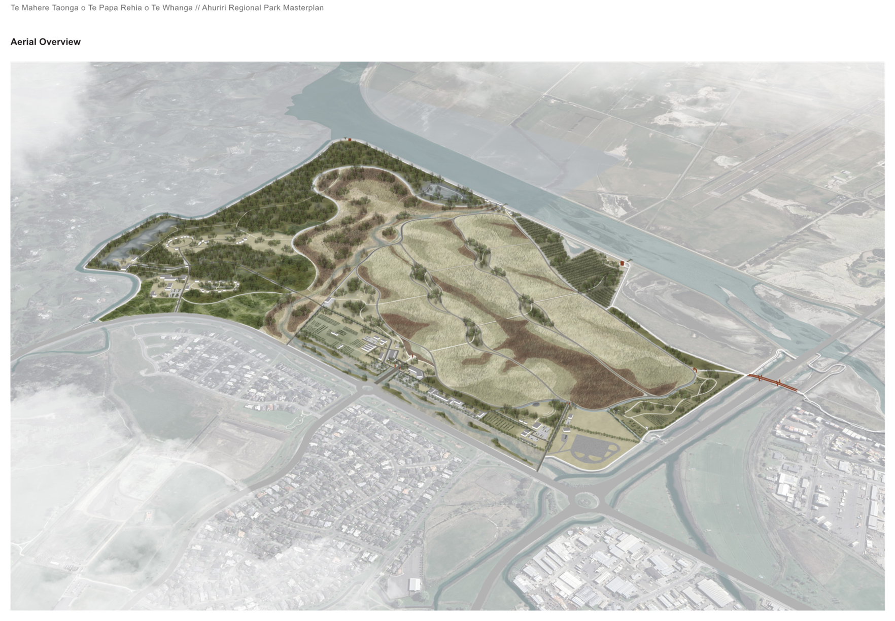
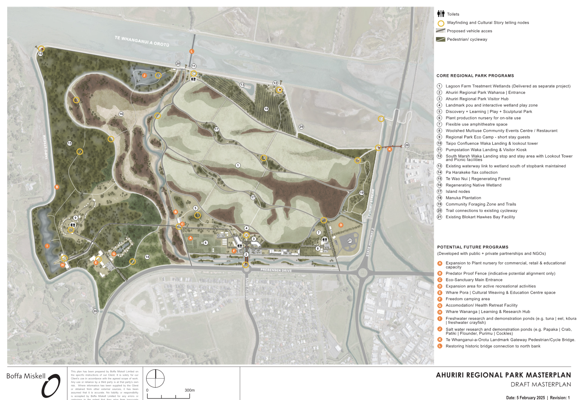
The Concept Design for public feedback has been included as Attachment 1 (Doc Id 1831536).
Key elements within the masterplan concept that are proposed to be developed as part of the core development program are listed below.
Stormwater Wetlands
The masterplan has adopted the largest currently viable area for stormwater treatment. The treatment facility, shown as wetlands, is being delivered through a separately funded project the Lagoon Farm Stormwater Diversion Project.
The masterplan has been shaped around the engineering requirements to site the proposed Lagoon Farm treatment wetlands on the highest part of the site to allow gravity fed flow through the wetlands. The system will receive water pumped from the Pūrimu channel on the eastern boundary that will flow through a series of up to six flow channels though densely planted wetlands. Urban pollutants and excess pollutants will be captured before the cleansed water overflows from the western end of the wetland cells into the wider drainage system that is picked up by the Lagoon Farm pump station and discharged to the estuary.
An access road will surround the wetland cells offering operational access and recreational access for pedestrian and cyclists.
The proposed planting patterns use contrasting foliage to form bold patterns within the wetlands that reference the forms of sandbanks and channels captured in historic maps of the former lagoon.
The final shape and form of the wetlands may vary from that depicted in the masterplan so it will be essential to allow for a degree of flexibility in the masterplan implementation to adapt to this.
Ahuriri Regional Park Waharoa | Entrance
The primary site entry is off the existing Prebensen / Orotu Drive roundabout across the Prebenson Drive Reserve channel. This is envisioned as a landmark bridge or culvert crossing with a strong axial viewshaft into the proposed Lagoon Farm treatment wetlands to form the primary waharoa / entry to the park.
Ahuriri Regional Park Visitor Hub
The Regional Park Visitor Hub is orientated around central landmark Pou and plaza space facing an interactive wetland play zone. The buildings wrapping around the open space area could be phased initially as a simple shelter with static information and signage. In the long term this can be replaced or complemented with a purpose designed visitor education and discovery centre that provides a range of spaces for displays and exhibits telling the cultural and natural histories of the park and wider Te Whanganui a Orotū landscape.
A second building to the east would accommodate other compatible uses such as museum or tertiary education outreach space, research, consulting, tourist and visitor services. Supporting this will be seating, picnic tables and shelters. The proposed location is on the higher part of the site than therefore more resilient to current and future flood risks.
There are complementary opportunities for partnerships such as a cafe, gift shop and multi-use community spaces.
Discovery + Learning | Play + Sculptural Park
To the east of the visitor hub excess materials from the wetland construction would be sculpted into a series of mound to form ’island’ formations with clusters of trees for shade and biodiversity values set amongst a native shrubland and periodically mown meadow areas. Set within this will be pathways linking several nature-play zones potentially incorporating and Māra Hūpara (Māori play activities).
Additional sites for sculptural art are available in this zone and could form the nucleus for a park wide sculptural trail.
Plant production nursery for on-site use
Part of the commercial opportunities identified is a Native Plant Nursery, in the first stage this would be aimed at supplying onsite planting needs through eco-seed sourcing. This may be an iwi or community managed operation or could be leased back to an existing operation.
As a second stage it is suggested that this could be expanded to supply wholesale and retail markets with potential of research and training opportunities. This could include an agri-solar component where plant production is undertaken amongst and under solar panel arrays.
Flexible use amphitheatre space
To the east of the Visitor Hub a grassed amphitheatre area is proposed adjacent to the existing Lagoon Farm Woolshed complex that can host a variety of community events.
Existing and supplementary trees will screen and shelter this area from the east and south while allowing for views out over the treatment wetlands to the Poraiti Hills. Turf areas may require treatment with bird deterrent inoculants to reduce the attractiveness to waterfowl and other species that present a higher risk to airport operations. The positioning of this aspect is outside of the flight path zone and offers a cluster of human activity nearby the woolshed.
Woolshed Multiuse Community Events Centre / Restaurant
A renovated and repurposed woolshed building provides opportunity for a community events centre that will complement the amphitheatre space. This could include opportunity for a restaurant/brew bar operation celebrating food and materials grown in adjacent gardens and gathered from the wider park space and the greater region. We anticipate that this could be delivered through an external partner.
Regional Park Eco Camp - Short Stay Guests
Offering a unique experience of staying in a wilderness on the doorstep to the City the masterplan provides for a space aimed at short term stays, catering to visitors, school and community groups such as scouts.
This is modelled on similar facilities within in other regional parks around the country and is intended to offer the opportunity to be immersed in learning and experiences around regeneration of the native ecosystems, matauranga māori, mahinga kai practice and potentially participate in restoration activities. This would be particularly special should a wildlife sanctuary be established this will allow guests to experience staying amongst a variety of native birds, lizards and invertebrates.
Waka Landing & lookout tower
An opportunity for a landmark tower is proposed to mark the confluence of the Ahuriri channel with the Taipo. This would allow visitors to gain sufficient elevation to view out over the proposed forest and wetland areas within the site and fully appreciate the scale of the project as well as viewing opportunities over the wider Ahuriri plains to the north. Complementing this is a proposed waka landing that allows paddlers to journey up the estuary to visit this part of the Park at high tide.
Pumpstation Waka Landing & Visitor Kiosk
Adjacent to the existing pump station a waka landing is proposed to provide a point for kayakers, canoes and waka to arrive to the site. On the landward side of the stop bank a kiosk shelter with information will welcome and guide the visitors in exploring the wider park.
South Marsh Waka Landing stop & stay area with Lookout Tower & Picnic facilities
East of the existing South Marsh zone a third waka landing is proposed to offer landing options with a picnic area with shelters and tables and a second lookout tower focused on bird watching opportunities. The landing will provide an opportunity for whānau to swim in the channel during higher tides.
Existing waterway link to wetland south of stopbank maintained (14)
A small area of existing wetland lies outside of the Park boundaries will be maintained though preserving the existing channel that connects back to the Lagoon Farm Pump Station.
Pa Harakeke flax collection (14)
Bordering Prebenson Road to the west of the park is a large area identified for a future collection of Harekeke | Flax that can be utilised for traditional weaving arts. This would be structured with access trails and, where appropriate, interpretation information. A biodiverse arrangement of shrubs interplanted with areas of harekeke will be utilised to increase ecological value and reduce attraction of large flocks of starlings that are identified as a risk species for the airport operations.
Te Wao Nui | Regenerating Forest (15)
Concentrated on the western side of the park are extensive areas of te wao nui |(regenerating forest). The ambition is to support development of Kahikatea / Pukatea Forest that can tolerate occasional flooding and support ongoing mahingakai activities including Tōtara for long term use for whakaaro (carving & waka), and plants for rongoā (medicine).
Regenerating Native Wetland (16)
Working with the existing slow lying topography in the north-western corner of the site, an expansive wetland plain is proposed to be created through shallow regrading of the existing drains and surfaces. This will be supported by the additional water from the treatment wetlands and periodic inundation when large flows pass through the site via the Prebenson Channel. Open water will be minimised, and dense plantings of reeds, flax, shrubs and trees are proposed to reduce habitat attractiveness for waterfowl and wading birds that pose the most risk for airport operations.
Island nodes (17)
Island nodes within the centre of the treatment wetlands will be formed from excess fill from the wetland construction to form vegetated mounds. These provide a contrast to the landscape of massed reeds and rushes offering both elevated viewing points and references to the landforms within the historic Ahuriri Lagoon. Water distribution berms across the wetland cells will be used to support boardwalk or pathway crossing points for pedestrians and cyclists. Shelters and sculptures can be accommodated within the islands.
Manuka Plantation (18)
On the northern boundary of the treatment wetlands a large area of manuka dominated planting is proposed to provide a low hardy vegetation cover for this part of the site with opportunity for harvest of oils and honey. It will be interspersed with bands of herbaceous low flammability planting for added biodiversity value and fire risk mitigation.
Community Foraging Zone and Trails (19)
Along the eastern boundary of the park the area between the Purimū and Treatment Wetlands provide a productive land use opportunity with plantings of fruit, nut and other food producing plant species. More intensive areas of urban agriculture could be provided within this zone as lease opportunities for small scale urban farmers supporting local markets, stalls or vegetable box subscriptions. This area will accommodate public trails and visual interest for viewers passing along the highway corridor.
As this lies within a NZTA designation long term restoration or wetland treatment infrastructure have not been proposed in this area.
Trail connections to existing cycleway (20)
Multiple connections from the existing cycleway into the site are proposed with linkages to pedestrian/cycle pathways within the park. A clear hierarchy will be developed to delineate what trails accommodate pedestrians only versus multiuse trails that can accommodate cyclists, pedestrians and maintenance vehicles.
Existing Blokart Hawkes Bay Facility (21)
The existing lease for the Blokart course sits partially within the NZTA designation and is proposed to be retained as an active recreation opportunity that complements the wider park programs.
Located adjacent to the existing Blokart facility this land is identified as an expansion opportunity for further active recreation activities. This could be a additional Blokart course or other complementary activities.
General Park Facilities
· Sculpture and Art Features - There is an opportunity to use the wider park as a setting for a variety of sculptures and Landart elements that celebrate the cultural and natural character of the area, both historic and future. This program could be managed separately from the park construction with philanthropic organisations to commission pieces.
· Site wide wayfinding and interpretation signage - A distinctive and cohesive signage system will guide visitors through the park, offering curated experiences while sharing the site's history and restoration journey. This will include a mix of physical signage and digital media to enhance storytelling and engagement.
· Visitor amenities - Seating, shelters, toilet facilities, and information kiosks will be strategically placed to enhance the visitor experience. In key gathering areas, such as the visitor hub, additional amenities like BBQ and hangi facilities may be included for public use.
· Tree planting for shade and shelter - Establishing shade along key pathways and circulation routes will be a priority. A strategic planting approach will combine fast-growing native and exotic species to create immediate canopy cover, with slower-growing trees introduced over time to ensure long-term sustainability and biodiversity.
Potential Future Programs (A – L)
A range of additional potential future programs are identified on the masterplan. These will require further detailed business case studies and would be expected to be developed and managed under public + private partnerships and other non-government organisations. These opportunities include:
· Expansion of the plant nursery for commercial, retail or educational purposes,
· Predator proof fencing,
· Expansion of active recreational activities,
· Whare Pora | Cultural Weaving and Education Centre,
· Freedom camping,
· Whare Wananga | Learning and Research Hub,
· Freshwater research and demonstration ponds,
· Saltwater research and demonstration ponds,
· Landmark gateway pedestrian/ cycle bridge
· Restoring historic bridge connection to the north
2.3 Issues
Analysis of the commercial viability for the conceptual programs, facilities and activities shown in the masterplan will need to be reviewed in detailed business cases. This may lead to changes in the phasing and changes to scale and composition to elements such as the complementary commercial activities. The masterplan, park zoning and management plans will need to be structured to be flexible enough to allow this adapted approach.
The preliminary opinion of cost provided as part of the masterplan is based on landscape architectural pricing and will need to be verified by a quantity surveyor with expertise in the Hawkes Bay market. The pricing does not include the Lagoon Farm treatment wetland and there could be some overlap in these budgets.
The airport operations remain a key constraint on the site as the flightpath aligns with the proposed primary entry area. The noise of flights using the flightpath could be disruptive to the enjoyment of these programs and will need to be managed in the acoustic design of future buildings.
A landscape management plan for the park prepared in consultation with the Airport is required to ensure planting, wetlands, lawn areas and waste are managed appropriately to minimise high risk bird species use of the site. This will likely need to be integrated into a future reserve management plan.
Reflective surfaces from buildings or solar panel installations would need to be assessed for glint and glare effects on airport operations.
The masterplan design will need to be flexible and adaptable to allow for variation to staging in response to funding availability and changes to the design of the treatment wetland system.
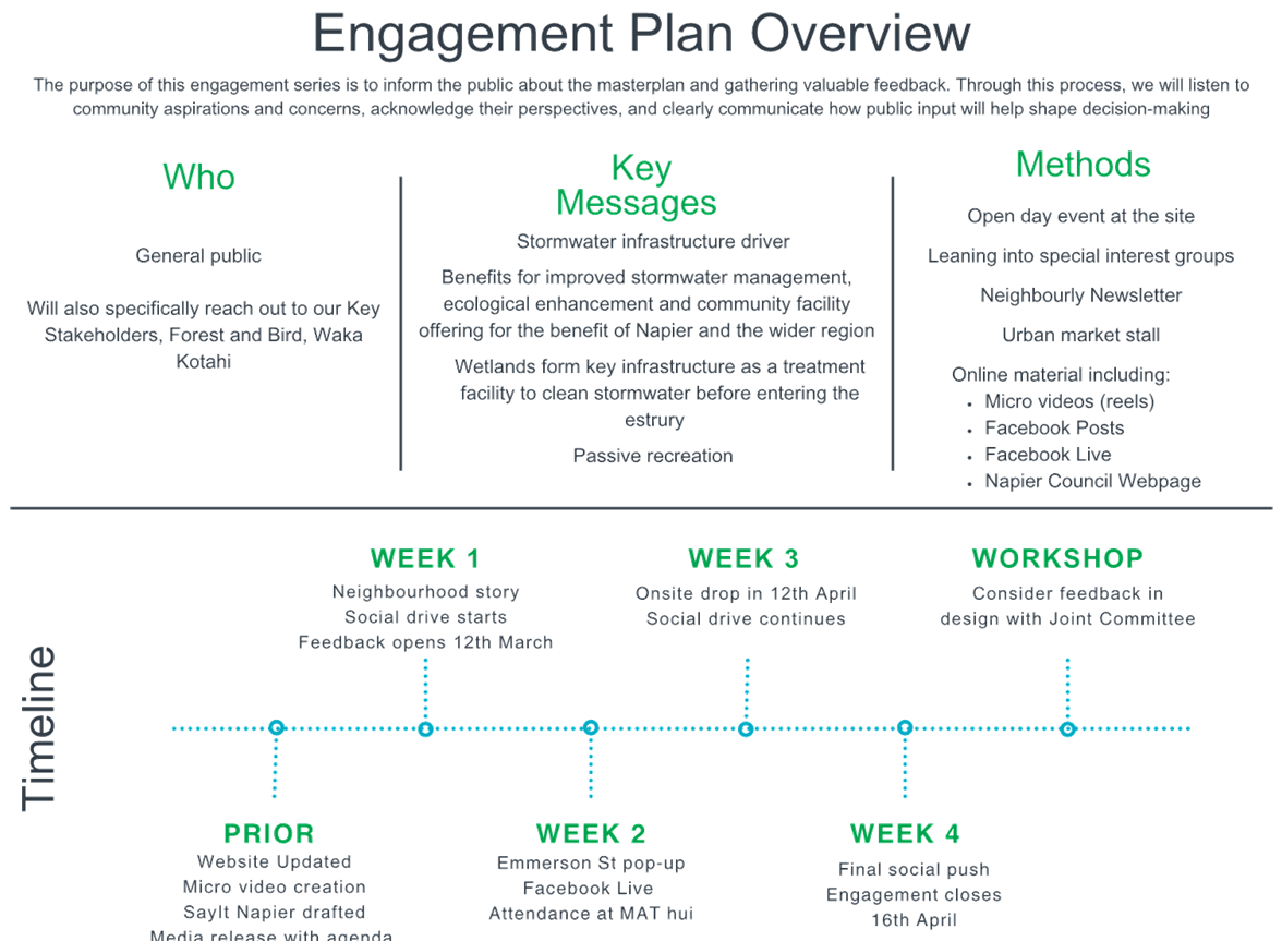
2.4 Significance and Engagement
The development of the masterplan continues to algin with the approved engagement approach.
A one-page engagement overview is provided in Attachment 2 (Doc Id 1831535), outlining the upcoming public consultation process. In summary:
· Engagement period: March – April 2025
· Engagement methods:
- Digital channels: Micro videos, Facebook posts, Facebook Live sessions, and updates on the Napier Council website
- Community outreach: Article in the Neighbourly newsletter and messaging on Napier Council digital screens
- In-person event: Open day at the farm (tentatively scheduled for 12 April, 10 AM – 12 PM)
- Targeted engagement: Direct letters to key stakeholders and community champions.
· Key messages focus on:
- Core infrastructure requirements,
- Improving stormwater quality before it enters the estuary,
- Multi-benefit opportunities, including cultural narratives, ecological enhancements, and community opportunities.
Although the second design hui with Mana Ahuriri Trust was unfortunately cancelled, the masterplan has been shared with project partners for feedback ahead of the public engagement process.
2.5 Implications
Financial
Public feedback has been programmed into the overall masterplan budget. We remain on track with expenditure.
Social & Policy
The Technical Advisory Group will communicate progress to the project partners and the key stakeholders will be updated via a newsletter containing an update and an invitation to the onsite open day event.
Risk
Risk Matrices have been developed for the broader project and the Master Plan design exercise. These are regularly monitored by the project team and reported to NCC officers on a monthly basis.
Key risk in response to this decision is that in the event that an option is not pursued to concept design, we may experience a program delay which could result in the final masterplan not being ready for endorsement prior to the local government elections.
2.6 Options
The options available to Council are as follows:
a) Endorse the Concept Design Ahuriri Regional Park Masterplan for public engagement.
b) Endorse the Concept Design Ahuriri Regional Park Masterplan for public engagement with amendments.
c) Not endorse the Concept Design Ahuriri Regional Park Masterplan for public engagement.
2.7 Development of Preferred Option
N/A
1 Draft Master Plan for public feedback (Doc Id 1831536)
Ahuriri Regional Park Joint Committee
Open Minutes
|
Meeting Date: |
Monday 9 December 2024 |
|
Time: |
11.30am – 12.05pm |
|
Venue |
Breakout Room 2 |
|
Present: |
Chair: Deputy Mayor Brosnan (NCC) Councillor Price (NCC) Councillor Ormsby (HBRC) Peter Eden and Joseph Reti (Deputy Chair) (Mana Ahuriri Trust) |
|
Also present: |
Councillors Browne (Alternate) and Crown |
|
In Attendance: |
Napier City Council - Executive Director Infrastructure Services (Russell Bond) - Executive Director City Strategy (Rachael Bailey) - Strategic Planning Lead (Connie Mills) - Principal Planner Policy (Fleur Lincoln) - Manager Water Strategy (Phil Kelsen) - Acting Manager Environmental Solutions (Sarah Bowler) - Parks Policy Planner (Amelia Longley) [via Zoom]
Hawke’s Bay Regional Council: - Regional Park Planner (Bart Leslie) - Team Leader Asset Planner (Johan Kirsten) [via Zoom] Consultants: - Cameron Drury (Stradegy) - William Hatton (Boffa Miskell) [via Zoom] - Greig Wilson (Beca) [via Zoom] - Rebecca Ryder (Boffa Miskell) [via Zoom] |
|
Administration |
Governance Advisor (Carolyn Hunt) |
Ahuriri Regional Park Joint Committee – Open Minutes
Table of Contents
Order of Business Page No.
Karakia
Apologies
Conflicts of interest
Public forum
Announcements by the Mayor
Announcements by the Chairperson
Announcements by the management
Confirmation of minutes
Agenda Items
1. Project Manager's Update
2. Endorsement of Option to Concept Design
Minor matters
Order of Business
Mr Reti opened the meeting with a karakia.
|
Deputy Mayor Brosnan / Councillor Hinewai Ormsby That the apologies for absence from Councillors Williams and Kirton (HBRC) and Evelyn Ratima (MAT) be accepted. Carried |
Conflicts of interest
Nil
Nil
Announcements by the Chairperson
MAT Alternate Appointment – The Chair advised that with the appointment of Evelyn Ratima to the Ahuriri Regional Park Joint Committee as a Committee member a new alternate for Mana Ahuriri Trust was required.
Mana Ahuriri Trust to advise of a new alternate appointment to the Committee.
Announcements by the management
Nil
|
Joseph Reti / Councillor Price That the Ahuriri Regional Park Joint Committee Minutes of the meeting held on 19 August 2024 were taken as a true and accurate record of the meeting.
Carried |
|
Type of Report: |
Information |
|
Legal Reference: |
N/A |
|
Document ID: |
1814873 |
|
Reporting Officer/s & Unit: |
Connie Mills, Strategic Planning Lead
|
|
1.1 Purpose of Report The purpose of this report is to provide a Project Managers update. |
|
At the meeting The Project Manager, Mr Drury spoke to the report providing a summary and overview of the progress made over the period mid-August to November 2024. Mr Drury recognised that due to the hikoi for the Treaty Principles Bill during November, mana whenua had not been able to participate in the hapū design wānanga. A rescheduled design hui is being organised to occur prior to the preferred concept being progressed to concept design. The Chair commented that Mr Drury and Ms Mills had done a great job in presenting the project stage progress to the Hawke’s Bay Airport when they met with the operational team to discuss environmental and bird-strike issues. Bird-strike is one of the strategic risks to the project and it was felt that all the constraints were well in-hand with the expertise that the team have on board and was very collaborative towards a solution. As an outcome of the meeting a draft monitoring and maintenance plan was to be developed in co-ordination with the Hawke’s Bay Airport. |
|
|
Committee resolution
|
Councillor Ormsby / Joseph Reti The Ahuriri Regional Park Joint Committee: a. Receive the report titled “Ahuriri Regional Park – Project Update” dated 9 December 2024. Carried |
2. Endorsement of Option to Concept Design
|
Type of Report: |
Procedural |
|
Legal Reference: |
N/A |
|
Document ID: |
1814874 |
|
Reporting Officer/s & Unit: |
Connie Mills, Strategic Planning Lead |
|
2.1 Purpose of Report This report seeks endorsement of a design option to proceed to concept design for the Ahuriri Regional Park masterplan.
Further, it seeks to delegate approval of the preferred design option to the Chair, subject to engagement with Mana Ahuriri Trustees. This will enable progressing with the masterplan and avoid delays. |
|
At the meeting The Strategic Planning Lead, Ms Mills spoke to the report advising that the workshop held prior to the meeting had provided in-depth discussion on design considerations and key park components such as the location of wetlands, the softening of stopbanks, access points, and activities that support avifauna. The size and placement of the stormwater treatment wetlands, in particular, have had a substantial impact on the overall park design. Endorsement from the Committee was sought for Option 2 – “Interwoven Land Use” to develop a full concept design. At the stakeholder meeting Options 2 and 3 were overwhelmingly favoured. Upon revision Option 2 is the preferred option. Following discussion the Committee were comfortable with Option 2 provided the following aspects are addressed: · predator proof fencing is provided for recognising that this is a long term project and may be implemented at a later date. · the largest wetland area is provided for to enable the maximum treatment opportunity for incoming stormwater from the Old Tutaekuri River Bed. · Combining people centric and communal spaces where practical. · Reducing car travel in the Park. · the entrance stands out, giving a welcoming experience into the Park similar to a waharoa. · Recreational walking tracks for all walking abilities. . The Acting Manager Environmental Solutions Ms Bowler advised that the report from Tonkin + Taylor in regard to confirmation of site constraints, wetland sizing and location was anticipated to be released at the end of this week. Ms Bowler advised that on receipt of the report a copy would be circulated to all Committee members for information. The Executive Director Infrastructure, Mr Bond advised that Council have a joint stormwater discharge consent with the Hawke’s Bay Regional Council (HBRC) and any work within the programme would need to involve the HBRC. The joint consent requires a variety of treatment options be investigated throughout the catchment and the Water Team have been working on the complexities in delivering this, it is currently in the monitoring phase. The team may be able to provide a picture on what projects are currently occurring to give effect to the directions set by the joint consent. As these solutions involve both Councils and is needed to be co-funded, a definitive timeline on when and how these solutions are being delivered may not be available. The Chair advised, for this project to be successful, it is becoming clearer that a whole of network approach is required to get the best water quality outcome. The Committee agreed that a paper from the Sustainable Napier Committee would provide Committee members an update on what is happening throughout the network with stormwater quality, highlighting that the ARP is one facility in the wider works programme and consideration of stormwater quality action plan upstream of the ARP. |
|
|
Committee resolution
|
Councillor Ormsby / Peter Eden The Ahuriri Regional Park Joint Committee: a) Endorse Option 2 – ‘Interwoven Land Use’ to develop a full concept design. b) Delegate the responsibility to approve the final design option, prior to preferred concept design, to the Chair provided the following is addressed: i. Re-confirm the Ahuriri Regional Park Joint Committee’s core vision to treat all currently untreated stormwater entering te-whanga. ii. Note the direction feedback from the Ahuriri Regional Park Joint Committee workshop held on 9 December 2024 as follows: - Predator proof fencing - Availability of wetland area - People and communal spaces - Car travel - Wahoroa / entrance way - Walking abilities. iii. Note officers will report back to the 17 February 2025 Committee meeting, recommendations from Tonkin and Taylor regarding the incoming stormwater solution for the OTRB Old Tutaekuri River Bed (OTRB) catchment. iv. Recommend to the Sustainable Napier Committee that they consider the development of an upstream stormwater treatment action plan, pre discharge in to the Ahuriri Regional Park (ARP), to address water quality improvements in the catchment, and flag the importance of these works on the successful delivery of the ARP end-of-line treatment. Carried |
Next Steps – Ms Mills advised that the design team, Boffa Miskell will be developing the design further so that at the meeting on 17 February 2025 it will look like a Master Plan with today’s modifications.
Prior to February 2025, a second design hui will be arranged with Mana Ahuriri to ensure that the design components are aligned with their aspirations and considered well throughout this project, noting there maybe some design alterations as an outcome.
The next Joint Committee meeting in February 2025 will be seeking to receive endorsement from the Committee to go out for public feedback. During the public feedback process further design alterations may occur.
At the 23 May 2025 meeting the Committee will be presented with the final Master Plan.
At the conclusion of the meeting the Chair acknowledged and thanked officers, supporting team and Committee on the fantastic progress of the project this year, and also gaining consensus with the stakeholders.
The Chair wished everyone a Merry and safe Christmas.
Mr Reti gave the closing karakia with the meeting closing at 12.05pm
|
Approved and adopted as a true and accurate record of the meeting.
Chairperson ......................................................................................................................
Date of approval ............................................................................................................... |