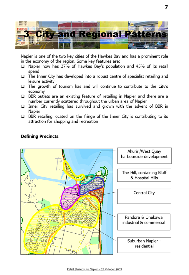
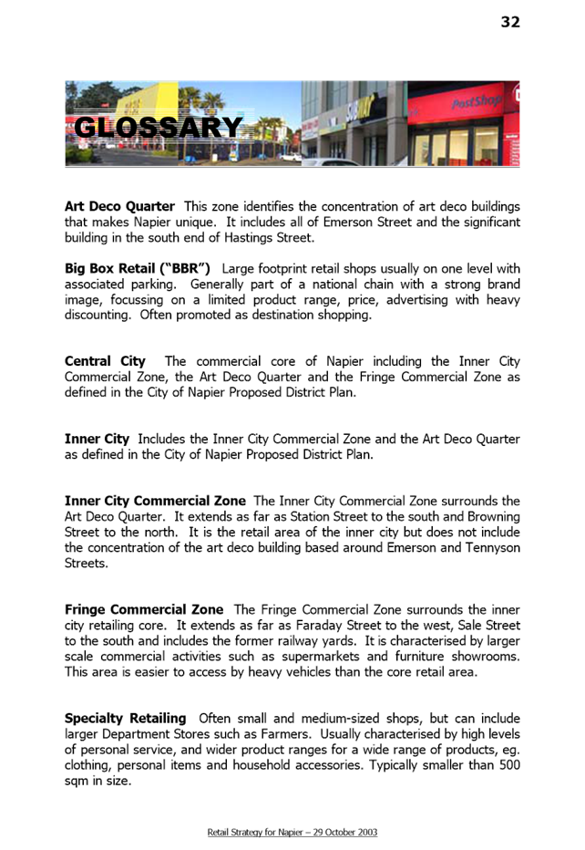
 NAPIER
CITY COUNCIL
NAPIER
CITY COUNCIL
Civic Building
231 Hastings Street,
Napier
Phone: (06) 835
7579
www.napier.govt.nz
Strategy
and Infrastructure Committee
Open
Agenda
|
Meeting Date:
|
Wednesday 31 May 2017
|
|
Time:
|
3pm
|
|
Venue:
|
Main Committee Room
3rd floor Civic Building
231 Hastings Street
Napier
|
|
Council Members
|
Councillor
Price (In the Chair), the Mayor, Councillors Boag, Brosnan, Dallimore, Hague,
Jeffery, McGrath, Price, Tapine, White, Wise and Wright
|
|
Officer Responsible
|
Director
Infrastructure Services and Director City Strategy
|
|
Administrator
|
Governance
Team
|
Next
Strategy and Infrastructure Committee Meeting
Wednesday
19 July 2017
Strategy and Infrastructure Committee – 31 May 2017 – Open Agenda
ORDER OF BUSINESS
Apologies
Nil
CONFLICTS
OF INTEREST
Public
forum
Dr Charles Daugherty (Chair – Hawke’s Bay
Biodiversity Implementation Planning Group) – presentation
Announcements
by the Mayor
Announcements
by the Chairperson
Announcements
by the Management
Confirmation
of Minutes
That
the Minutes of the Strategy and Infrastructure Committee meeting held on
Wednesday, 19 April 2017 be taken as a true and accurate record of the meeting.
Notification
and Justification of Matters of Extraordinary Business
(Strictly for information and/or referral purposes only).
Agenda
Items
1 Retail
Strategy........................................................................................................................ 3
2 Heritage
Improvement Grant Administration Changes....................................................... 43
3 Clifton
to Tangoio Coastal Hazards Strategy 2120 - Progress Update ............................. 49
4 Land
legalisation - 2 Hastings Street & 12 Browning Street, Napier.................................. 64
Public
Excluded
Nil
Minutes
19 April 2017...................................................................................................................................... 67
Strategy and
Infrastructure Committee – 31 May 2017 – Open Agenda
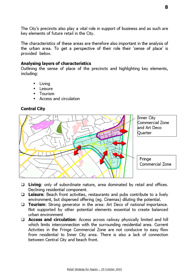
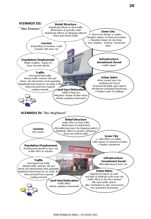
1. Retail Strategy
|
Type of Report:
|
Enter Significance of Report
|
|
Legal Reference:
|
Enter Legal Reference
|
|
Document ID:
|
354524
|
|
Reporting Officer/s & Unit:
|
Dean Moriarity, Team Leader Policy Planning
|
1.1 Purpose
of Report
The purpose of this report is for
Council to acknowledge its existing Retail Strategy, confirm its philosophical
approach as still sound, and to authorise officers to review the strategy to
ensure it remains fit for purpose for the next several years.
|
Officer’s Recommendation
That Council
a. Acknowledge
that the basic philosophical approach and strategic direction of the existing
Retail Strategy (2003) remains fundamentally sound and
b. Authorise
a review of the existing Retail Strategy, including a seminar for elected
members, to ensure it remains ‘fit for purpose’ whilst noting the
intention to retain the current overall strategic direction.
|
|
CHAIRPERSON’S
RECOMMENDATION
That the
Council resolve
that the officer’s recommendation be adopted.
|
1.2 Background Summary
The rapidly changing dynamics of
retailing in the early 2000’s, in particular the rapid growth and
expansion of large format retailing (‘LFR’), resulted in the Napier
City Council taking a proactive approach towards providing for the long term
retail needs of the City.
A retail strategy working group was
established made up of Councillors, stakeholders, interest groups and staff and
a series of workshops held with several rounds of consultation undertaken,
before Council adopted its Retail Strategy in October 2003. A copy of the
Strategy is shown at Attachment A.
The Retail Strategy sets the direction
of consolidating the strong links between the inner city commercial centre,
(incorporating the iconic art deco building resource, accommodating mainly
specialty retailing), and the fringe commercial area supporting a range of
commercial uses including retailers needing larger footprints. However,
the Strategy also recognises that the current commercial zoning has limitations
in providing for the scale of development demanded by some large format
retailers, and to this end separate provision was made for them in an area of
the City where the appropriately sized land holdings were available.
The Strategy ultimately involved a plan
change to the District Plan, to introduce a new (LFR) zone that specifically
caters for large format retail development along Prebensen Drive that aimed to
limit adverse effects on the cultural heart of the City, as well as industry
which were at the time competing for sites with LFR.
The three key aspects associated with
large format retailing that were identified as affecting the sustainability of
the natural and physical resources of the City, were:
§
The
Effects on the Historic and Cultural Art Deco Building Resource; and
§
Sustainable
Growth of Industry; and
§
Accessibility
of Large Format Retailing
Art Deco Building Resource
Large format retailing demands larger
buildings and larger land holdings and as such poses a threat to the existing
art deco building resource. LFR is attractive to shoppers and in order for the
existing art deco commercial centre to maintain its share of the retail dollar
the two retail sectors need to complement one another. Ideally this would be
achieved by locating individual LFR developments around the edge of the art
deco quarter of the city. In this regard there has been some success to
date in Napier although the ability to achieve the required land holdings to
accommodate the larger areas of land required is difficult.
Sustainable Growth of Industry
In order to obtain sufficient land for
large format retailing, developers have previously made resource consent
application to use industrially zoned land at Pandora on the main arterial
route north from the City. This area of the City has traditionally been the
preserve of large industries, but the ability to obtain large sites for a
relatively low cost proved highly attractive to developers trying to put a
package together for multiple large format retailers to operate in a single
destination.
The Large Format Zone in the District
Plan was designed to cater specifically for the larger retail developments so
that they did not need to compete with industrial activities on land designed
and serviced for industrial needs.
Accessibility
One of the major issues for
consideration in large format retailing is the accessibility of the site. It is
important for the development to be located at a prominent location to ensure
that it is highly visible and also to assist in mitigating the effects of the
traffic attracted to the development, on the road network.
One of the issues that is recognised in
the Retail Strategy as being critical to reducing the impacts of LFR on the
existing inner city commercial environment is the linkages between the two
areas. As previously discussed the ideal would be to locate LFR development on
the fringe of the commercial centre. However, this cannot be comprehensively
achieved in all cases and therefore the Large Format Retail zone does need to
be as accessible to the inner city area as possible.
Prebensen Drive is one of the main arterials
into the city with a relatively unencumbered route to the city centre. It
also has the advantage of having direct links to the Hawke’s Bay
Expressway. The Retail Strategy identified that the travel times between
the LFR Zone and the inner city facilitated opportunities for cross shopping
between the two separate locations.
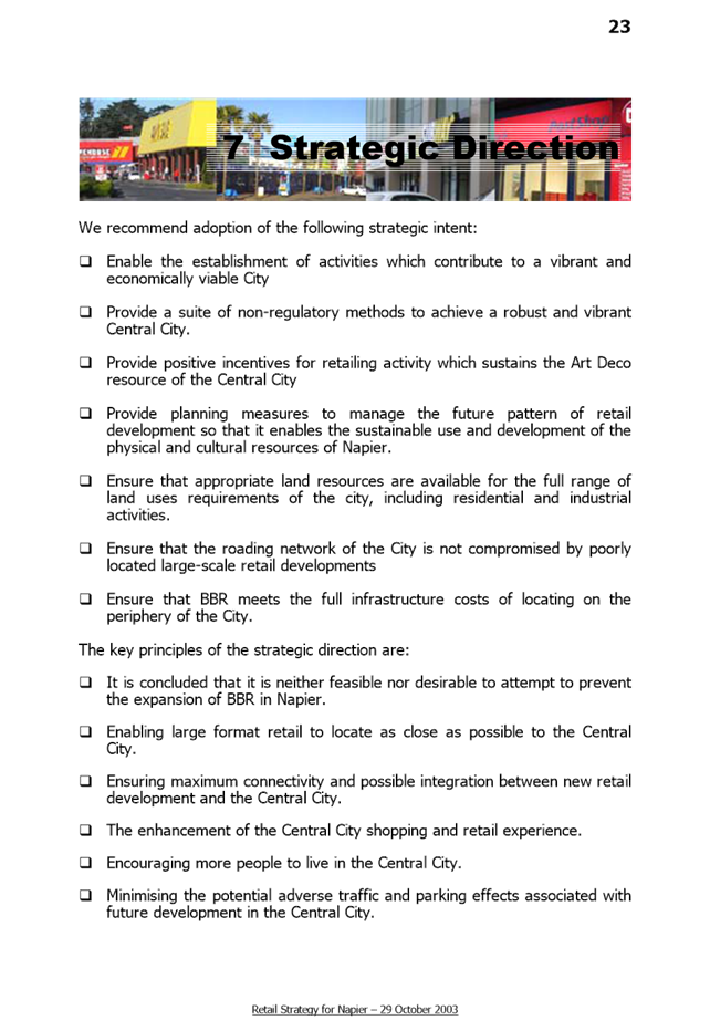
Key Principles and Recommendations of
the Strategy
Ultimately the Retail Strategy proposed
a large number of recommendations for how to take a strategic approach to
accommodate all forms of retailing within the city so as to derive the maximum
benefit for the city and its people by sustainably managing all of its natural
and physical resources. The key principles and recommendations involve a
wide ranging combination of methods (many of which are non-regulatory)
including (but not limited to):
– Enabling
an efficient, competitive and innovative retail sector through effective
planning and governance
– Ensuring
that the location of retail activities leads to efficient use and development
of the City’s resources
– Maintaining
and enhancing the high levels of amenity enjoyed by the residents and visitors
to Napier
– Recognising
and protecting the Art Deco heritage values of the City by ensuring that future
retail activities complement and maintain these values
– Enabling
large format retail to locate as close as possible to the Central City
– Ensuring
maximum connectivity and possible integration between new retail development
and the Central City
– Enhancement
of the Central City shopping and retail experience
– Encouraging
more people to live in the Central City
– Minimising
the potential adverse traffic and parking effects associated with future
development in the Central City
To give effect to these key principles
the primary regulatory response recommended in the Strategy (and which was
adopted as part of the LFR Zone Plan Change) was for LFR developments outside
of the central city:
– Individual
tenancies have a minimum floor area of 500m2 and
– At
least 75% of tenancies have a floor area of equal to or greater than 1,000m2.
– Café
and /or lunch bar ancillary to, on the basis of a maximum of one such facility
per 10,000m2 of floor area.
– Encourage
LFR to locate on arterial roads with appropriate access arrangements.
– Provide
for appropriate parking.
1.3 Issues
Two types of LFR have been identified,
the “fast and high” turnout LFR represented by supermarkets, or
other chains such as Kmart and the “slow or low” turnout of goods
such as furniture suppliers or boat retailers. Despite both types being
recognised as destination retail and being a significant draw to the retailing
public, it is the fast turnout LFR that could potentially adversely affect the
vitality and viability of Napier CBD if not carefully located. In addition, if
the LFR manages to also attract a cluster of specialty shops as seen in
Hamilton then the negative impact on the main retail centre is worsened.
The negative effects for Napier arises
from the potential withdrawal of businesses from the inner city. The inner city
has art deco buildings purposely built for smaller specialty shops who could be
attracted to collocate around the fast LFR outside the CBD if allowed. This
would also disperse new investment and employment away from the city
centre.
Maintaining some level of control over
the type of development within the Large Format Retail Zone is one of the most
important means of maintaining the viability of the inner city commercial area.
The Resource Management Act clearly states that market competition is not an
issue that may be considered. However, it is recognised that small specialty
shops seek to cluster around large format development and that traditional
commercial areas suffer as shop owners relocate to the new development. The
Hastings LFR Precinct is provided as an example of the potential to consider a
regional approach to some large format retail offerings (see Attachment B) in
order to avoid negative impacts on the Napier CBD.
The other issue with LFR locating
outside of the centre of town is allowing major traffic generators (e.g. a
supermarket) to establish as a permitted activity in any locality as the
effects associated with such activities (primarily traffic generation) can be
significant unless those effects can be mitigated. It is for this reason
that the LFR Zone includes a cap on the number of carparks (as a proportion of
floorspace) that can be provided as part of an LFR offering to qualify as a
permitted activity, as does any new access onto an arterial road. LFR
operations wanting to provide new access arrangements directly off an arterial
road or those wishing to provide more parking spaces than the maximum require
resource consent. This allows Council to retain discretion to consider the
appropriateness of the activity establishing in such a location.
Review of the Retail Strategy
The purpose of the Retail Strategy is to
provide the Napier City Council, local retail sector, potential retail
investors and other retail interests with a suitable City-wide resource
management and planning guide for their respective roles in relation to
considering new retail development proposals for the City. In particular
the strategy is intended to provide the Napier City Council with a structured
framework for assessing future resource consent applications in respect of retail
developments.
As the existing strategy has played a
valuable role in the growth and development of Napier’s retail sector
over the past decade, it is considered that an updated version should continue
to provide a broad policy reference point that remains fit for purpose for the
next several years. As alluded to above a number of the retail issues,
policies and actions advocated in the existing strategy remain very relevant
today.
Work has already begun on reviewing the
existing retail strategy with the intention to include: the wider city
strategic development context, city and retail sector economic trends, Napier
District Plan retail sector requirements, the current profile of retailing in
Napier, retail sector growth challenges for the future, the long-term economic
growth outlook and future growth and development considerations for the sector.
It is also proposed to assess the retail offerings at a regional level and
explore whether there is an opportunity for Hastings and Napier to provide for
specific niches which could be complementary.
Once the review of the existing Retail
Strategy has been completed and a new Draft Retail Strategy developed we
suggest presenting this to Councillors at a seminar and thereafter circulate to
all relevant stakeholders and interested people for comment and feedback before
the final Retail Strategy is reported back to Council for adoption.
1.4 Significance and Consultation
As identified above it is intended to
undertake a consultation process with key stakeholders and other interested
parties before finalising the Strategy. Given that it is a review of an
existing strategy rather than the development of a new one (and assuming there
are no radical regulatory changes proposed) the scope of engagement will be
relatively narrow in focus but opportunity will be provided for interested
parties to comment in order to obtain feedback on the content.
1.5 Implications
Financial
The review of the Retail Strategy can be
accommodated within operational budgets.
Social & Policy
No substantial social or policy
implications have been identified as a result of the review of the existing
Retail Strategy, but if any emerge they can be reported back to Council prior
to adoption of the final Strategy.
Risk
The risk to Council centres primarily
around not reviewing the Retail Strategy.
The Retail Strategy is an important
policy document that has helped shaped the retailing landscape in Napier since
the early 2000’s and assisted in Napier retaining a vibrant compact
retail heart within its existing CBD. A strategy that promotes and
supports specialty retailing in the centre of town supported by larger
retailing offerings in close proximity is essential for maintaining the Napier
CBD as the premier specialty retailing destination for the whole of the East
Coast of the North Island. This status in turn helps support
Napier’s role and reputation as an important tourist destination.
In order to remain fit for purpose the
Retail Strategy needs to be reviewed and updated to ensure it remains fit for
purpose in the ever changing retail landscape.
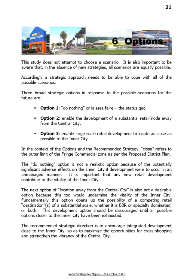
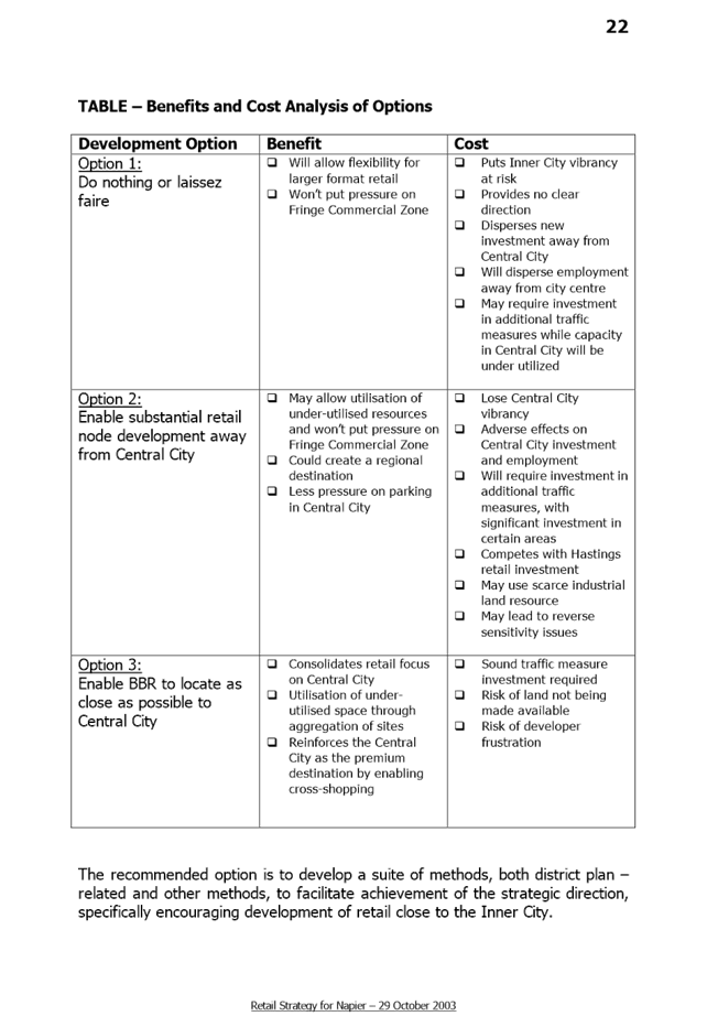
1.6 Options
The
options available to Council are as follows:
1. Review the Retail
Strategy
2. Not to review the
Retail Strategy
1.7 Development of Preferred Option
The preferred option is to review the
Retail Strategy for the reasons outlined above.
1.8 Attachments
a Appendix 1 Retail Strategy ⇩
b Appendix 2 LFR Case Study ⇩
Strategy and
Infrastructure Committee – 31 May 2017 – Open Agenda
Strategy and Infrastructure Committee – 31 May 2017 – Open Agenda
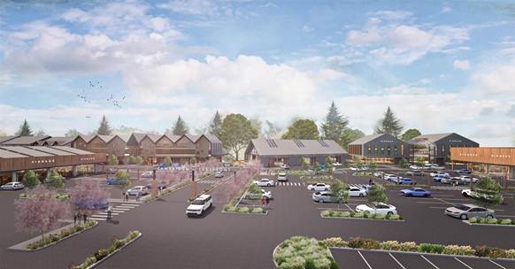
Large Format Retail Case Study
Consideration
as to the position of Large Format Retail (LFR) within a CBD is critical. LFR
sectors reduce the quality of experience, both from an amenity perspective but
also from a City identity view point. By its nature LFR relies on people
driving to the destination by car, thereby reducing the amount of foot traffic
and pedestrian numbers within the city network, and is characterised by
inactive shop frontages and poor urban design principles. These large buildings
are inward facing and surrounded by expansive areas of carpark which add little
to the businesses and properties adjacent.
“Doughnut
Cities” or the “Doughnut Effect” is a recognised phenomenon
encountered around the world. It refers to a city that focusses retail and/or
business outside of the city centre, thereby impacting negatively any activity
at the city core. More and more small cities are experiencing this. A local NZ
example is provided in Hamilton where Large Format Retail (LFR) has been
situated far from the existing town centre, drawing shoppers and activity away
from the heart of the city, and adding limited value to the city’s unique
character and identity.
Hamilton
LFR Precinct
(Inward
facing, extensive central carpark, large oversized buildings)
Napier
is a small (on an international scale) seaside City. It is renowned for its
beautiful Art Deco architecture, its proximity to the coast, and its fantastic
climate. A key ‘point of difference’ for Napier is that we have
managed to retain our compact CBD, and subsequently have a much more vibrant
City Centre than many others of our size. Although some LFR already exists in
Napier, it is appropriately located on the outer fringes of the commercial
area, within easy walking distance of its retail heart. Any future LFR in
Napier would equally need to be appropriately located and designed to ensure
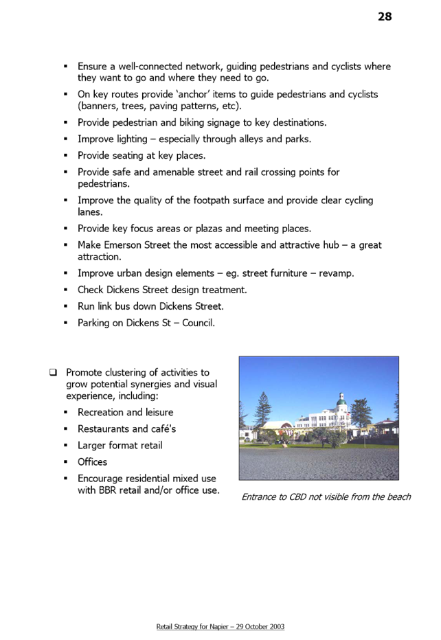
seamless integration with the CBD.


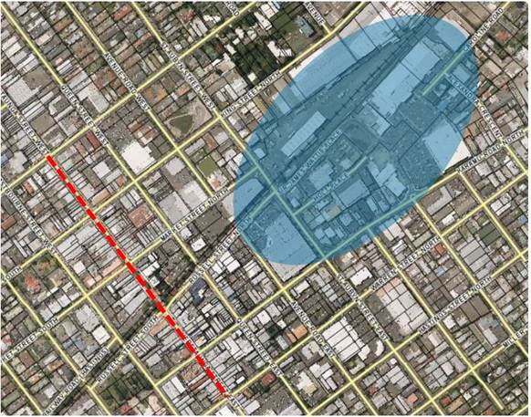
Hastings
CBD and LFR location
Napier’s
close proximity to Hastings’ LFR enables Napier to avoid duplication of
offerings, and supports Napier’s commitment to its vibrant retail heart.
There may be benefit to both cities in Hawkes Bay to adopt a regional approach
to Large Format Retail. Such an approach enables Napier City Council to protect
the City’s existing vibrant city centre while at the same time
strengthening the region’s economic base and increasing prosperity across
the region.
Strategy and Infrastructure Committee – 31 May 2017 – Open Agenda
2. Heritage Improvement Grant
Administration Changes
|
Type of Report:
|
Operational and Procedural
|
|
Legal Reference:
|
N/A
|
|
Document ID:
|
350991
|
|
Reporting Officer/s & Unit:
|
Fleur Lincoln, Strategic Planning Lead
|
2.1 Purpose
of Report
The
purpose of this report is to obtain Council’s approval to redistribute
Napier City Council’s Heritage Improvement Grant to the Art Deco Trust,
so that it may be added to a much larger funding pool available for the
restoration of Napier’s heritage.
|
Officer’s
Recommendation
That
Council:
a. Agree
to disestablish the Napier City Council Heritage Improvement Grant annual
fund of $10,000 per year as of 30 June 2016
b. Approve
that for the 2017/18 financial year, the fund allocation be transferred to
the Art Deco Trust to combine with a larger Robert McGregor Heritage Fund;
and
c. Approve
that an agreement to manage the administration and expectations associated
with this be prepared.
|
|
CHAIRPERSON’S RECOMMENDATION
That the
Council resolve
that the officer’s recommendation be adopted.
|
2.2 Background Summary
Napier
City Council (Council) currently has $10,000 available per year for its
Heritage Improvements Grant. The Grant is available to owners of
Heritage-listed buildings in the Art Deco Quarter, or outside of the CBD but of
commercial nature and a significant example of the Art Deco era style. Details
of this grant can be found in the background of the 2015 report to Council
found in Appendix 1. The changes approved in 2015 introduced the ability for building
owners to claim for scaffolding costs associated with the repainting. The
changes made have had the desired effect of increasing the number of buildings
being repainted, and subsequently, the Grant is now over-subscribed, with a
list of building owners who are waiting for funding to be available to complete
their work. In the future it is hoped that Council’s contribution to this
fund is increased to maintain/refurbish a higher number of buildings in the
future. As a comparison, the Hastings District Council fund for the same
purpose is $22,000/year. In the meantime, Council Officers have been
approached by the Art Deco Trust to make some changes to the way in which this
Grant is administered.
Following
a strategic review by the Art Deco Trust, the Trust has sought to return to the
reason they established – to advocate for and support the retention,
restoration, and enhancement of Napier’s art deco heritage. As such, they
are looking to establish their own heritage fund (the Robert McGregor Heritage Fund),
which may include some private sponsorship from individuals and/or companies,
and other grants received by the Art Deco Trust for this purpose. This fund
would provide for a variety of heritage improvement projects including
repainting, restoration work, maintenance, and repair, and would be paid out to
successful applicants (building owners) on a regular basis as part of funding
rounds. A committee would administer the fund, and would be made up of
representatives of contributory funders and other heritage-related persons.
The
Art Deco Trust approached Council a few months back to ask whether Council
would consider allocating its existing Heritage Improvement Grant of $10,000
per year to this larger fund, administered via the Trust through the committee.
There are both benefits and potential disadvantages associated with this
change.
Napier
City Council and the Art Deco Trust already have a strong working relationship
through the Service Agreement administered by Council’s Community
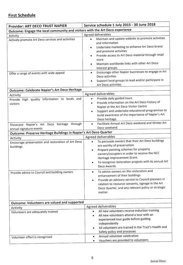
Development department. The Service Schedule outlines those services expected
from the Trust in exchange for this grant, and can be found in Appendix 2.
Although consistent with the expectations outlined in the Service Agreement,
the redistribution of the $10,000/year to the Trust as outlined in this item
will be separate to the former grant, as it will be allocated directly to
private building owners for restoration projects.
Benefits
·
Council’s
contribution would increase the fund available to building owners and create
one large fund available.
·
The larger fund
available means that the scope of the fund can be widened beyond façade
painting.
·
Re-allocating
Council’s fund to the Art Deco Trust would avoid duplication of funds
available in Napier, and the consequent confusion that could ensue if this does
not occur.
·
The close working
relationship between Council and the Art Deco Trust would be further
strengthened, especially in the eye of the public.
·
Council would
continue to have considerable control over the allocation of these funds
through its representative(s) on the committee that assesses applications for
the grant.
Disadvantages
·
The fund would not
be seen as solely a Council initiative.
·
Decisions made on
the allocation of funds would sit with the Committee and not solely with
Council.
The
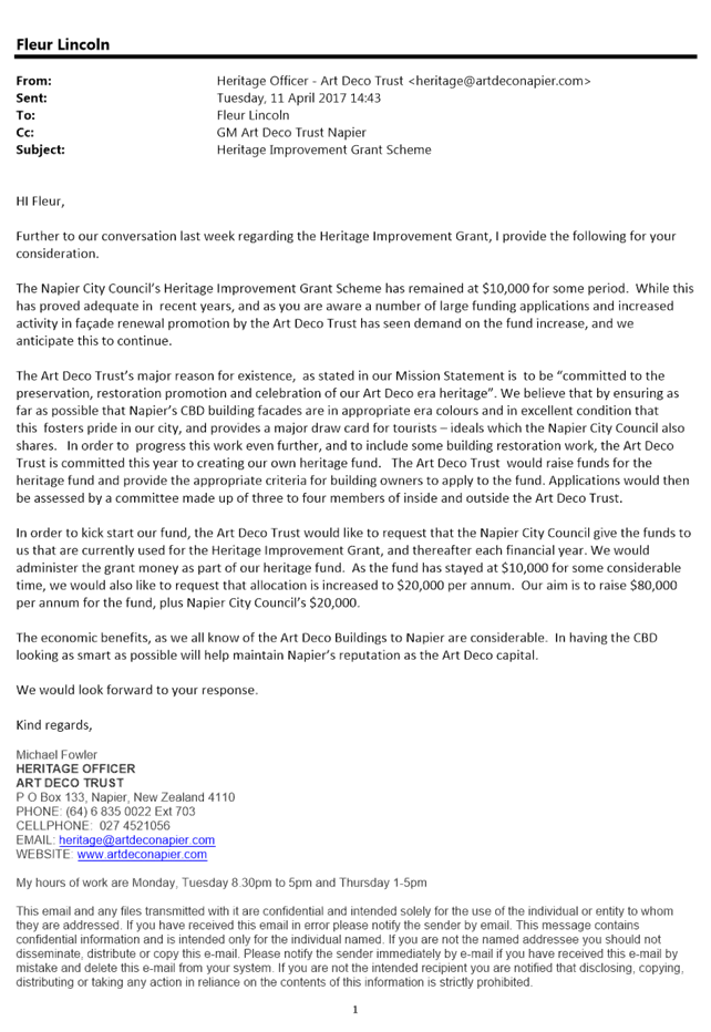
Art Deco Trust have indicated (see attached email in Appendix 1) that they aim
to raise $80,000 per year to contribute to the wider funding pool.
2.3 Issues
The
potential issues have been identified above in 1.2 and include the possibility
that the public no longer sees the fund as being an initiative of Councils, and
that Council loses its sole control over the fund.
2.4 Significance and Consultation
This
item does not meet the criteria established in the Napier City Council
Significance and Engagement Policy.
2.5 Implications
Financial
At
this stage, there is no request to increase the amount of funding for this
grant, however it is likely that a request will be made in the near future to
cover the demand. Any increases would be assessed at that point in time.
If
the Officer’s recommendation is accepted, the $10,000 per year grant will
be disestablished, and the fund allocation transferred to the Art Deco Trust
for administration, subject to meeting a number of conditions. These are yet to
be finalised, but will include requirements such as having at least one
representative from Council on the funding committee; and the requirement to
redistribute 100% of the funds to building owners for heritage building restoration
work. Council’s representative will be significantly involved in the
preparation of the criteria and management of the fund, as well as marketing
and communications.
Social & Policy
It
is believed that no Council Policies are required to be amended as a result of
this change. An agreement will be put in place to manage the redistribution of
the funds and relationship and expectations between Council and the Art Deco
Trust.
Risk
Any
risks to Council are minor and can be easily managed through written agreements
and effective communication.
2.6 Options
The
options available to Council are as follows:
1. Accept
the Officer’s recommendation to disestablish Council’s Heritage
Improvement Grant of $10,000/year and redistribute the funds allocated to the Art
Deco Trust so that it may be used in conjunction with a larger fund for
heritage building restoration (the Robert McGregor Heritage Fund).
2. Reject
the Officer’s recommendation and retain the Heritage Improvement Grant as
it currently is.
2.7 Development of Preferred Option
The
Officer’s preferred option is (1) above. It is believed that the benefits
of this option outweigh the potential costs or risks, as noted in section 1.2
above. In addition, the benefits of a city that protects, celebrates, and supports
its heritage fabric, particularly one as unique as Napier, cannot be
under-estimated. Napier is already a drawcard for thousands of tourists a year,
and this is expected to continue to increase as cheaper flights, more cruise
ship arrivals, and improved transportation links make Napier an attractive
destination. In a world where globalisation has the potential to create
‘sameness’ in our cities, our heritage is what makes us unique. A
larger heritage fund that can support building owners whose costs are generally
higher than owners of more modern buildings, will contribute to the creation of
a more attractive, vibrant, and resilient city.
2.8 Attachments
a 2015 Council Minutes - Changes to Heritage Improvement
Grant ⇩
b NCC_ADT Service Schedule 2015-2017 ⇩
c Email from Art Deco Trust - Request for fund allocation ⇩
Strategy and
Infrastructure Committee – 31 May 2017 – Open Agenda
Strategy and Infrastructure Committee – 31 May 2017 – Open Agenda
Strategy and Infrastructure Committee – 31 May 2017 – Open Agenda
Strategy and Infrastructure Committee – 31 May 2017 – Open Agenda
3. Clifton to Tangoio Coastal Hazards
Strategy 2120 - Progress Update
|
Type of Report:
|
Enter Significance of Report
|
|
Legal Reference:
|
Enter Legal Reference
|
|
Document ID:
|
352640
|
|
Reporting Officer/s & Unit:
|
James Minehan, Development Planner
|
3.1 Purpose
of Report
To
inform and update Council about the progress on the Clifton to Tangoio Coastal
Hazard Strategy since the last report presented to Council in June 2016 and to
obtain approval of funding additional unbudgeted expenditure.
|
Officer’s
Recommendation
That Council:
a. Receives
the Officer’s Report Clifton to Tangoio Coastal Hazards Strategy
2120 – Progress Update.
b. Endorses
the following reports adopted by the Clifton to Tangoio Coastal Hazards
Strategy Joint Committee (28 February 2017):
- Clifton to Tangoio Coastal Hazards
Strategy 2120: Coastal Hazard Assessment,
Tonkin & Taylor, May 2016 (Attachment A).
- Clifton to Tangoio
Coastal Hazards Strategy 2120: Coastal Risk Assessment
Tonkin & Taylor, May 2016 (Attachment B)
- Stage Two Report:
Decision Making Framework, Mitchell Daysh, February
2017, (Attachment C)
c. Endorses
the updated Terms of Reference (Attachment D) adopted by the Clifton to
Tangoio Coastal Hazards Strategy Joint Committee (5 December 2016).
d. Notes
that the forecast project costs have now been incurred and that funding of
$110,000 will be sourced from year end budgets.
|
|
CHAIRPERSON’S
RECOMMENDATION
That the
Council resolve
that the officer’s recommendation be adopted.
|
3.2 Background Summary
The
New Zealand Coastal Policy Statement requires Local Authorities to consider and
plan for coastal hazards risks. Under Policy 24 (1), Local Authorities are
required to “Identify areas in the coastal environment that are
potentially affected by coastal hazards (including tsunami), giving priority to
the identification of areas at high risk of being affected. Hazard risks, over
at least 100 years, are to be assessed…”
Subsequently,
in 2014 a decision was made to form a joint committee made up of
representatives of the Hawke’s Bay Regional Council, Hastings District
Council and Napier City Council together with representatives from
Maungaharuru-Tangitu Trust, Mana Ahuriri Incorporated and He Toa Takitini. The
committee was set-up to look at coastal hazards over the period 2016-2120. The
strategy is to determine options for managing coastal hazard risks, namely
beach erosion, inundation through overtopping and sea level rise and tsunami.
The
Clifton to Tangoio Coastal Hazards Strategy Joint Committee (Joint Committee)
was re-established by resolution of the Hawkes Bay Regional, Hastings District
and Napier City Councils at their respective first meetings following the 2016
local elections. The Technical Advisory Group (TAG) recommended some changes to
the Terms of Reference to the Joint Committee meeting on 5 December 2016. This
was to reflect how the strategy had evolved from the original Terms of
Reference (2014). Subsequently at the Joint Committee meeting on 5 December
2016 it was agreed to present the updated Terms of Reference back to the
partner councils for endorsement.
The
Strategy is being progressed in four key stages as shown in figure 1 below.
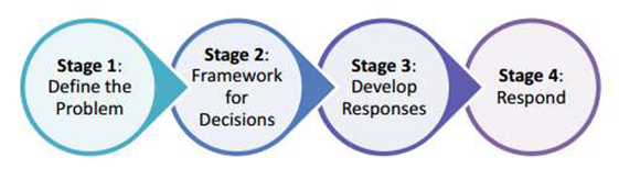
Stage 1
Define the Problem - commenced in 2014 with two reports being prepared –
“Coastal Hazard Assessment” and “Coastal Risk
Assessment”. While the coastal erosion component of the reports was peer
reviewed by Professor Paul Kench of Auckland University in 2016, his review of
the inundation component has just been completed this year.
The
peer reviews have confirmed the adequacy of the scientific reports for the
purposes of the strategy. At its meeting on 28 February 2017 the Joint
Committee received the peer review update and reconfirmed the adoption of both
Stage 1 reports. The Joint Committee subsequently recommended that the peer
reviewed Stage 1 reports be presented back to the Napier City, Hastings
District and Hawke’s Bay Regional Councils for their respective adoption.
Stage 2
Framework for Decisions - began in May 2016 with Environmental Management
Services (EMS) and Maven Consulting Ltd (Maven) working on a “Decision
Making Framework” for community engagement. This provides a framework for
communities to consider different management strategies, i.e. “the status
quo” (do nothing/monitor the situation), “hold the line”
(defend) or “managed retreat” (withdrawing, relocation, or
abandonment) for specific areas along the coast. The decision-making framework
was explained to Councillors at a workshop with the partner councils on 29
August 2016.
Since
then the following activities has been undertaken.
Two
main assessment cell areas have been identified. One is to the south of Napier
Port extending to Clifton. The other one is to the north, including the Napier
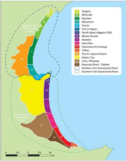
Port, and extending to Tangoio (see the figure below). This recognises that for
coastal processes, a response in one area may well have impacts on another.
These cells themselves represent aggregations of smaller coastal units having
distinct characteristics or risk profiles.
Subsequently
two cell assessment panels (one southern and one northern) have been formed and
are involved in developing and evaluating response options as part of Stage 3
of the project. These panels have community representatives from
Tangoio/Whirinaki, BayView, Westshore/Ahuriri, Marine Parade, Clive/East Clive,
Haumoana/TeAwanga/Clifton. Other participants include a representative from the
port, ahuriri business, NZTA, DOC, recreational interests, and community board
(rural). To date each of these panels has completed five out of ten planned
workshops.
The
panels are supported in their work by staff from the three contributing
Councils and a group of scientists and researchers. The team of scientists and
researchers are from one of the government’s contestable funding
initiatives (the national science challenges) known as “Living on the
Edge”. The Living on the Edge focus is the communities exposed to natural
hazards located on the margins i.e. coastal margins and flood plains.
Under the guidance of programme leader Professor Paul Kench (University of
Auckland) the group has aligned their community case study with that of the
Clifton to Tangoio Coastal Hazards Strategy 2120.
Work
also continues on the establishment of funding guidelines for the potential
protection work, relocation, or retreat options. This will indicate how funding
decisions could be made and specifically how private versus public benefits and
costs are to be apportioned. This work has input from Maven Consultants and
financial staff from the partner councils to assist the panels in their option
assessments. This work is currently ongoing but is expected to be completed by
the conclusion of the cell assessment panel meetings.
The
mechanism for collecting and funding works over longer timeframes linked to
climate change/sea level rise poses new challenges for funding. This highlights
the need for the following:
-Council
collaboration on funding.
-Transparency
in decision-making.
-Addressing
intergenerational responsibilities.
-Funding
frameworks that are able to survive successive political cycles over the longer
timeframe.
Stage 3
Develop Responses - An adaptive pathway model has been utilised to assist the
panels to map out initial response options. It also indicates the
interrelationships between the response options and timelines. This model has
been utilised in the Netherlands (known there as “Dynamic Adaptive Policy
Pathways”). It is a useful model where risk profiles can change over time
and there is uncertainty around rates and magnitudes of change especially over
the long term. Effectively it means that there may be several responses to
coastal hazards over particular stretches of the coast over the next 100 years
(rather than reliance on any single option).
The
Technical Advisory Group (TAG) are currently looking at ways to complement the
adaptive pathway model with other decision-making methods. These include
multi-criteria decision analysis, benefit cost analysis, and real options
analysis. These assessment methods has been used in other projects such as the
Townville City Council Coastal Hazard Pilot Study (2012) and Greater Wellington
Regional Council Hutt River Flood Protection (2015) to assist community lead
decision making.
At
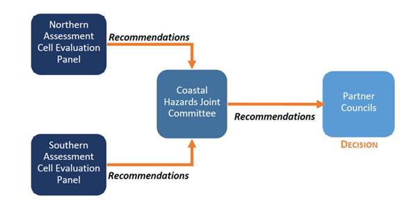
the conclusion of their deliberations, each Cell Assessment Panel will make
final recommendations back to the Joint Committee. Where financial decisions
are required about the expenditure of public funds, the Joint Committee will
refer these to each partner Council. This relationship is shown in the figure
below.
The
assessment panels’ deliberations will be available to the Joint Committee
to make its recommendations back to their respective Councils by the end of
this calendar year. This will allow any anticipated funding to be included in
draft Long Term Plans and 30 Year Infrastructure Strategies for broader
community consultation in the first half of 2018.
3.3 Issues
The
issue is to develop a coastal strategy that will deal with changing climate and
related sea level rise and the subsequent problems with erosion and inundation.
The
New Zealand Coastal Policy Statement requires Local Authorities to consider and
plan for coastal hazards risks. Under Policy 24 (1), Local Authorities are
required to “Identify areas in the coastal environment that are
potentially affected by coastal hazards (including tsunami), giving priority to
the identification of areas at high risk of being affected. Hazard risks, over
at least 100 years, are to be assessed…”
Projected
increases in sea level between 0.3 and 0.6m by 2065 and 0.6m and 1.5m by 2120
have been adopted for the Strategy. These ranges are based on the latest
Intergovernmental Panel on Climate Change (IPCC) estimates for global sea level
rise, together with additional local information and reporting. These projected
figures align with recent reports prepared by the Parliamentary Commissioner for
the Environment. They do not take into account a worst case scenario i.e. rapid
melting of the Antarctic ice shelves.
3.4 Significance and Consultation
Clifton
to Tangoio is the most developed and populated part of the Hawke’s Bay
coastline. As well as hundreds of people’s homes located along this
coast, there are businesses and industry, roads, bridges,
electrical/gas/water/sewage services, a seaport and an airport.
Therefore
the strategy needs to identify areas that could be affected by various coastal
hazards over medium and long term and the risks to public and private property,
cultural sites and areas, recreational use and infrastructure services.
The
long term vision for the Strategy is that “Coastal communities,
businesses and critical infrastructure from Tangoio to Clifton are resilient to
the effects of coastal hazards”.
As
the project has progressed there has been many opportunities for residents,
landowners, businesses, and stakeholders to get involved. The website
www.hbcoast.co.nz has all the information relevant to the project and is
up-dated regularly. On the website the public can find:
-The
latest information and research.
-Public
presentations and meetings.
-Opportunities
for people to learn more and have their say.
There
has been extensive stakeholder engagement over the last year including
community meetings and meetings at marae. As a result of these engagements two
cell assessment panels have now been established with representatives from the
various communities of interest. Under this collaborative model the coastal
hazard strategy will be developed and response options evaluated.
3.5 Implications
Financial
Council
has agreed to contribute a third of the costs of the strategy with Hastings
District Council and the Hawkes Bay Regional Council. Napier City Council
allocated a budget of $50,000 this financial year. The actual cost is now
$160,000 resulting in unbudgeted expenditure of $110,000. This is due to
additional unbudgeted, but critical work, to support the assessment panels that
make recommendations back to the Joint Committee. It is recommended that
funding for the additional cost is sourced through year end budgets.
Costs
occurred to date have paid for:
-Tonkin
and Taylor’s coastal erosion assessment, coastal inundation assessment,
and a risk assessment and a peer review of these assessments by Professor Paul
Kench of Auckland University.
-Initial
work by EMS/Maven Consultancies to develop a strategic framework for
decision-making and developing funding options.
-Erosion
profiles and inundation mapping.
-Communication
strategy including website design and set-up.
-Community
representatives on the assessment panels have made a time commitment. Those not
already in paid employment from representative organisations will receive a
modest monetary acknowledgment per meeting they attend.
It
is anticipated that another $100,000 will be required for the next financial
year to complete the rest of the work to the end of 2017. This has been
included in Council’s 2017/18 Annual Plan.
Social & Policy
The
social and economic costs to the region of not addressing potential coastal
hazards in the medium to long term are high as are the risks to public and
private property, cultural sites, recreational areas and infrastructure
services.
As
a policy issue the initiative provides an opportunity for the community to
address coastal issues in an integrated manner and on a regional scale taking
into account intergenerational equity arguments (who pays and when).
Risk
The
risk assessment undertaken by Tonkin and Taylor indicates the key areas where
infrastructure and communities are under threat. This information is available
on the HB Coast website and is covered by the Tonkin and Taylor report
“Coastal Risk Assessment”. Elements at risk include the safety of
the resident population and the loss of economic, social, cultural and
environmental/ecological assets.
3.6 Options
The
Napier City Council has already made a commitment to this project in terms of
staff and funding and agreed to the original Terms of Reference for the Clifton
to Tangoio Coastal Hazards Strategy Joint Committee.
The
only other option is for Napier City Council to withdraw from the joint
strategy and work independently from the other partner councils. This would not
achieve the purpose of developing an integrated coastal strategy from Clifton
to Tangoio.
3.7 Development of Preferred Option
The
Napier City Council is already committed to this project as mentioned above and
therefore it would be beneficial for all parties for this to continue.
3.8 Attachments
a Coastal Hazard Assessment, Tonkin & Taylor, May 2016
(Under Separate Cover) ⇨
b Coastal Risk Assessment, Tonkin & Taylor, May 2016
(Under Separate Cover) ⇨
c Decision Making Framework, Mitchell Daysh, February 2017
(Under Separate Cover) ⇨
d Updated Terms of Reference, December 2016 ⇩
Strategy and
Infrastructure Committee – 31 May 2017 – Open Agenda
Terms of Reference for
the Clifton to Tangoio Coastal Hazards Strategy Joint Committee
As at 5
December 2016
1. Definitions
For
the purpose of these Terms of Reference:
“Act”
means the Local Government Act 2002.
“Administering
Authority” means Hawke’s Bay Regional Council.
“Coastal
Hazards Strategy” means the Coastal Hazards Strategy for the Hawke
Bay coast between Clifton and Tangoio[1].
“Council
Member” means an elected representative appointed by a Partner
Council.
“Hazards”
means natural hazards with the potential to affect the coast, coastal
communities and infrastructure over the next 100 years, including, but not
limited to, coastal erosion, storm surge, flooding or inundation of land from
the sea, and tsunami; and includes any change in these hazards as a result of
sea level rise.
“Joint
Committee” means the group known as the Clifton to Tangoio Coastal
Hazards Strategy Joint Committee set up to recommend both draft and final
strategies to each Partner Council.
“Member”
in relation to the Joint Committee means each Council Member and each Tangata
Whenua Member.
“Partner
Council” means one of the following local authorities: Hastings
District Council, Napier City Council and Hawke’s Bay Regional Council.
“Tangata
Whenua Appointer” means:
o The
trustees of the Maugaharuru-Tangitu Trust, on behalf of the Maugaharuru-Tangitu
Hapu;
o Mana
Ahuriri Incorporated, on behalf of Mana Ahuriri Hapu;
o He
Toa Takitini, on behalf of the hapu of Heretaunga and Tamatea.
“Tangata
Whenua Member” means a member of the Joint Committee appointed by a
Tangata Whenua Appointer
2. Name and status of Joint
Committee
2.1 The
Joint Committee shall be known as the Clifton to Tangoio Coastal Hazards
Strategy Joint Committee.
2.2 The
Joint Committee is a joint committee under clause 30(1)(b) of Schedule 7 of the
Act.
3. Partner Council Members
3.1 Each
Partner Council shall appoint two Council Members and alternates to the Joint
Committee. If not appointed directly as Council Members, the Mayors of Hastings
District Council and Napier City Council and the Chairperson of Hawke’s
Bay Regional Council are ex officio Council Members.
3.2 Under
clause 30(9) Schedule 7 of the Act, the power to discharge any Council Member
on the Joint Committee and appoint his or her replacement shall be exercisable
only by the Partner Council that appointed the Member.
4. Tangata Whenua Members
4.1 Each
Tangata Whenua Appointer may appoint one member to sit on the Joint Committee.
4.2 Each
Tangata Whenua Appointer must make any appointment and notify all Tangata
Whenua Appointers and Partner Councils in writing of the appointment.
4.3 The
Tangata Whenua Members so appointed shall be entitled to vote.
4.4 Under
clause 30(9) Schedule 7 of the Act, the power to discharge any Tangata Whenua
Member on the Joint Committee and appoint his or her replacement shall be
exercisable only by the Tangata Whenua Appointer that appointed the Member.
5. Purpose of Terms of Reference
5.1 The
purpose of these Terms of Reference is to:
6.1.1 Define
the responsibilities of the Joint Committee as delegated by the Partner
Councils under the Act.
6.1.2 Provide
for the administrative arrangements of the Coastal Hazards Strategy Joint
Committee as detailed in Appendix 2.
6. Meetings
6.1 Members,
or their confirmed alternates, will attend all Joint Committee meetings.
7. Delegated authority
7.1 The
Joint Committee has the responsibility delegated by the Partner Councils for:
Guiding
and providing oversight for the key components of the strategy including:
o The
identification of coastal hazards extents and risks as informed by technical
assessments;
o A
framework for making decisions about how to respond to those risks;
o A
model for determining how those responses shall be funded; and
o A
plan for implementing those responses when confirmed.
Considering
and recommending a draft strategy to each of the Partner Councils for public
notification;
Considering
comments and submissions on the draft strategy and making appropriate
recommendations to the Partner Councils;
Considering
and recommending a final strategy to each of the Partner Councils for approval.
8. Powers not delegated
8.1 The
following powers are not delegated to the Joint Committee:
Any
power that cannot be delegated in accordance with clause 32 Schedule 7 of the
Local Government Act 2002.
The
determination of funding for undertaking investigations, studies and/or
projects to assess options for implementing the Coastal Hazards Strategy.
9. Remuneration
9.1 Each
Partner Council shall be responsible for remunerating its representatives on
the Joint Committee and for the cost of those persons' participation in the
Joint Committee.
9.2 The
Administering Authority shall be responsible for remunerating the Tangata
Whenua Members.
10. Meetings
10.1 The
New Zealand Standard for model standing orders (NZS 9202:2003), or any New
Zealand Standard substituted for that standard, will be used to conduct Joint
Committee meetings as if the Joint Committee were a local authority and the
principal administrative officer of the Hawke’s Bay Regional Council or
his or her nominated representative were its principal administrative officer.
10.2 The
Joint Committee shall hold all meetings at such frequency, times and place(s)
as agreed for the performance of the functions, duties and powers delegated
under this Terms of Reference.
10.3 Notice
of meetings will be given well in advance in writing to all Joint Committee
Members, and not later than one month prior to the meeting.
10.4 The
quorum shall be 5 Members.
11. Voting
11.1 In
accordance with clause 32(4) Schedule 7 of Act, at meetings of the Joint
Committee each Council Member has full authority to vote and make decisions
within the delegations of this Terms of Reference on behalf of the Partner
Council without further recourse to the Partner Council.
11.2 Where
voting is required, all Members of the Joint Committee have full speaking
rights.
11.3 Each
Member has one vote.
11.4 Best
endeavours will be made to achieve decisions on a consensus basis.
11.5 Standing
Orders 2.5.1(2) and 3.14.2 which state: The Chairperson at any meeting has a
deliberative vote and, in the case of equality of votes, also has a casting
vote” do not apply to the Joint Committee.
12. Election of Chairperson and Deputy
Chairperson
12.1 On the
formation of the Joint Committee the members shall elect a Joint Committee
Chairperson and may elect up to two Deputy Chairpersons. The Chairperson is to
be selected from the group of Council Members.
12.2 The
mandate of the appointed Chairperson or Deputy Chairperson ends if that person
through resignation or otherwise ceases to be a member of the Joint Committee.
13. Reporting
13.1 All
reports to the Committee shall be presented via the Technical Advisory Group[2] or from the
Committee Chairperson.
13.2 Following
each meeting of the Joint Committee, the Project Manager shall prepare a
summary report of the business of the meeting and circulate that report, for
information to each Member following each meeting. Such reports will be in
addition to any formal minutes prepared by the Administering Authority which will
be circulated to Joint Committee representatives.
14. Good faith
14.1 In the
event of any circumstances arising that were unforeseen by the Partner
Councils, the Tangata Whenua Appointers, or their respective representatives at
the time of adopting this Terms of Reference, the Partner Councils and the
Tangata Whenua Appointers and their respective representatives hereby record
their intention that they will negotiate in good faith to add to or vary this
Terms of Reference so to resolve the impact of those circumstances in the best
interests of the Partner Councils and the Tangata Whenua Appointers
collectively.
15. Variations to these Terms of Reference
15.1 Any
Member may propose a variation, deletion or addition to the Terms of Reference
by putting the wording of the proposed variation, deletion or addition to a
meeting of the Joint Committee.
15.2 Amendments
to the Terms of Reference may only be made with the approval of all Members.
16. Recommended for Adoption by
16.1 The
Coastal Hazards Strategy Joint Committee made up of the following members
recommends this Terms of Reference for adoption to the three Partner Councils:
Napier
City Council represented
by Cr T Jeffery
Cr L
Dallimore
Refer
to Council paper 2 November 2016
Hastings
District Council represented
by Cr T Kerr
Cr
R Heaps
Refer
to Council paper 8 November 2016
Hawke’s
Bay Regional Council represented
by Cr P Beaven
Cr
P Bailey
Refer
to Council paper 9 November 2016
Maungaharuru-Tangitū
Trust (MTT) represented by Mrs
T Hopmans
Mana
Ahuriri Inc represented
by Mr T Wilson
He
Toa Takitini represented
by Mr P Paku
Appendix 1 – Project Background
Project
Goal
A Clifton to Tangoio Coastal Hazards Strategy is being developed
in co-operation with the Hastings District Council (HDC), the Hawke’s Bay
Regional Council (HBRC), the Napier City Council (NCC), and groups representing
Mana
Whenua and/or Tangata Whenua. This strategy is being
developed to provide a framework for assessing coastal hazards risks and
options for the management of those risks for the next 105 years from 2015 to
2120.
The long term vision for the strategy is that coastal communities,
businesses and critical infrastructure from Tangoio to Clifton are resilient to
the effects of coastal hazards.
Project
Assumptions
The Coastal Hazards Strategy will be based on and influenced by:
The
long term needs of the Hawke’s Bay community
Existing
policies and plans for the management of the coast embedded in regional and
district council plans and strategies.
Predictions
for the impact of climate change
The
National Coastal Policy Statement
Project
Scope
The Coastal Hazards Strategy is primarily a framework for
determining options for the long term management of the coast between Clifton
and Tangoio. This includes:
Taking
into account sea level rise and the increased storminess predicted to occur as
a result of climate change, an assessment of the risks posed by the natural
hazards of coastal erosion, coastal inundation and tsunami.
The
development of a framework to guide decision making processes that will result
in a range of planned responses to these risks
The
development of a funding model to guide the share of costs, and mechanisms to
cover those costs, of the identified responses.
The
development of an implementation plan to direct the implementation of the
identified responses.
Stakeholder
involvement and participation.
Protocols
for expert advice and peer review.
An
action plan of ongoing activity assigned to various Members.
The Strategy will:
Describe
a broad vision for the coast in 2120, and how the Hawke’s Bay community
could respond to a range of possible scenarios which have the potential to
impact the coast by 2120.
Propose
policies to guide any intervention to mitigate the impact of coastal processes
and hazards through the following regulatory and non-regulatory instruments:
o Regional
Policy Statement
o District
Plans
o Council
long-term plans
o Infrastructure
Development Planning (including both policy and social infrastructure
networks).
Strategy and
Infrastructure Committee – 31 May 2017 – Open Agenda
Appendix 2 - Administering Authority and
Servicing
The
administering authority for the Coastal Hazards Strategy Joint Committee is
Hawke’s Bay Regional Council.
The
administrative and related services referred to in clause 16.1 of the
conduct of the joint standing committee under clause 30 Schedule 7 of the Local
Government Act 2002 apply.
Until
otherwise agreed, Hawke’s Bay Regional Council will cover the full
administrative costs of servicing the Coastal Hazards Strategy Joint Committee.
A
technical advisory group (TAG) will service the Coastal Hazards Strategy Joint
Committee.
The
TAG will provide for the management of the project mainly through a Project Manager.
TAG will be chaired by the Project Manager, and will comprise senior staff
representatives from each of the participating Councils and other parties as
TAG deems appropriate from time to time. TAG will rely significantly on input
from coastal consultants and experts.
The
Project Manager and appropriate members of the TAG shall work with
stakeholders. Stakeholders may also present to or discuss issues directly
with the Joint Committee.
Functions of the TAG include:
o Providing technical
oversight for the study.
o Coordinating agency
inputs particularly in the context of the forward work programmes of the
respective councils.
o Ensuring council
inputs are integrated.
Strategy and Infrastructure Committee – 31 May 2017 – Open Agenda
4. Land legalisation - 2 Hastings Street
& 12 Browning Street, Napier
|
Type of Report:
|
Legal
|
|
Legal Reference:
|
Public Works Act 1981
|
|
Document ID:
|
352620
|
|
Reporting Officer/s & Unit:
|
Bryan Faulknor, Manager Property
Jenny Martin, Property and Facilities Officer
|
4.1 Purpose
of Report
To
obtain Council approval, pursuant to Section 114 of the Public Works Act 1981
to declare the land in the Schedule to be road.
|
Officer’s
Recommendation
That Council
a. Consents,
in accordance with Section 114 of the Public Works Act 1981, to the
land described in the Schedule hereto to be declared road and vested in the
Napier City Council.
SCHEDULE
Hawke’s
Bay Land District – Napier City
|
Area (ha)
|
Legal Description
|
Certificate of Title
|
|
0.0001
|
Lot 8 DP 6356
|
HB 56/57
|
|
0.0002
|
Lot 9 DP 6356
|
HB 56/59
|
|
|
CHAIRPERSON’S
RECOMMENDATION
That the
Council resolve
that the officer’s recommendation be adopted.
|
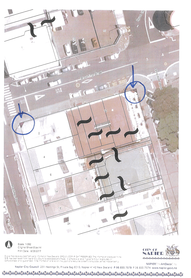
4.2 Background Summary
In
1935, DP 6356 showed as Lots 8 and 9 corner splays on the intersections of
Hershall Street and Hastings Street with Browning Street. Both Lots 8 and 9 and
the adjoining Lot 6 were at the time owned by the Crown for education purposes.
Lot 6 subsequently passed into private ownership but Lots 8 and 9 have remained
in the name of Her Majesty the Queen. The areas are shown on the attached
aerial map highlighted in purple (see Attachment A).
It
is apparent that the parties had intended Lots 8 and 9 to become road but
legalisation was never completed. This has come to light due to proposed road
works in the area.
The
consent of the Crown (as owner of Lots 8 and 9) has been obtained to declare
each lot to be road. Land Information New Zealand have confirmed that Council
does not need the consent of any other parties.
A
declaration by Council declaring the land to be road is now required.
4.3 Issues
There
are no issues.
4.4 Significance and Consultation
Council
lawyers have consulted and obtained consent from the Crown. LINZ have also been
consulted.
4.5 Implications
Financial
Not
applicable.
Social & Policy
Not
applicable.
Risk
Not
applicable.
4.6 Options
The
options available to Council are as follows:
1. To
declare, pursuant to Section 114 of the Public Works Act 1981 the land in the
Schedule to be road.
2. To
not declare the land to be road. This may result in the proposed road works in the area not
going ahead.
4.7 Development of Preferred Option
It
is now appropriate to correct the historic oversight and proceed with the
required declaration.
Not
applicable.
4.8 Attachments
a Lot 8 and Lot 9 DP 6356 ⇩
 NAPIER
CITY COUNCIL
NAPIER
CITY COUNCIL
Civic Building
231 Hastings Street,
Napier
Phone: (06) 835
7579
www.napier.govt.nz
Strategy
and Infrastructure Committee
Open
MINUTES
|
Meeting Date:
|
Wednesday 19 April
2017
|
|
Time:
|
3pm-3.16pm
|
|
Venue:
|
Main Committee Room
3rd floor Civic Building
231 Hastings Street
Napier
|
|
Present:
|
Councillor Price (In the Chair), the
Mayor, Councillors Boag, Brosnan, Dallimore, Hague, Jeffery, McGrath, Tapine,
White, and Wise
|
|
In Attendance:
|
Director Infrastructure Services,
Director Community Services, Manager Communications, Manager City Development
|
|
Administration:
|
Governance Team
|
Strategy and
Infrastructure Committee – 31 May 2017 – Open Agenda
Apologies
CONFLICTS OF
INTEREST
Nil
Public forum
Announcements by
the Mayor
Nil
Announcements by
the Chairperson
Nil
Announcements by
the Management
Nil
Confirmation of
Minutes
|
Councillors Wise / Brosnan
That the Minutes of the meeting held
on 8 March 2017 were taken as a true and accurate record of the meeting.
CARRIED
|
1. Park Island Master Plan Review
|
Type of Report:
|
Legal and Operational
|
|
Legal Reference:
|
Resource Management Act 1991
|
|
Document ID:
|
347334
|
|
Reporting Officer/s & Unit:
|
Antoinette Campbell, Director Community Services
|
1.1 Purpose
of Report
To outline the process undertaken in
reviewing the 2013 Park Island Master Plan and provide the updated Park Island
Master Plan 2016 for Council’s consideration.
|
At the Meeting
Councillors remarked that this plan reflected the
strategic direction of the Council well.
|
|
Committee's
Recommendation
Councillor Brosnan /
Councillor Hague
That Council
a. Adopt the
Park Island Master Plan 2016 and
b. That
a District Plan Change is
initiated to rezone Park Island’s Northern Sports Hub to meet the
Master Plan objectives.
CARRIED
|
2. McLean Park Re-turf Project
|
Type of Report:
|
Operational and Procedural
|
|
Legal Reference:
|
Enter Legal Reference
|
|
Document ID:
|
348170
|
|
Reporting Officer/s & Unit:
|
Debra Stewart, Team Leader Parks, Reserves, Sportsgrounds
|
2.1 Purpose
of Report
The
purpose of this report is to update Council on the Mclean Park Re-turf Project
and seek approval for an additional $330,000 to be transferred from the
Sportsground Renewal fund to enable the hybrid turf to be secured this
(2016/17) financial year.
|
At the Meeting
It was noted that it is necessary to have hybrid turf to
future-proof the park for growth in cricket and other sports.
In response to questions on the preferred option of the
turf, and risks around timing of installation, the Director Infrastructure
Services and Chief Executive advised:
·
there will be
never be a perfect time to install the turf. There will always be a
risk due to the cross-over between the rugby and cricket seasons. Officials
have looked at what events could be set aside during the construction
period. If they delayed the construction any further then council would
lose two 1 day international cricket matches which could result in a three
year wait to secure international cricket matches.
·
the preferred turf
has been around for a number of years and has been tested in a variety of
venues in New Zealand and Australia. The other option for turf had not
been tested to international game standard, only community games.
Therefore, officials selected the turf which has been tried and tested.
·
the preferred turf
is also versatile and can be upgraded if required in future years.
Director Infrastructure Services advised that the drop-in
wicket will be ready for the under-19s world cup which will be held in
January 2018. It was hoped it would be ready by now, but due to
unforeseen events it had to be delayed.
|
|
Committee's
Recommendation
Councillors Jeffery /
Wise
That Council:
a. receive
the report titled McLean Park Re-Turf Project.
b. approve
an additional $330,000 to be transferred to the McLean Park Re-turf Project
from the Sportsground Renewal fund to be spent in the 2016/2017 financial
year.
CARRIED
|
3. Ground lease - Hawke's Bay Speedway Club
Incorporated
|
Type of Report:
|
Legal
|
|
Legal Reference:
|
Reserves
Act 1977
|
|
Document ID:
|
347418
|
|
Reporting Officer/s & Unit:
|
Bryan Faulknor, Manager Property
|
3.1 Purpose
of Report
To
obtain Council approval to grant a new ground lease to the Hawke’s Bay
Speedway Club Incorporated for the land occupied by the Club’s racetrack
and buildings at Papakura Domain for a term of ten years with one ten year
right of renewal.
|
At the Meeting
A discussion occurred on the following points:
·
it was a shame the
set-up for the burnout competition was not right.
·
the lease term at
10 plus 10 appears longer than standard commercial leases.
·
Councillors raised
questions on the conditions of the lease including:
o whether there is a risk of having a
lease that is so long and would Council wish to use that land for other
purposes?
o why is council only provided with this
decision after the lease has expired?
o regarding the change to the sub-lease,
is there any risk with the burn-out company seeking compensation because they
will not be able to use the facility?
·
in response to the
questions raised, the Director Infrastructure Services and Chief Executive
advised
o the long length of the lease is
required to encourage investment into the facilities so that organisations
develop and maintain buildings on council land.
o that it is not uncommon for rights of
renewal to be in place for these sorts of activities and this acts as a
placeholder while the decision is put to Council. In addition, the
negotiations for renewing a lease can take months.
o the sub-lease was with the speedway
club so no obligation of Council to the sub-leasee.
|
|
Committee's
Recommendation
Councillor Brosnan /
Councillor McGrath
That Council
a. Grant
a new ground lease to the Hawke’s Bay Speedway Club Incorporated for
the land occupied by the Club’s racetrack and buildings at Papakura
Domain for a term of ten years with one ten year right of renewal; and
b. That
the terms and conditions of the lease will be as per Council’s standard
terms for leases on Reserve land to community groups.
CARRIED
|
4. Ground lease - hawke's bay seafarers
welfare society incorporated
|
Type of Report:
|
Legal
|
|
Legal Reference:
|
Reserves Act 1977
|
|
Document ID:
|
347419
|
|
Reporting Officer/s & Unit:
|
Bryan Faulknor, Manager Property
|
4.1 Purpose
of Report
To
obtain Council approval to grant a new ground lease to the Hawke’s Bay
Seafarers Welfare Society Incorporated, for the land occupied by the Seafarers
Centre on Marine Parade, for a term of 15 years with one fifteen year right of
renewal.
|
At the Meeting
Questions raised by Councillors included:
·
has there been any
other identification for the use of the land?
·
How much do they
pay for it, and does the price go up when Council is renewing the lease?
·
By the time the
lease comes up they are expired by the time they come to Council for
decision. Would it not be better before the lease runs out for Council
to make a decision on it.
In response to the questions raised, Director
Infrastructure Services and the Chief Executive noted:
·
no one has
expressed interest in the use of the land other than the leasee.
·
It takes time to
negotiate new terms with the lease holder, sometimes months, and this is why
there is the ability in the lease to go straight into a month by month
rolling lease after it expires.
|
|
Action required: Director Infrastructure Services to
report back on how much the lease is and whether they price will go up when
Council is renewing the lease.
|
|
Committee's
Recommendation
Councillor Brosnan /
Councillor Wise
That
Council
a. Grant
a new ground lease to the Hawke’s Bay Seafarers Society Incorporated,
for the land occupied by the Seafarers Centre on Marine Parade, for a term of
15 years with one 15 year right of renewal; and
b. That
the terms and conditions of the lease will be as per Council’s standard
terms for leases on Reserve land to community groups.
CARRIED
|
5. Omarunui Refuse Landfill Joint Committee
Minutes, 17 March 2017
|
Type of Report:
|
Information
|
|
Legal Reference:
|
Local Government Act 2002
|
|
Document ID:
|
347158
|
|
Reporting Officer/s & Unit:
|
Jon Kingsford, Director Infrastructure Services
|
5.1 Purpose
of Report
To
provide key points of interest and a copy of the minutes from the Omarunui
Refuse Landfill Joint Committee meeting held on 17 March 2017.
The meeting ended at 3.16pm.