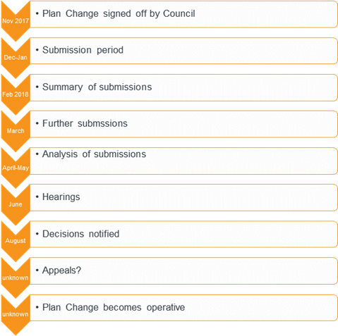
|
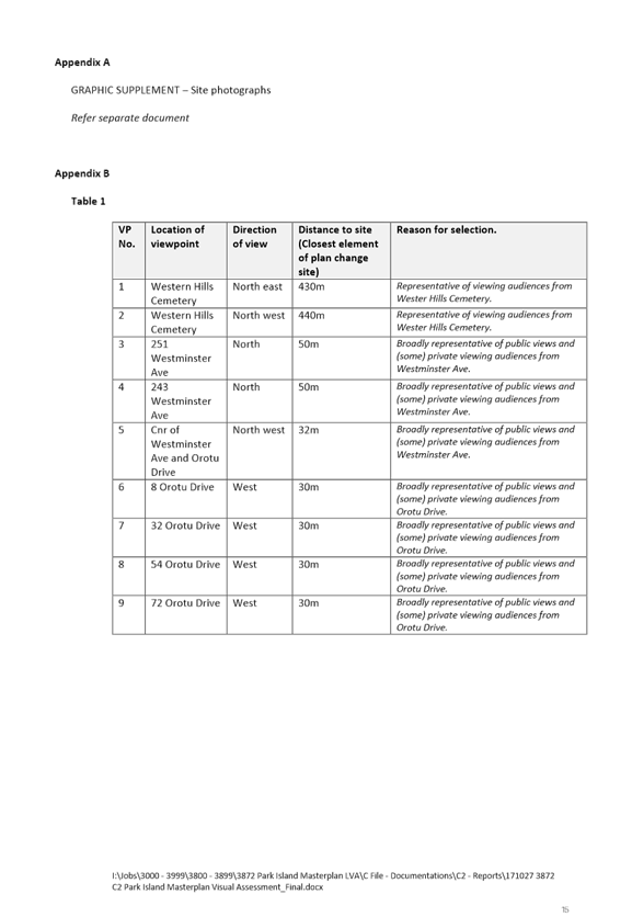
Regulatory Committee - 22 November 2017 - Attachments
|
Item
1
Attachments
a
|
1. INTRODUCTION
The purpose of
this report is to satisfy the requirements of Section 32 of the Resource
Management Act 1991 (RMA) in proposing and notifying Plan Change 11 (PC11) to
the City of Napier District Plan (the Plan).
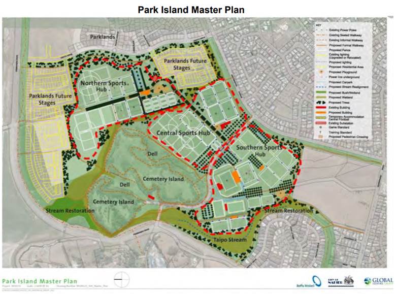
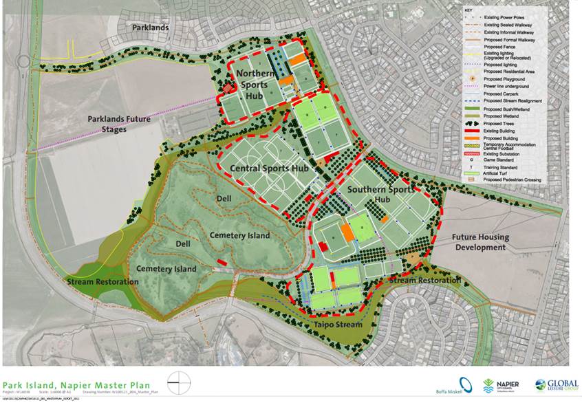
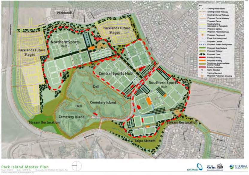
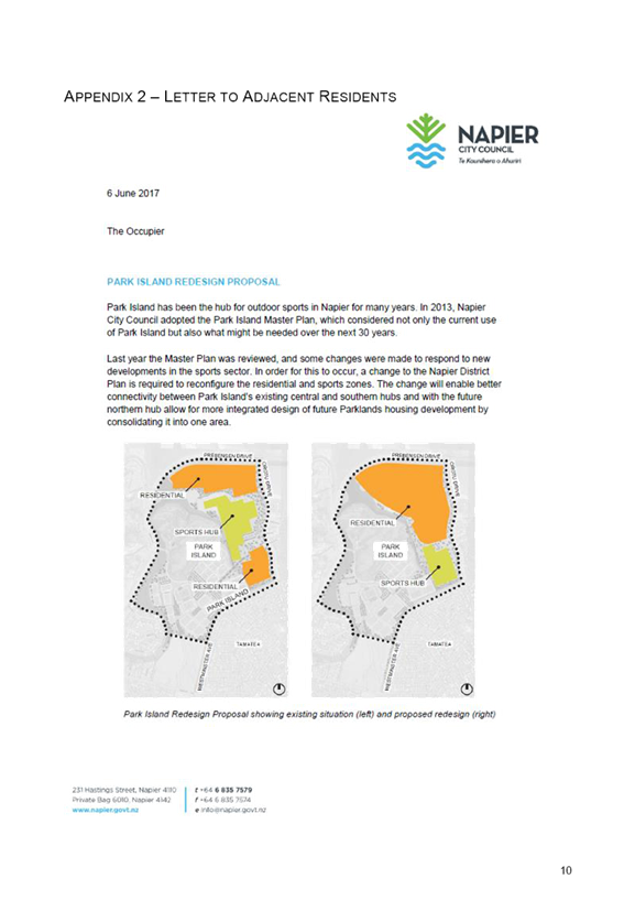
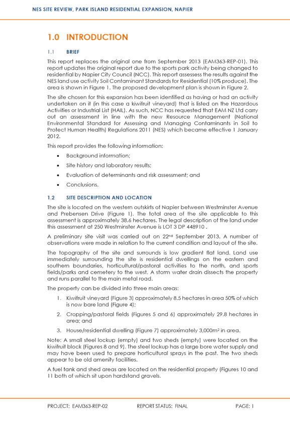
The purpose of
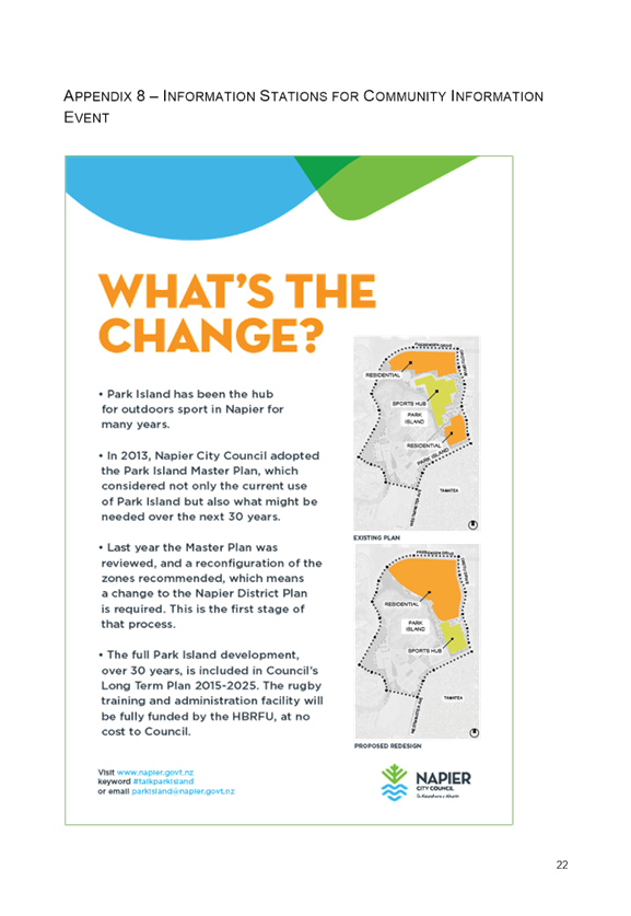
PC11 is to give effect to the recently adopted May 2017 Park Island Master
Plan, which seeks to reconfigure the size and location of the Northern Sport
Hub alongside Oruto Drive. The original 2013 Master Plan and proposed
2017 Master Plan are provided in Appendix 1, with the full 2017 Master Plan
document provided in Appendix 2.
Council’s
review of the current (2013) Master Plan and associated configuration came
about in response to changes in user demands as well as questions around other
matters such as appropriate turf material, layout, connectivity, and
anticipated demands over the next 30 years for delivering and managing
recreational facilities throughout the City.
As an outcome of
this review the physical area of the Northern Sports Hub is proposed to be
reduced and moved southward to allow better connectivity between Park
Island’s Southern and Central Sport Hub. Consequently, the two
residential areas at each end will be merged to form one consolidated area as
conceptually shown in Figure 1 below, with a reserve running west-east through
the centre. The current and proposed Planning Maps are provided in Appendix 3.
With the Northern
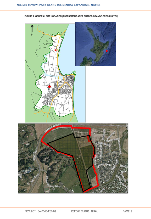
Sports Hub located within the Sports Park Zone of the Plan and the residential
areas at either end within the Main Residential Zone, the Plan Change process
is required to consider and decide upon this reconfiguration of Zones and
associated matters.
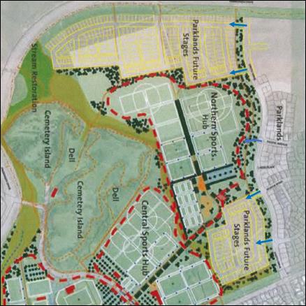
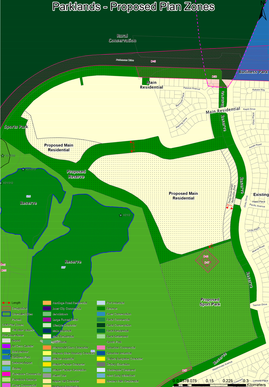
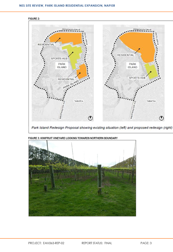
Figure 1: Conceptual Reconfiguration
Existing 2013 Masterplan
Proposed 2017 Masterplan
A number of minor consequential changes
are also proposed. These include:
(1) Rezoning areas of the
Sports Park Zone to a Reserve Zone that already act as reserves, such as the
area of land between Prebsensen Drive and existing Main Residential Zone,
(2) Rezoning areas of the
Main Residential Zone to Reserve Zone that are now reserves, such as the area
in the south east corner of the existing Main Residential Zone alongside Orotu
Drive,
(3) Rezoning areas of the
subject site to better provide for anticipated road linkages as follows:
Rezoning
the existing link opposite Kapiti Drive from Reserve to Main Residential,
Rezoning
the existing link opposite Pacific Drive from Reserve to Main Residential,
(4) Rezoning areas of the
drainage reserve along Orotu Drive from Main Residential to Reserve now that
these areas are no longer required for roading.
Figure 2: Minor Changes


2. Plan change requiRements
The process for preparing, changing or reviewing a Policy
Statement or Plan is provided for in Schedule 1 of the RMA, a key component of
which is the preparation of the Section 32 evaluation Report as required under
Clause 5(1) of Schedule 1.
Section 32 provides
the vehicle for new proposals
to be examined for their appropriateness in achieving the purpose of the RMA
and requires:
the benefits, costs, and risks of
new policies and rules on the community, the economy and the environment to be
clearly identified and assessed,
advice received from iwi
authorities and the response to the advice to be summarised,
analysis of the proposal to be
documented so that stakeholders and decision-makers can understand the
rationale for policy choices.
An evaluation report is
required to examine both:
• the extent to which the
objectives of the proposal (or the purpose of the proposal) are/is the most
appropriate way to achieve the purpose of the RMA (s32(1)(a)); and
• whether the provisions in the
proposal are the most appropriate way in which to achieve the objectives ((or
the purpose of the proposal) by identifying other reasonably practicable
options for achieving the objectives (or purpose); assessing the efficiency and
effectiveness of the provisions in achieving the objectives (purpose); and
summarizing the reasons for deciding on the provisions (s32(1)(b)).
The evaluation
report must contain a level of detail that corresponds to the scale and
significance of the environmental, economic, social, and cultural effects that
are anticipated from the implementation of the proposal (s32(1)(c)).
In considering
the efficiency and effectiveness of the provisions in achieving the objectives
(or purpose) the:
benefits
and costs of the environmental, economic, social, and cultural effects that are
anticipated from the implementation of the provisions, including opportunities
for economic growth and employment that are anticipated to be provided or
reduced (s32(2)(a)) must be identified and assessed, and, if practicable,
quantified s32(2)(b)).
risk of
acting or not acting if there is uncertain or insufficient information about
the subject matter of the provisions must also be assessed (s32(2)(c)).
In this case, PC11 does not, of itself,
contain or state ‘objectives’.
Indeed, the existing objectives pertaining to Residential Environments and the
Sports Park Zone as contained in Chapters 4-13 and 48 of the District Plan
respectively are proposed be retained/adopted. Therefore, pursuant to Section
32(6), ‘objectives’ in this setting relate to ‘the purpose of
the proposal’, which is to:
‘Reconfigure
the Sports Park and Main Residential Zones alongside Oruto Drive’
Similarly, the
‘provisions’ to be evaluated are essentially:
The Policies of the Sports Park
and Main Residential Zones, as currently contained in the District Plan, that
will ‘fall down’ over these areas of the City,
and,
The Rules and
Conditions, Standards and Terms of the Sports Park and Main Residential Zones, as
currently contained in the Activity and Condition Tables of each Zone that will
apply over these areas of the City - together with any new Rules and
Conditions, Standards and Terms that may be proposed.
The first part of the
evaluation therefore has to address:
‘Whether
reconfiguring the Sports Park and Main Residential Zones alongside Oruto Drive
is the most appropriate way to achieve
the purpose of the RMA’.
Included in this
is a reduction in the area of the Sports Park Zone and subsequent increase in
the area of the Main Residential Zone. The evaluation must therefore address
matters associated with both recreation and urban growth.
This higher-level evaluation in
terms of achieving the purpose of the RMA is undertaken in Section 5 where the following is
outlined and considered:
Councils
statutory role in managing sports grounds and urban growth,
Why the
Park Island Master Plan was reviewed?
What was considered
in arriving upon the proposed reconfiguration?
Will
there be sufficient sports ground?
Does the
Plan Change give effect to the Regional Policy Statement?
Secondly, it is a matter of
evaluating the provisions of the proposal in terms of efficiency and
effectiveness. As the starting points are the existing provisions of the two
Zones, the evaluation has to address:
‘Are any
amendments to the existing Policies, Structure Plan, Rules and Conditions of
the existing Zones needed to achieve the reconfiguration and to ensure that any
environmental effects are appropriately avoided, remedied or mitigated.’
This more focused evaluation of
the provisions themselves is undertaken in Section 6 where key issues are
identified and the following matters in particular are considered:
Whether
the Main Residential Zone includes sufficient provision to manage the effects
of the reconfiguration, particularly along the interfaces where there will be a
change in Zone,
The
appropriateness of the existing Rules of the Sports Park Zone to deliver the
intentions of the Park Island Master Plan and Condition 48.12 in particular,
which limits the floorspace of buildings,
The
effectiveness of Condition 48.13 of the Sports Park Zone to manage the effects
of noise on the residential environment along Westminster Avenue and Orotu
Drive that will adjoin the proposed Sports Park Zone,
The
effectiveness of Condition 48.14 of the Sports Park Zone to provide for Sport
Park purposes while also managing the effects of light spill along Westminster
Avenue and Orotu Drive that will adjoin the proposed Sports Park Zone,
Prior to these
assessments however, Section 3 provides an outline of the existing framework of
the District Plan and the nature and form of development that is currently
provided for along the west side of Orotu Drive, followed in Section 4 by an
outline of consultation undertaken with the community and key stakeholders as
part of developing this proposed Plan Change.
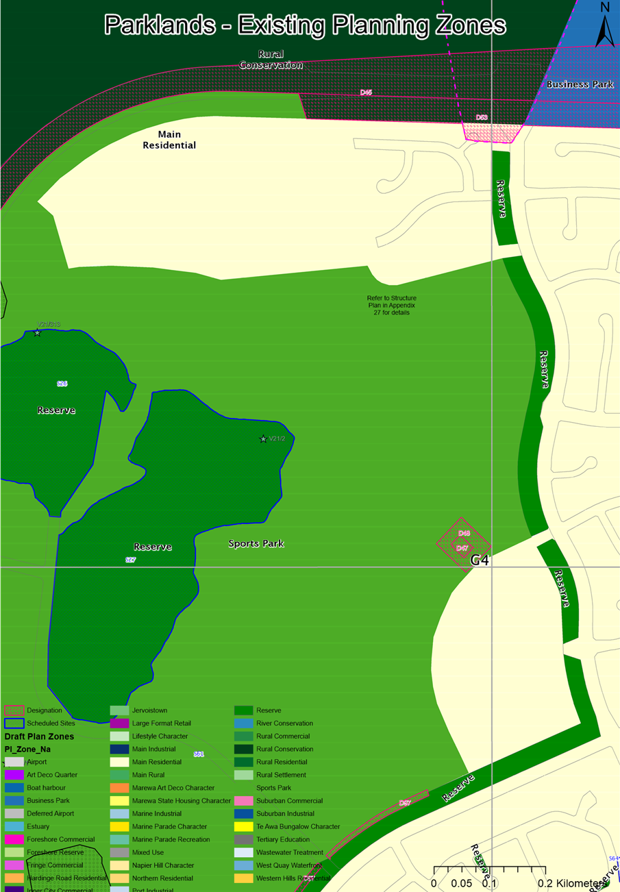
3. EXISTING District plan framework
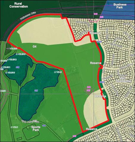
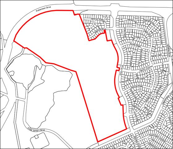
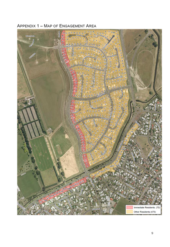
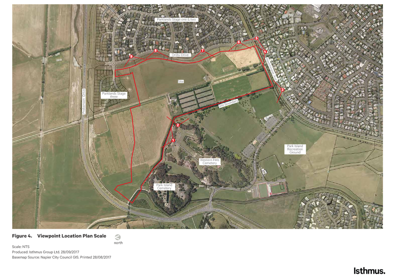
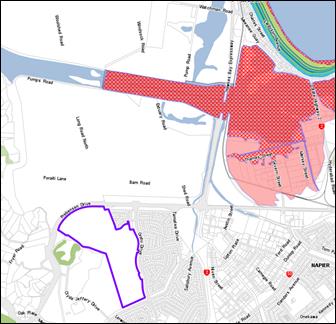
The land subject
to this Plan Change is shown in Figure 3 below. It is characterised by various Zones and Designations, and is
included within the Park Island Structure Plan and Park Island Master Plan
documents contained in Appendices 27 and 34 of the District Plan.
Although the
“site” containing the Northern Sports hub and residential zones
(subject to this Plan Change) is not a ‘Reserve’ in itself, much of
the surrounding land is classified as either Recreation or Drainage Reserve.
Figure 3: Subject Site
Designations
Designations D47 and D48 are for
Electricity Distribution Purposes, with the Requiring Authority being Unison
Networks Limited. The easements running north-south and west-east from these
Designations are in favour of Unison Networks Limited to convey electricity,
telecommunications and electronic data.
Residential Areas
The configuration
of the Main Residential Zone to the north and south, with the Sports Park Zone
in the centre, is the product of the Park Island Master Plan that was developed
in 2013, and which is provided in Appendix 34 of the District Plan (and
Appendix 1 of this report).
The northern
residential area is now consented and being progressively developed in stages
and is therefore not subject to this Plan Change process. This is expanded
on below. Lot layout within the southern residential area has not been
confirmed via the subdivision process so is indicative only.
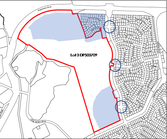
Access to the northern area of the Main Residential Zone was to be
via two new roads, one approximately 60m north of the existing Orotu
Drive/Kapiti Drive roundabout and one approximately 70m south. Access to the
southern area was to be via the Orotu Drive/Akaroa intersection and the Orotu
Drive/Tasman Drive roundabout. Access to the Sports Park Zone was via the Orotu
Drive/Pacific Avenue roundabout. These access points are identified in Figure
4.
Figure 4: 2013 Master Plan Access Points
Activities within the Main Residential Zone
are subject to the provisions contained in Chapter 5 of the District Plan.
Residential activities are provided for as a Permitted Activity under Rule 5.2
subject to compliance with a range of conditions. Here Condition 5.38 states
that “the relevant provisions of any Structure Plan must be complied
with” (namely Appendix 27 which prescribes the key infrastructure
necessary to enable development to proceed).
Northern Residential Area - Subdivision
Consent RMS15019
Subdivision Consent RMS15019 was approved
on 8 January 2016 allowing the creation of 219 residential lots across the full
extent of the northern pocket of the Main Residential Zone. Residential
development within these lots is regulated by the Conditions of the Condition
Table in Chapter 5 of the District Plan, such as an 8m height limit.
Access to this area is
different to that anticipated on the existing Master Plan, in that it is
accessed via the existing Orotu Drive/Kapiti Drive
roundabout via Aspiring Drive rather than new roads on either side. This was to
utilise the existing roundabout control and avoid ‘puncturing’ the
Reserve along the western side of Orotu Drive with an additional road.
A similar
approach has been taken along the southern extents of Orotu Drive where the
configuration of the Reserves has been developed to provide access to the
Sports Park Zone via the Orotu Drive/Pacific Avenue roundabout, and to the
southern pocket of the Main Residential Zone via the Orotu Drive/Tasman Drive roundabout.
This was undertaken for the same reasons as outlined above and is shown in
Figure 5 below, where Lot 3 DP503709 extends between the Reserves to adjoin the
Orotu Drive Road Reserve and where conversely the existing Road Reserve
opposite Tasman Drive extends through the Reserves to adjoin Lot 3 DP503709.
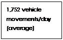
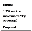
In terms of
traffic generation, the Code of Practice for Subdivision and Land Development
assumes an average 8 vehicle movements per dwelling per day. Based on a total
of 219 lots, an average of 1,752 vehicle movements could be expected at the
western arm of the Orotu Drive/Kapiti Drive roundabout.
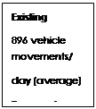
Although a
subdivision proposal has not been confirmed for the southern pocket, based on
an average yield of 15 lots or dwellings per hectare pursuant to POL UD8(a) of
the RPS, approximately 112 lots could reasonably be expected from this area.
Based on an average of 8 vehicle movements per dwelling per day again, an
average of 896 vehicle movements could be expected at the western arm of the
Orotu Drive/Tasman Drive roundabout.
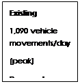
In terms of the
sport hub in the middle, Robin Malley (Team Leader Transportation, Napier City Council) has advised that 1,090 vehicle
movements could be expected during peak days at the western arm of the Orotu
Drive/Pacific Avenue roundabout.
These existing
vehicle movement figures are also illustrated in Figure 5 below.
Figure 5: Access Points and Anticipated
Vehicle Movements West of Orotu Drive


Covenants
In addition to the Rules and Conditions of
the District Plan for the Main Residential Zone, there are also covenants that
have been imposed by the developer that development upon each site must be
undertaken in accordance with. A similar approach had been adopted by the
developer on land east of Orotu Drive, although it is understood that the
covenants have varied slightly over time.
Covenants sit outside the District Plan.
They are not tools to provide for, or manage, urban outcomes in terms of the
achieving the purpose of the RMA, rather they are specific tools determined by
a developer to achieve a certain vision or housing typology that they seek to
achieve/deliver to the market.
The District Plan development process does
not anticipate, nor rely on covenants to achieve the purpose of the RMA. This
is the role of the District Plan itself, and any covenants that a developer
may, or may not, choose to impose at the time of a future subdivision within a
Zone created via a Plan Change is not a Plan Change matter. It is also noted
that there is no obligation for a developer to impose covenants, and under
these situations development may occur within the full ambit of the Conditions
for Permitted Activities within the Zone.
Sports Park Zone
Activities within the Sports Park Zone are subject to
the provisions contained in Chapter 48 of the District Plan. The
following are classified as Permitted Activities under Rule 48.2 subject to
compliance with a range of conditions:
(a) Maintenance
repair of buildings and structures,
(b) Recreational
Activities,
(c) Vehicle
parking areas,
(d) Activities
identified in an approved Management Plan under the Reserves Act 1997,
(e) Activities
identified on the Park Island Master Plan in Appendix 34 including commercial
offices and commercial activities ancillary to sports activities undertaken on
the Park.
Condition 48.12 limits the
maximum floorspace of buildings identified on the Park Island Master Plan to
1,000m2 gross floor area, and any other building on a site not
covered by the Master Plan for Park Island to 500m2 gross floor
area.
Licensed premises in particular are
classified as a Discretionary Activity under Rule 48.7.
Summary
The existing environment is
therefore one that is planned to accommodate both residential and sport park
development, all accessed off Oruto Drive. Although much of this development
has not yet commenced, it is provided for in the District Plan and is anticipated
to establish over time.
4. Consultation
It is stated in Clause 3(1)
that the local authority shall consult with the following parties during the
preparation of a proposed Plan:
(a) the Minister
for the Environment; and
(b) those other Ministers of the Crown who may be
affected by the policy statement or plan; and
(c) local authorities who may be so affected; and
(d) the tangata whenua of the area who may be so
affected, through iwi authorities; and
(e) any customary marine title group in the area.
In terms of the
Minister for the Environment as referred to in (a), a draft of the Section 32
Evaluation Report was provided for comment. No response was received. Regarding
(b), the proposed Plan Change is not considered to raise any specific matters
that would render specific Ministers of the Crown affected.
Turning to (c),
consultation has been undertaken with the Hawkes Bay Regional Council, and with
Mana Ahuriri in terms of (d). This is expanded upon in Sections 4.1 and 4.2 below.
There are no Customary Marine Title Groups in the area concerned by the Plan
Change in terms of (e).
Clause 3(2) goes
onto to state that the local authority may consult
anyone else during the preparation of a proposed Plan. No specific parties in
addition to those outlined in Clause 3(1) are referred to however.
Consultation in
addition to the Clause 3(1) requirements has involved two main streams of work,
(1), consultation with key stakeholder groups in reviewing the Park Island
Master Plan from a sports demand perspective, and (2), consultation with
Tamatea and Parklands residents on matters associated with the proposed
reconfiguration This is expanded upon in Sections 4.3 and 4.4 below. Acting for
Unison, opportunity was also provided to Opus International Consultants Limited
to review the draft Plan Change prior to notification. Opus confirmed that the Proposed Plan Change is unlikely to
have an impact on Unison interests, being Designations D47 and D48.
4.1 Consultation with the Hawkes Bay Regional
Council
A meeting was
held with the Hawkes Bay Regional Council to introduce the project, explain the
reasons for the proposal and to provide an overview of the matters being
considered as part of the Plan Change process.
A draft of the
Section 32 Evaluation Report was provided for comment. Owing to project milestones
the timeframe for feedback was limited, and this is acknowledged. Feedback was
received as follows:
(1) The need for a Structure Plan was emphasised,
(2) It was considered that a fuller assessment of
Policies pertaining to matters in the RPS in addition to those relating solely
to managing urban growth was required,
(3) Clarity around the stormwater solution was
requested and queries raised as to whether consideration had been given to the
potential to move more towards low impact design solutions,
(4) Potential changes at a national level in terms of
how development within liquefaction-prone areas may be managed in the future
was highlighted,
(5) Further clarity around the soil sampling and how
the National
Environmental Standard for Assessing and Managing Contaminants in Soil to
Protect Human Health currently applies to the site and how it will apply was
requested,
(6) As an aside the potential to work with Napier City
Council on shared interests and functions around cycle paths and pedestrian
linkages was emphasised.
Matters (1)
– (5) are expanded upon in the body of this report.
4.2 Consultation with Mana Ahuriri
In terms of
Tangata Whenua, Section 32(4A) requires the following to be summarised:
(a) advice
received from iwi authorities on the proposal,
(b) the response
to the advice, including any provisions of the proposal that are intended to
give effect to the advice.
Mana Ahuriri was identified by
the Council to be the appropriate Iwi authority with which to undertake
consultation, and this was confirmed by Mana Ahuriri at a meeting
following.
The proposed reconfiguration
was presented to a group of representatives from Mana Ahuriri. The reasons for
the proposal were explained together with an overview of the matters being
considered as part of the Plan Change process and the consultation processes
being undertaken with members of the Parklands and Tamatea communities.
The proposal was supported in principal,
and it was acknowledged that the reconfiguration and associated development was
not in the area of identified sites of cultural significance to the north
west.
The primary issue of interest was
stormwater servicing, and in this regard Mana Ahuriri emphasized its position
that improvements were required across the City in relation to stormwater
management and treatment prior to discharge.
Different Council initiatives around this
matter were discussed and Mana Ahuriri were invited through a follow up email
to meet with Councils Manager Environmental Solutions to further discuss the
matter.
Council has had in addition
ongoing dialogue with Mana Ahuriri and other interested parties in developing
the “Draft Ahuriri Estuary and Coastal Edge Master Plan” and in
commencing the process of authorising a number of existing discharges into the
Estuary and replacing Resource Consent CD990516Wa, which allows the discharge of stormwater from part of
Napier’s urban area and surrounding rural land into the Ahuriri Estuary
via the Westshore tidal gates. Dialogue with Iwi is ongoing and
iterative in nature, but overall Council is increasingly working towards improving
the quality of all its stormwater discharges through a variety of measures.
4.3 Consultation with Sport Groups
The first phase of community
consultation on the original Master Plan in terms of sport demand was completed
in 2011 and is reported on in the 2012 Needs Analysis report provided in
Appendix 2 of the 2017 Master Plan (provided in Appendix 2 of this report). In
summary, consultation involved:
A resident’s questionnaire to seek wider
views on Park Island,
A questionnaire to gather data from schools,
A questionnaire to gather data from sports
organisations with a known interest in Park Island
Face to face meetings with 15 sport organisations.
The second phase
of consultation, as reported on in the May 2012 report (provided in Appendix 5
of the 2017 Master Plan), involved a presentation of the draft Master Plan and
face to face meetings with 12 sport organisations following the presentation.
Further consultation was then
undertaken in 2016 as part of reviewing the original needs analysis exercise
and considering issues and options moving forward. This is reported on in
Appendix 6 of the 2017 Master Plan. In summary, consultation involved
meetings with the following parties to ascertain any changes in direction and
participation levels/ trends:
Mana Ahuriri
Dog Action Group
Richmondvale Archery Club
Napier Old Boys Marist Sports Club
Pirate Rugby Sport Club
Napier City Rovers
Hawkes Bay Rugby Union
Central Football
HB Hockey
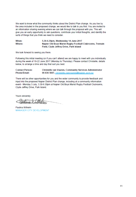
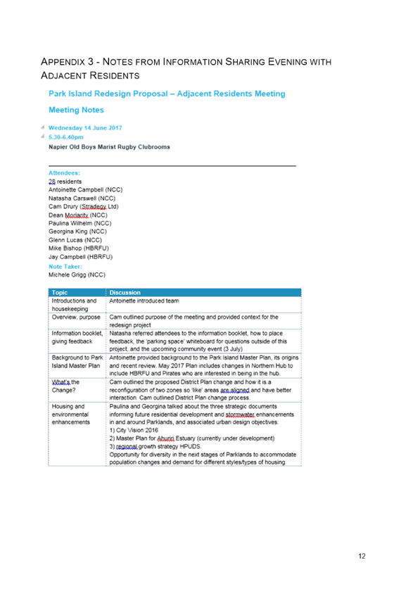
4.4 Consultation with Residential Parties
Adjacent owners/occupiers and other
residents in the Parklands and Tamatea areas were provided an opportunity to
provide feedback on the redesign and reconfiguration proposal during June and
July 2017. Feedback from this initial engagement was to help inform the
proposed Plan Change.
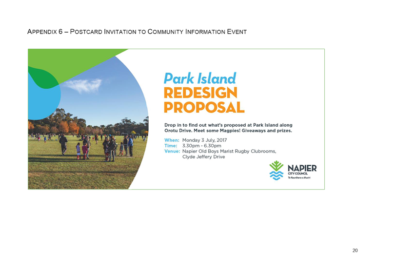
Adjacent residents were personally invited
to an information sharing evening in mid-June 2017. They were also welcomed to
meet individually with Napier City Council (NCC) planning staff. Six parties
took this opportunity up.
A second community information evening was
held with invitations extended to adjacent residents, all other Parklands
residents, and a portion of residents along Westminster Avenue. In addition,
notices about the community meeting were distributed through key contacts and
locations within the Tamatea community. Information about the proposed redesign
and reconfiguration was posted on NCC’s website, providing residents in
the area (and more widely) with a further opportunity to seek information
and/or provide comment.
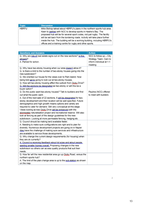
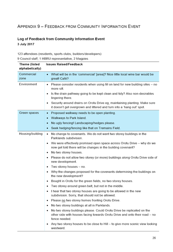
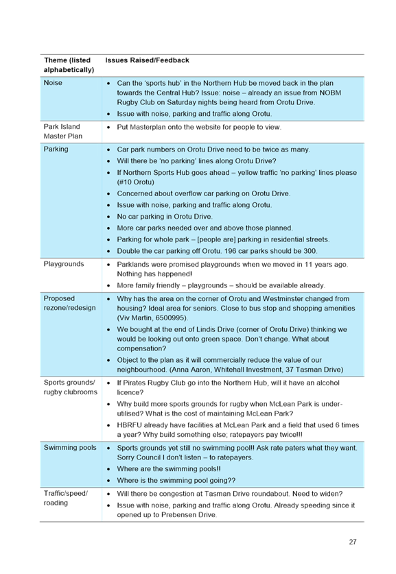
Issues raised by residents attending the
information sharing sessions was wide reaching. A large portion of the feedback
centred on concerns about the possibility of two-storey housing in the next
stages of Parklands, and the impact this type of housing may have on outlook,
housing quality, and residential amenity. This feedback was in response to a
separate process NCC was undertaking around changing the nature and form of
covenants applying to residential development within the existing zoned and
consented Parklands area.
A number of concerns were also raised
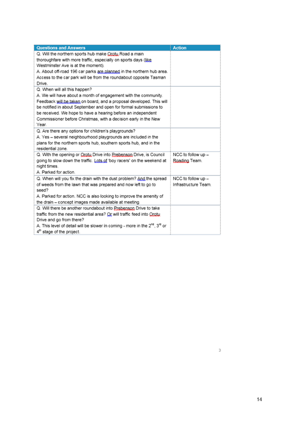
around plans for extra car parking to accommodate users of the Northern Sports
Hub. Residents asked questions about the capacity of the proposed car park in
the hub, the likelihood of overflow parking on Orotu Drive and the impact of
extra traffic generally. Several residents were concerned about the current
excess speeding along both Orotu and Prebensen Drives.
Some residents were interested in hours,
hireage and licensing arrangements for the clubrooms envisaged to be
established in the Northern Sports Hub area.
Residents were generally supportive of the
greenspaces, neighbourhood playgrounds and linkages for pedestrians and
cyclists proposed for the area as part of the Master Plan.
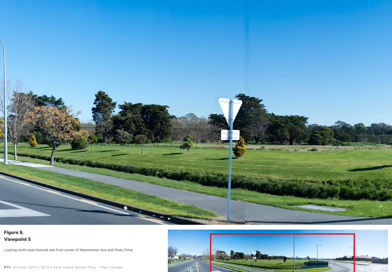
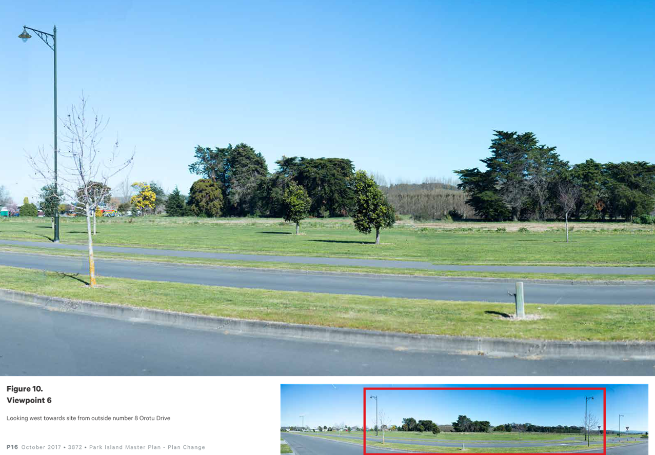
In terms of the visual impact implications
of the reconfiguration, the more focused one-on-one sessions raised concern
around changes in outlook, the location and type of potential two-storey
houses, interruptions to landscape and skyline views towards the west/north
west and treatment of the interface along Orotu Drive.
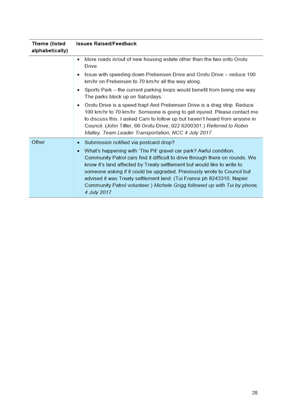
There was interest in the likely timeframe
and sequence of the proposed District Plan Change and development of the new
Parklands area and Northern Sports Hub. All participants in the initial stage
of engagement were advised of the opportunity to make formal submissions on the
District Plan Change following public notification.
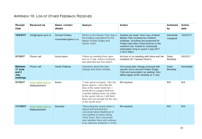
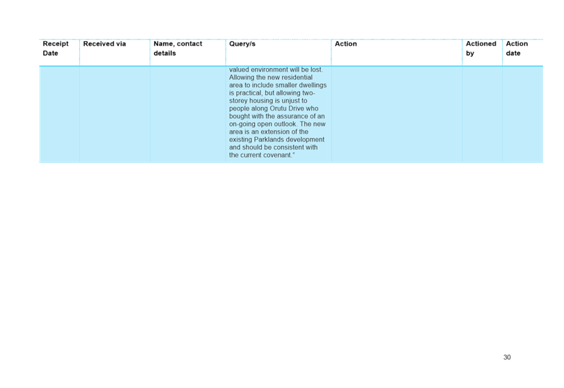
A record of all community engagement is
provided in Appendix 4.
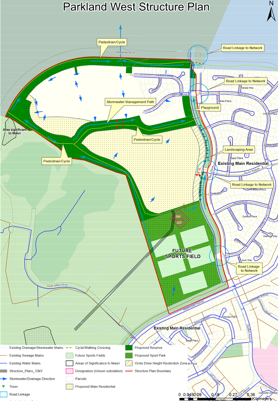
5. RE-CONFIGURATION
OF ZONES
The proposed reconfiguration
will result in an area of (approx.) 13ha zoned Sports Park, 14ha Reserve Zone
and 19ha Main Residential alongside the existing northern Main Residential
Zone.
Combined with the adjoining
existing consented area, the consolidated residential area is expected to
accommodate in the order of 500 lots based on a proposed yield of 15 dwellings
per hectare (rather than the more traditional basis of 12 dwellings per hectare
previously used). This is approximately 150 lots greater than the indicative yield of 345
dwellings (Figure 6 HPUDS2017) i.e. the number of dwellings expected to be
accommodated west of Orotu Drive, and 170 lots greater than the potential yield
of the existing configuration[1].
This section of
the evaluation considers:
‘Whether reconfiguring the Sports Park and Main Residential
Zones alongside Oruto Drive is the most appropriate way to achieve
the purpose of the RMA’.
The following matters are considered as
part of this exercise:
Councils statutory role in managing
sports grounds and urban growth,
Why the Park Island Master
Plan was reviewed,
What was considered in
arriving upon the proposed reconfiguration,
o Sports demand and the sports
clubs/organizations own preferences and willingness to commit to opportunities
within Park Island,
o Changes in visual outlooks,
o Servicing and the potential
for any increased effects in terms of stormwater management in response to an
expanded Main Residential Zone in particular,
o Traffic generation and
effects along Orutu Drive,
o Land suitability
o Provision for Specific
Outcomes via a Structure Plan
Will there be sufficient
sports ground?
Does the Plan Change give
effect to the Regional Policy Statement?
5.1 Councils Statutory Role in Managing Sports
Grounds and Urban Growth
The purpose of the RMA is to promote
the sustainable management of natural and physical resources. In this regard, sustainable
management is defined in
section 5(2) as:
managing
the use, development, and protection of natural and physical resources in a
way, or at a rate, which enables people and communities to provide for their
social, economic, and cultural well-being and for their health and safety
while—
(a) sustaining the
potential of natural and physical resources (excluding minerals) to meet the
reasonably foreseeable needs of future generations; and
(b) safeguarding the
life-supporting capacity of air, water, soil, and ecosystems; and
(c) avoiding,
remedying, or mitigating any adverse effects of activities on the environment.
Managing and providing for urban growth as
well as facilitating the delivery of recreational facilities is clearly
consistent with enabling people and communities to provide for their social,
economic, and cultural well-being and for their health and safety.
This is further mandated in section
31(1)(aa) pertaining to the functions of a District Council, where ensuring that there is sufficient development capacity
in respect of housing and business land to meet the expected demands of the district
is a specific function Councils are required to achieve.
In the context of this proposal it is actually the
‘way’ in which the natural and
physical resources concerned are managed and developed - in that the District
Council is reviewing the configuration under which it plans to deliver
recreational facilities and consequently also provide capacity to manage
housing rather than introducing entirely new zones and activities.
5.2 Why Was the Park Island Master Plan
Reviewed?
Development
of Park Island commenced in 1981 and it is now an important hub for sport in
Napier. In 2013 a Master Plan was completed to guide further development taking
user needs and aspirations into account. The outcome of this process resulted
in a Southern, Central and Northern Sporting Hub - the Northern Sporting Hub
being the area of the Sports Park Zone subject to this Plan Change.
Since
the adoption of the 2013 Park Island Master Plan there have been substantial
changes in user aspirations and increased acceptability of artificial turf
pitches along with intensive and co-use of these pitches by various sporting
codes, rather than the traditional reliance on low intensity use of a large
number of grass pitches.
Combined,
these factors were identified to have the potential to give rise to an over
allocation of single types of sports ground facilities as promoted in the
original 2013 Master Plan. This could in turn give rise to affordability issues
and would not reflect the efficient use of the land resource. It was for this
reason that the Council commenced a review of the ‘way’ in
which it should develop Park Island. In addition, the tennis community have now
decided not to pursue a tennis hub in this location making a significant
portion of the 2013 Master Plan redundant.
Owing
to the location of the Main Residential Zone on each end of the Northern Sports
Hub in the 2013 Master Plan, the review also considered options and
opportunities for those areas of the Main Residential Zone where subdivision
consent for residential development had not yet been
granted.
The Hawkes Bay Rugby Football
Union Incorporated has now expressed a strong commitment to establish a
community rugby facility in the northern sporting hub and has proposed to
establish it alongside Westminster Avenue and Orotu Drive to link with the
existing Marist Old Boys Rugby Club facility to the west.
While
the aspirations of the Hawkes Bay Rugby Football Union have been a factor in
the review, particularly as they are the first sporting group to commit to
development within the area, this has come about by way of timing, and was not
the primary purpose for the review.
5.3 What Was Considered in Arriving Upon the
Proposed Re-Configuration?
Arriving
upon the proposed re-configuration has been a somewhat two-step exercise, with
the first being a review of the 2013 Master Plan, which focused primarily on
the provision of sport facilities, and the second being the consideration of
broader matters to test its merits as part of the Plan Change process,
including:
Servicing,
Change in visual outlooks,
Traffic generation and effects along Orotu Drive,
Land Suitability.
The following outlines the findings of these exercises.
5.3.1 Review of the 2013
Master Plan
The
overall aim of the 2013 Master Plan was to build on the considerable success of Park Island, both
within Hawke’s Bay and nationally, and to realise its potential through a
cohesive long-term plan that could be implemented in stages to ensure it would meet the current and growing
needs of the community.
For
this reason, the review commenced with a focus on sport demand and its
implications for the most efficient layout of the Northern Sports Hub. Of all
the matters and topics covered in the Master Plan, these are the most relevant
in the context of this Plan Change.
The 2013 Master
Plan and associated quantum of sport ground was developed through a needs
analysis and stakeholder feedback process undertake by Global Leisure Group and
Boffa Miskell and was reported on in Appendices 2 and 5 of the proposed Master
Plan (Appendix 2 of this report):
1. Park
Island Needs Analysis Report, January 2012,
2. Park
Island Mater Plan, Sport Stakeholder Feedback and Suggested Changes to Draft
Master Plan, May 2012.
To commence the review in 2016, a further
issues and options and needs analysis process was undertaken and is reported on
in the November 2016 report prepared by Global Leisure Group provided in
Appendix 6 of the proposed Master Plan (Appendix 2 of this report). Key changes
in demand between the original demand analysis and the 2016 analysis were then
summarised in the March 2017 report provided in Appendix 5 of this report and
include the following.
Tennis
has indicated that Park Island is not now part of its future plans for the
sport,
Although
Napier Pirates Rugby and Sports Club has reported no growth of membership since
2011, it has insufficient fields at Tamatea Park and so the Club’s
activities are fragmented with games split between Tamatea Park and Park
Island. Tamatea Park suffers from chronic over-use with two Saturday senior
games (3 hours per week) plus training loads (close to 20 hours per
week),
Hawkes
Bay Rugby Union does not anticipate significant growth in player numbers, and
is now in a stable state. Growth in juniors is continuing but is slowing.
Senior numbers are in decline,
Napier Old Boys Marist Sports
Club has a stable membership with no major change since 2011 and no foreseeable
change.
Key issues identified as part of the second aspect of
the report included:
Decreasing
senior members,
The
increasing proportion of junior numbers leading to higher peak demand on
Saturday morning,
Overcrowded
and aging administration and stadium facilities,
Lack
of floodlit fields,
Fragmentation of Napier Pirates Rugby
and Sports Club activities and lack of capacity at Tamatea Park.
Options to address these issues included:
Artificial
turf fields,
Co-use
of administration and other buildings,
Installation
of floodlighting,
Relocation of Napier Pirates Rugby and
Sports Club from Tamatea Park to Park Island.
Incorporating
the use of artificial turf into the Master Plan was a common option presented
by stakeholders. In its March 2017 report, Global Leisure Group has
advised that one artificial field can increase useable hours from approximately
10-15 hours per week (for a well-drained natural grass field) to more than 45
hours, enabling demand to be spread across the week.
Enabling greater
use of the same area of land provides opportunity to accommodate demand within
a smaller area, as well as the opportunity to accommodate additional demand
either within existing facilities or within smaller expansions. These
opportunities can be applied to the Park Island Sports Hubs in the following
two ways:
1. Projected
demand can be provided within a smaller footprint,
2. Additional
demand such as relocation of the Napier Pirates Rugby and Sports Club from
Tamatea Park can be accommodated.
The following comments were also provided
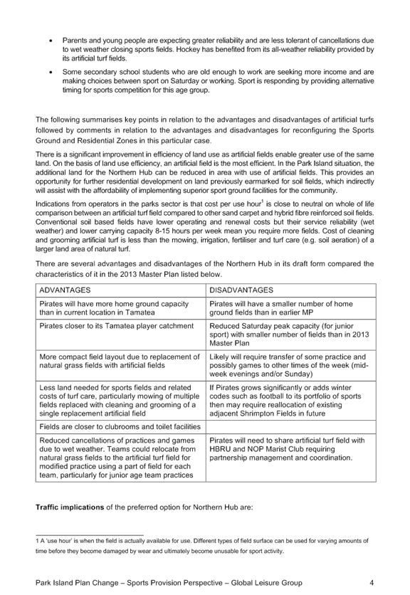
in the March 2017 report in relation to the emergence of artificial turf:
Hockey in
New Zealand was originally driven to adopt artificial turf to remain
internationally competitive. The use of artificial turf has now cascaded down
through all levels of hockey. Hockey now uses a fraction of the land area once
dedicated to providing natural grass fields for the sport prior to adoption of
artificial turf. Over this 30-year period participation in hockey has also
increased. Locally, HB Hockey reflects the national journey in use of
artificial fields 7-days per week and increased participation.
Use of
artificial fields is now more widely accepted than in 2013 by Local Government
for sports other than hockey. Major urban local authorities are investing in
artificial turf where demand pressures are evident, particularly Auckland and
Wellington. Some smaller centres are also adopting artificial fields e.g.
Masterton.
The
Central Football League (the premier regional competition) has most its games
played on artificial turf. Standards for artificial fields is codified in FIFA
regulations.
Standards
for artificial fields for rugby union is codified in IRB regulations. Locally,
HBRU is now adopting artificial fields for training purposes at high
performance and academy levels. Clubs are now wanting to adopt artificial turf,
mostly for training/ practice purposes.
It was also advised from operators in the
parks sector that cost per use hour is close to neutral on a whole of life
comparison between an artificial turf field compared to other sand carpet and
hybrid fibre reinforced soil fields. Conventional soil based fields have lower
operating and renewal costs but their service reliability (wet weather) and
lower carrying capacity 8-15 hours per week mean more fields are required. The
cost of cleaning and grooming artificial turf is also less than the mowing,
irrigating and fertilising a larger land area of natural turf.
In addition to more intensive use, co-use
of sport fields also provides opportunity for the co-use of administration
buildings and other physical resources such as lighting, enabling the
opportunity for more cost effective and higher quality facilities to be
established. This is facilitated in the Master Plan to address the issue of
overcrowded and aging administration and stadium facilities throughout the
city.
In relation to the opportunity to accommodate and
spread demand across the week, Global Leisure Group has also suggested that the
provision of artificial turf will enable greater access to facilities and will
contribute to addressing wider societal trends impacting on sport
participation. For example:
Saturday,
the traditional peak day for sport demand on sports fields is now a busy retail
day (as is Sunday). Many working age players are no longer able to participate
on a Saturday and to an extent on Sundays. This also impacts on availability of
team coaches and managers,
Children
have less free play and have more programmed lives outside of school than
previous generations. Organised sport practices and games are a key occupation
of their after-school time,
Parents
and young people are expecting greater reliability and are less tolerant of
cancellations due to wet weather closing sports fields. Hockey has benefited
from its all-weather reliability provided by its artificial turf fields,
Some
secondary school students who are old enough to work are seeking more income
and are making choices between sport on Saturday or working. Sport is
responding by providing alternative timing for sports competition for this age
group.
Peak traffic movements and
parking demand is also expected to reduce.
Overall, there
is a significant improvement in the efficiency of land use with artificial turf
as opposed to natural turf, and there is potential for positive flow-on effects
in terms of managing and providing associated infrastructure and
enabling/retaining participation in sport. On this basis, and in the Park
Island situation, it is considered by Global Leisure Group that artificial turf
should be incorporated into the Master Plan, and that as a result, land for the
Northern Sports Hub can be reduced in area – while still accommodating
anticipated demand including relocation of Napier Pirates Rugby and Sports Club
from Tamatea Park to Park Island.
In terms of layout,
improved connectivity with the Central Sports Hub was seen as a key advantage,
while the proposed reconfiguration would achieve slightly greater buffer
distances from residential environments and keep like activities
together.
As evidenced in the 2017 Master Plan, the
proposed re-configuration is supported by Global Leisure Group from a sport
provision perspective.
Light spill from
locating the Northern Sports Hub along Westminster Avenue was also considered
as part of the Master Plan review. Here the Master Plan states “with LED lighting technology not only are there are
greater efficiencies, but also significant reductions in light spill from more
directional lighting units. Based on this it is expected that potential effects
on adjacent residential properties would be able to be satisfactorily
resolved.” Further
consideration of lighting is undertaken in Section 6 of this report.
5.3.2 Change in Visual
Outlooks
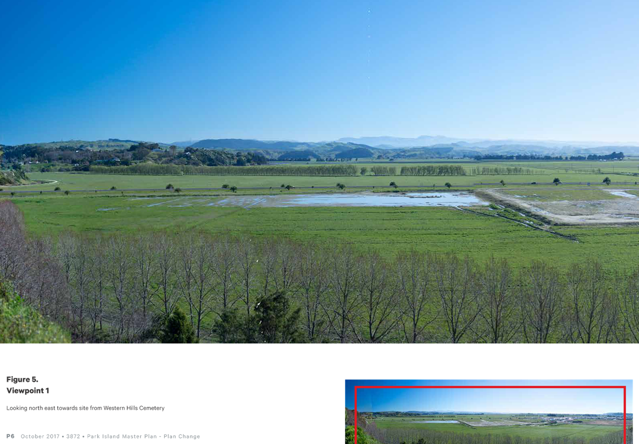
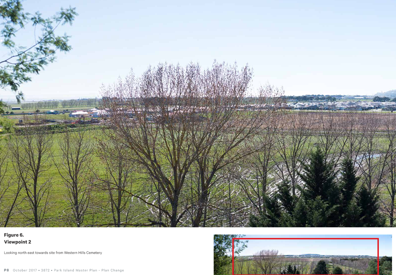
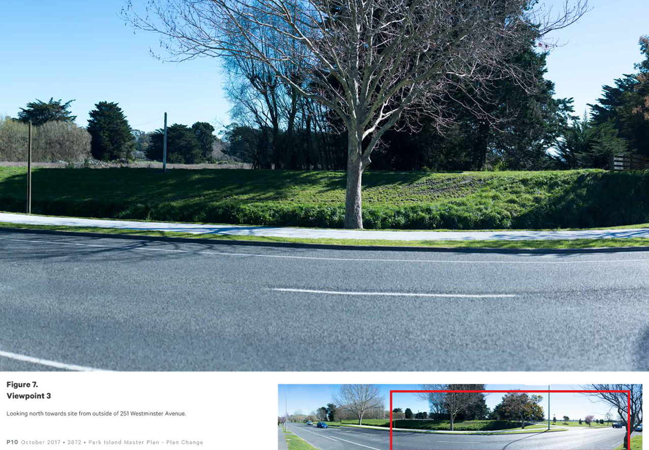
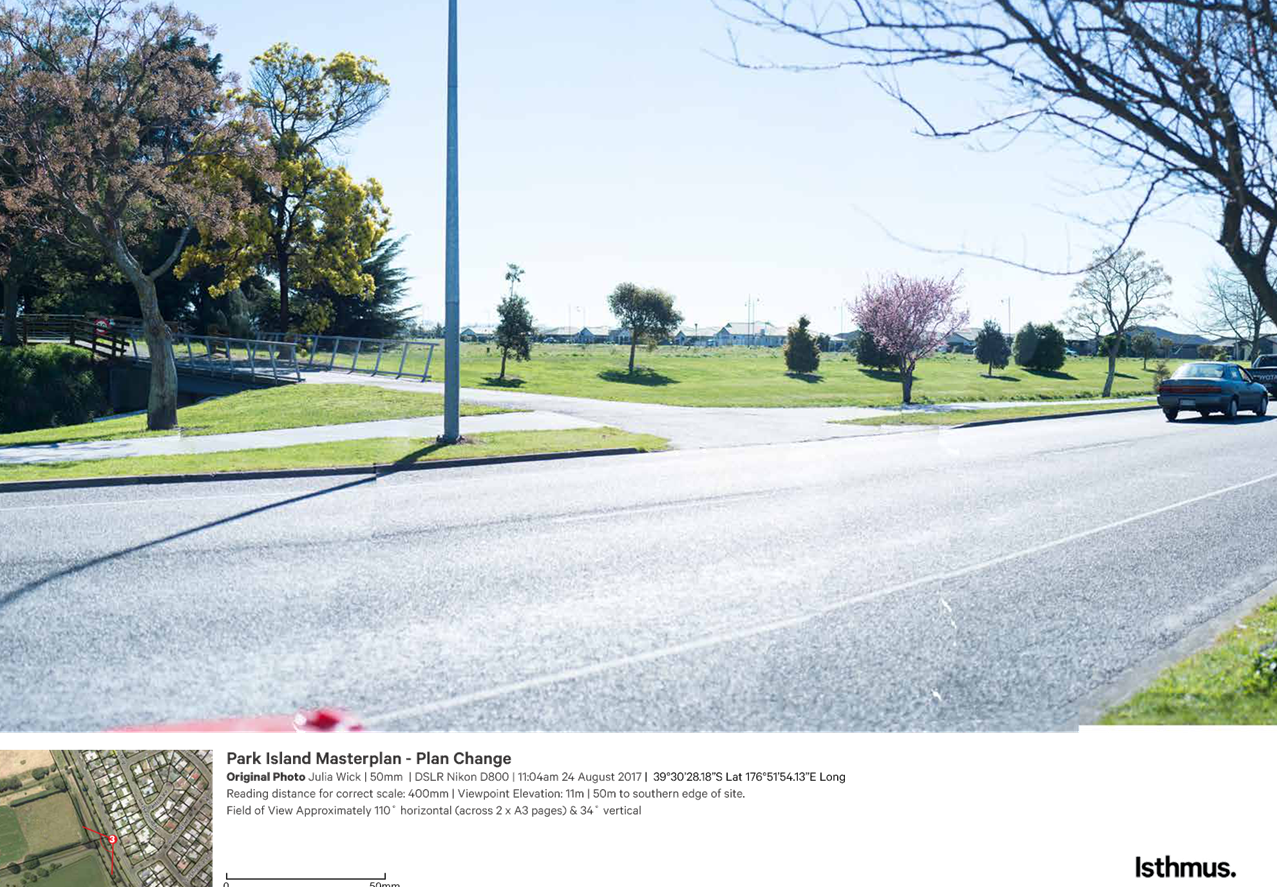
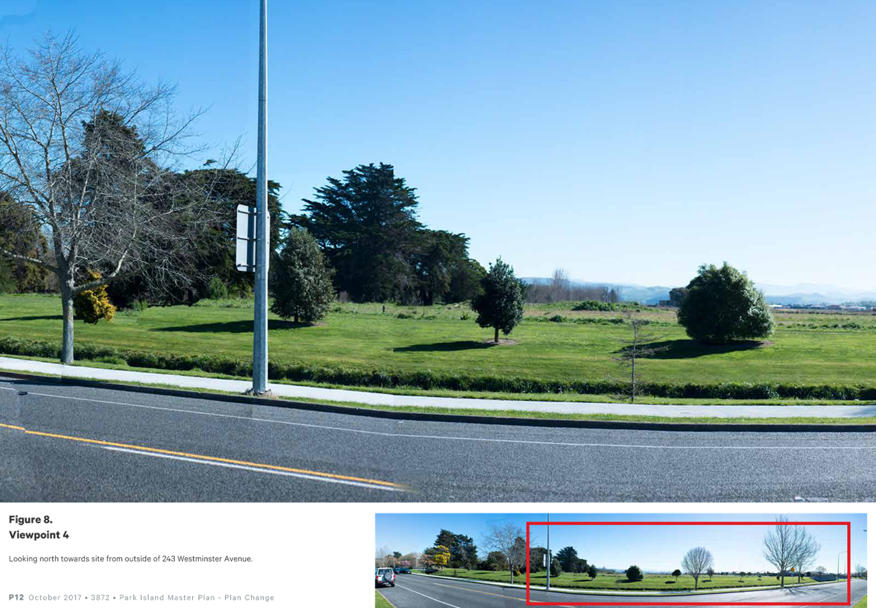
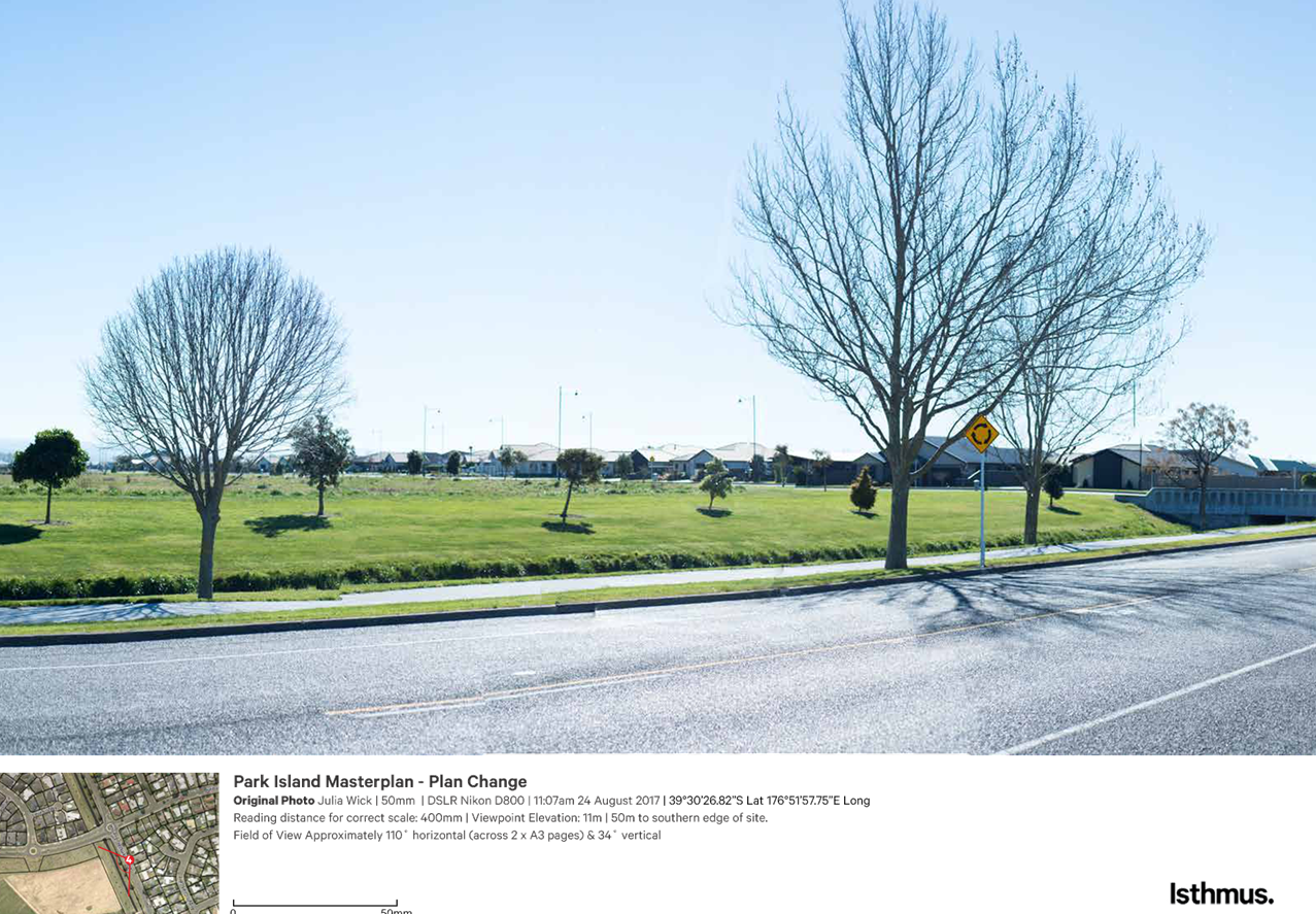
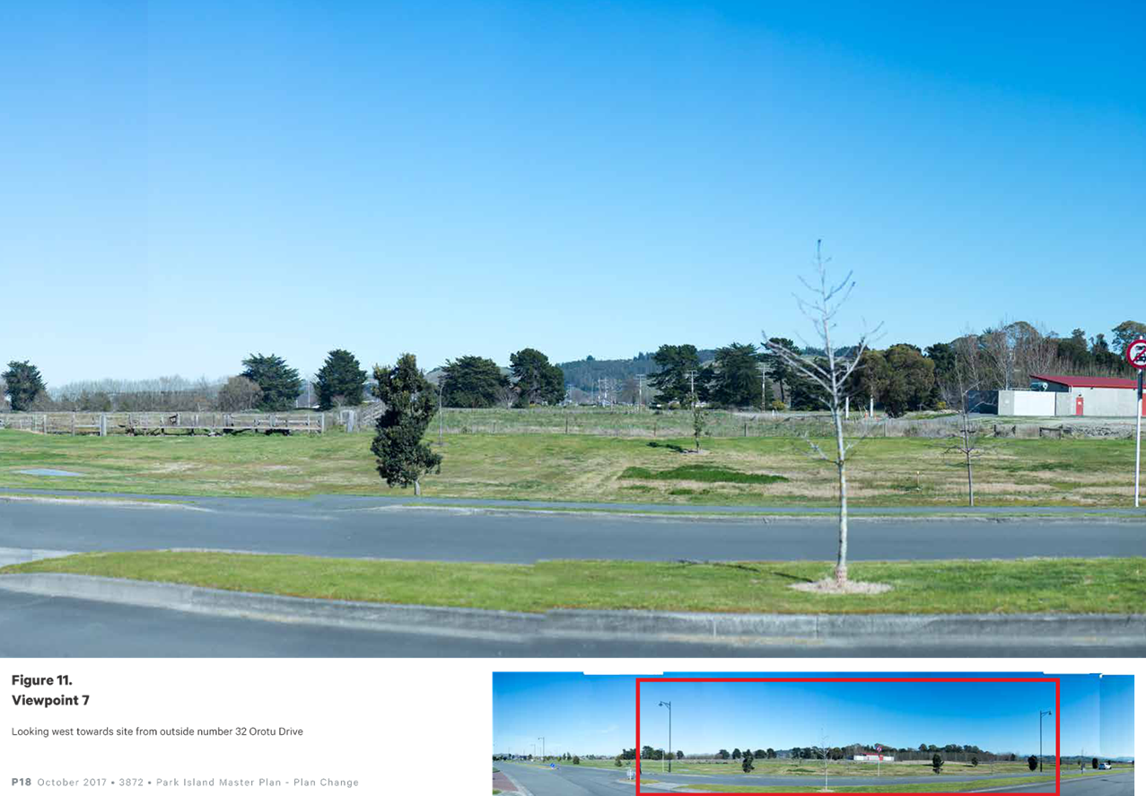
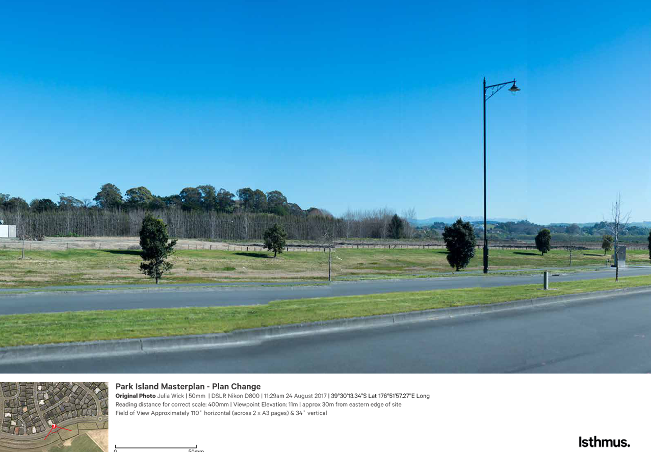
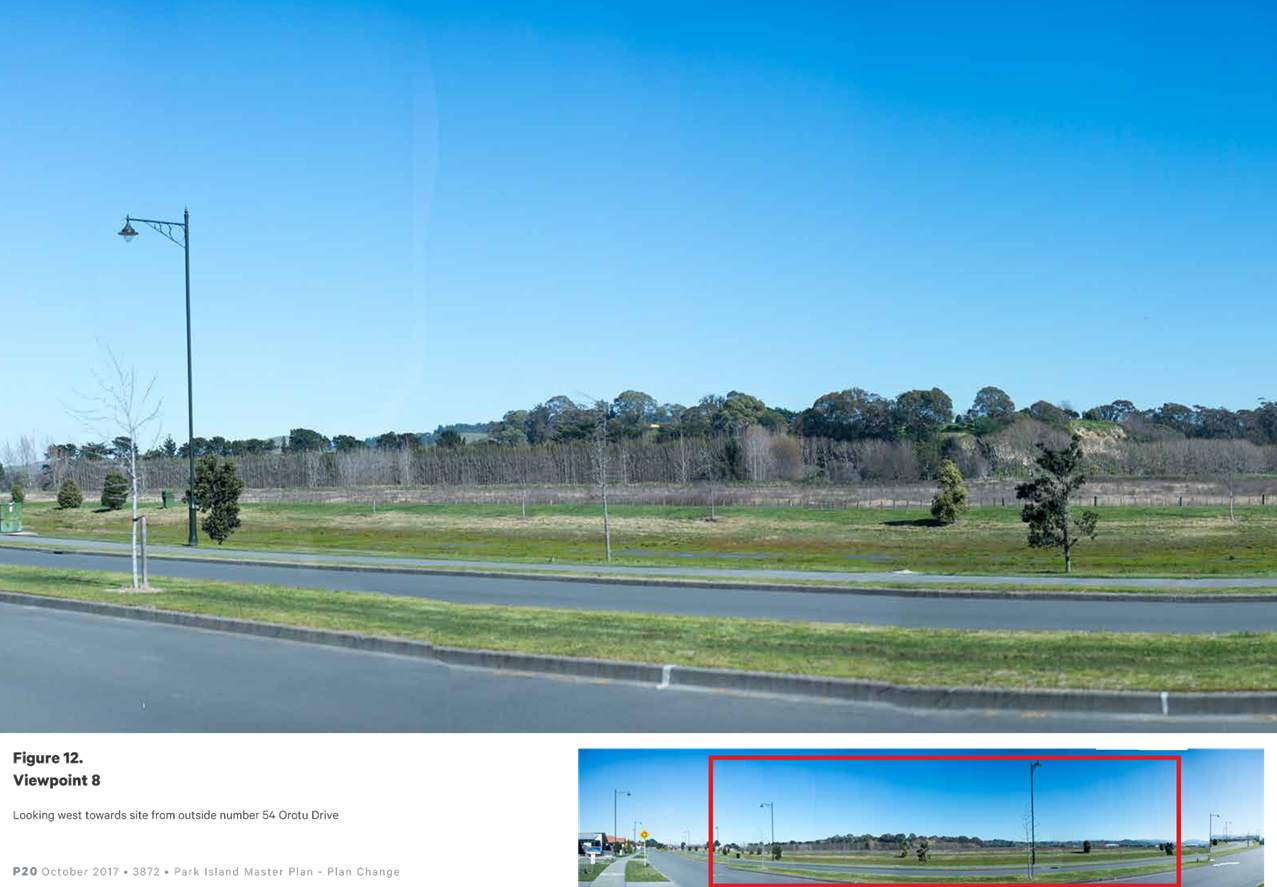
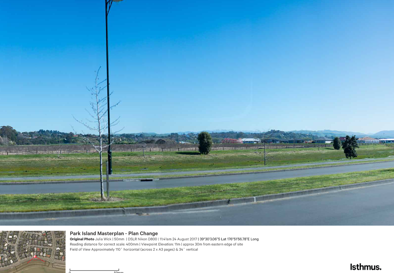
The change in visual outlooks arising from
the proposed reconfiguration has been assessed by Isthmus Group in its report
dated September 2017 provided in Appendix 6. This involved the consideration of the existing character
of the site and locality, and provided a high-level assessment of the likely
visual effects of the proposed Plan Change together with recommendations to
ensure any significant adverse effects arising from the reconfiguration would
be avoided, remedied or mitigated.
The primary matter was the introduction of
residential land use to the area currently zoned Sport Park, and how resulting
structures viewable from the opposite side of Orotu Drive had the potential to
reduce the open character of these viewshafts.
The width of the road reserve (approx. 25 metres) and existing
drainage reserve (approx. 35 metres) along Orotu Drive was considered
sufficient to largely mitigate these concerns however, and further mitigation
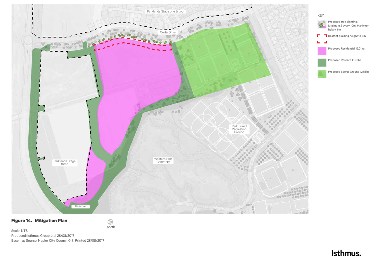
was limited to the following two recommendations:
Clustered groupings of
specimen trees planted along the western edge of Council owned reserve land
along Orotu Drive,
Restrict
building height in the proposed residential zone within a 30m wide strip along
the Orotu Drive interface to 6m (generally single storey residential).
How these
recommendations are best provided for in Plan provisions is considered in
Section 6. However overall, it has been concluded by Isthmus Group that the proposed Plan Change integrates well
with the surrounding landscape and that the overall visual effects will be no
more than minor or inappropriate for the setting.
5.3.3 Servicing
The following outlines the water supply, wastewater and stormwater
servicing solutions associated with the existing configuration (that would go
on to be established in the event that the reconfiguration does not occur),
followed by an assessment of any implications of the proposed re-configuration
on these planned and adopted outcomes. The following has been contributed to
and confirmed by Santha Agas – Napier City Council Team Leader 3 Waters.
Water supply
Orotu
Drive contains a 300mm diameter PVC trunk main laid in the berm on the western
side of the road reserve. The existing configuration involves a series of
connections into this infrastructure with reticulation for domestic and
firefighting supply throughout the northern and southern pockets of the Main
Residential Zone and Northern Sports Hub.
Although
the total length of pipe required will be greater for
the proposed configuration compared the existing, this is simply a function of
an increased number of potential dwellings. The length of pipe required per property will be
similar for each layout.
Overall,
Mr Agas has confirmed that there will be no major changes or impacts on the
existing water supply solution or associated infrastructure as a result of the
proposed reconfiguration.
Wastewater
There are two
pump stations located within the berm on
the western side of the road reserve, one just north of Aoraki Road and the
other just north of Akaroa Road. The existing
catchments on the east of Orotu Drive drain in a western direction to the two
pump stations from where the sewage is pumped in a southern direction.
The existing configuration involves the northern and southern areas of the Main Residential
Zone and Northern Sports Hub draining east to these pump stations. Again,
although greater pipe length overall will be required, this is primarily due to
greater yield.
Overall,
Mr Agas has confirmed that there will be no major changes or impacts on the
existing wastewater solution or associated infrastructure as a result of the
proposed reconfiguration.
Stormwater
A minimum floor level of
11.55m was set through the granting of subdivision consent RMS15019, which is
the same minimum floor level applying to the Main Residential Zone east of
Orotu Drive. It is expected that this will apply to other areas of the Main Residential
Zone irrespective of the final configuration, and that these minimum floors levels will be imposed at
the time of subdivision as currently occurs.
The existing stormwater
infrastructure along Orotu Drive consists of a piped and open drainage system.
Primary runoff from development east of Orotu Drive is
drained to a piped system installed on the western side of Orotu Drive between
the road and the open swale drain running alongside and is conveyed to
an overflow channel on the north side of Prebensen Drive.
Secondary
runoff from larger rainfall events drains to the open swale drain along Orotu
Drive and is conveyed to the same overflow channel on the north side of
Prebensen Drive. Stormwater from the overflow channel is pumped to the Ahuriri
estuary via Purimu pump station under Hawkes Regional Council Resource Consent
CD990516Wa, together with runoff from other areas of the City conveyed to this
point via existing networks.
In developing the layout of
the 2013 Master Plan, the Hawke’s Bay Regional Council (HBRC) was engaged
to undertake an analysis of the Taipo Stream and drainage in the area to
identify potential issues and solutions in relation to the potential for
flooding and stormwater management. In terms of the area comprising the
Northern Sports Hub and the residential areas west of Orotu Drive, it was
identified that development of these areas was likely to increase the amount of
runoff and peak flows arriving at the Purimu pump station, however it was
stated that these effects could be mitigated by detention storage within the
development area or increasing the capacity at the Purimu pump station.
In adopting the 2013 Master
Plan and associated residential zoning i.e. the existing configuration, primary
runoff was to be piped to the overflow channel on the northern side of
Prebensen Drive and the majority of secondary runoff to the same channel via
the open swale drain along Orotu Drive. A 600mm to 675mm pipe was/is
anticipated to be required to connect the southern pocket of the Main
Residential Zone.
Runoff from the
reserve to the northwest and along Prebensen Drive drains to a culvert passing
under Prebensen Drive and into a drain running north alongside Long Road, which
ultimately discharges into the Estuary via a pump station. This stormwater flow
path is also planned to receive secondary runoff from the north-east corner of
the Main Residential Zone (under the current configuration). If flows are
greater than the pipe can pass, the stormwater is stored in the road side swale
beside Prebensen Drive, and in extreme rainfall events this storage feature can
‘tip’ stormwater into the Orotu Drive system at the corner of Orotu
and Prebensen Drives.
Ultimately,
runoff from the proposed re-configuration will be managed in the same manner
i.e. primary runoff piped to the overflow channel on the northern side of
Prebensen Drive and secondary runoff conveyed to the same channel via the open
swale drain along Orotu Drive with eventual discharge via the Pirimu Pump
Station (with the exception of runoff from the reserve and the residential area
to the northwest draining to Long Road as outlined above).
Owing to the
expanded residential area however, additional detention is likely to be
required as a mechanism to manage the effects of peak flows on the capacity of
the Pirimu pump station. As outlined above, detention was one of the options
identified by HBRC as an appropriate response to mitigating the effects of peak
discharges.
Compared to the
level of detention already built into the wider stormwater solution to service
the existing configuration, the additional detention that will be required to
accommodate a slightly larger residential Zone under the proposed configuration
is relatively minor, and options are available to accommodate this either within
the development site, the new open swale drain running west-east as shown on
the proposed Planning Map provided in
Appendix 3, the lower area of the existing swale drain along Orotu Drive or the overflow channel on the
northern side of Prebensen Drive. Detailed design of these solutions will occur
at the time of subdivision with any necessary discharge consents/variations
being obtained as required.
Overall,
Mr Agas has confirmed that there will be no major changes or impacts on the
existing stormwater solution or associated infrastructure as a result of the
proposed reconfiguration.
Both Mana Ahuriri and the Hawkes Bay
Regional Council raised interest in the ability to move
more towards low impact stormwater design solutions. As outlined above, different
Council initiatives around this matter are currently in progress. For example, Council has recently notified the “Draft Ahuriri Estuary
and Coastal Edge Master Plan” and is working towards authorising a number
of existing discharges into the Estuary and replacing Resource Consent CD990516Wa.
The collaborative TANK process facilitated by the Hawkes Bay Regional Council
is also traversing the urban stormwater matter at a macro level where more
efficient overall integrated catchment based solutions can be initiated rather
than ad hoc micro level solutions.
These are high level planning
projects from which various methods to improve water quality will be developed
and will fall down to guide development at the subdivision design stage.
Acknowledging that this Plan Change is more of a re-configuration rather than
the re-zoning of a new greenfield area, this process has not attempted to cut
across or pre-empt the outcomes of these higher-level planning projects. Council is increasingly working towards improving
the quality of all its stormwater discharges through a variety of measures, and
the outcomes or
approaches developed as a result of these projects will be implemented
holistically by way of a comprehensive review across the City in the near
future (just as they would have been under the current configuration).
Summary
Previous
processes associated with the 2013 Master Plan and subsequent zoning of the
residential areas west of Orotu Drive has confirmed that feasible water supply,
wastewater and stormwater servicing solutions are able to be implemented, and
it has been under this framework that RMS15019 has been issued and residential
development has commenced.
The proposed
re-configuration has been considered against this existing setting, and it has
been determined that suitable servicing solutions can be achieved. Implementation
and specific design solutions will be refined and secured through the
subdivision consent process.
5.3.4 Traffic Generation and
Effects Along Orotu Drive
The existing configuration involves three access points off Orotu
Drive, one opposite Kapiti Drive to service approximately 219 dwellings/lots as
consented under RMS15019, one opposite Pacific Avenue to service the Northern
Sports Hub and one opposite Tasman Drive to service approximately 112
dwellings/lots.
These access points will remain under the proposed
reconfiguration; however the Pacific Avenue access point will change to provide
access to residential development rather than sports park, and the Tasman Drive
access point to sports park rather than residential development.
Based on an average of 8
vehicle movements per dwelling per day and 500 lots/dwellings within the
expanded Main Residential Zone, Robin Malley (Team
Leader Transportation, Napier City Council) has advised that 4,000 vehicle movements could be expected at the
western arms of the Orotu Drive/Kapiti Drive and Orotu Drive/Pacific Avenue
roundabouts, and that is reasonable to expect a 50/50 split. In terms of the
sport park to the south, 580 vehicles movements can be expected at the Orotu
Drive/Tasman Drive roundabout. How traffic generation may change as a
result of the reconfiguration at these points is illustrated in Figure 6 below.
Figure 6: Changes in Traffic Generation
A number of questions were raised during consultation as follows.
Comments in relation to each have again been provided by Robin Malley.
1. Will there be enough car parking for the
sports hub?
Comment:
The total number of car parks
proposed for the Northern Sports Hub is 196 which is considered more than
adequate for the proposed layout and calculated demand. There is likely
to be an overspill of parking onto Orutu Drive of approximately 100 vehicles at
peak times which would extend about 600m along one side or 300m each
side. This is acceptable and not considered to be a safety or capacity
issue with the existing geometry of Orutu Drive.
The frequency of
“peak” sporting activity times is likely to be once or twice a week
including on the weekend and is expected to be outside the usual peak commuter
and school times on the urban network.
Orutu Drive and the roundabout
intersections were originally designed to accommodate the predicted volumes of
traffic for the whole development and the proposed internal land use changes
are unlikely to exceed the capacity provided. Moving the residential
development to the North may increase the vehicle movements on the section of
Orutu Drive between Pacific Avenue and Prebensen Drive to a higher level than
previously anticipated. This is likely to be the more attractive route
for drivers to and from the area with shorter distances and fewer / easier to
use intersections and is considered beneficial to the operation of the local
area network.
It is also noted that that the 2017 Master
Plan provides for an additional 527 car parks throughout the whole of the Park
Island sporting hubs (including 205 dedicated to the Northern Sports
Hub). These additional carparks are likely to distribute parking demand
more evenly throughout the whole of Park Island, as well as reducing parking
pressures at peak times.
2. Why not access the sports hub from Westminster
Avenue?
Comment:
Orotu Drive has greater spare capacity and
space for on-street parking which tends to spread out from the primary access
to a facility. The provision for the extra approach to the Tasman/Orotu
roundabout is already designated. Access from Westminster Drive would
also require a new bridge across the drain as the existing one lane bridge is
not suitable. Use of the existing roundabout is preferred.
3. Should there be another intersection from the
north-west area of the main Residential Zone onto Prebensen Drive?
Comment:
Firstly,
a left-in/left-out interaction would result in a number of U-turns or
additional trips to/through the Puketitiri Road roundabout. Any new
intersection would therefore have to be full access. A new intersection in this
regard would compromise the movement function of Prebensen Drive and introduce
additional safety issues. The capacity of the Prebensen Drive/Orotu Drive
roundabout has capacity to accommodate the relatively minor increase in traffic
generation arising from the expanded residential area.
4. Is
there any benefit in having an internal access road linking the proposed
parking area for the northern sports hub through to Clyde Jeffery Drive?
Comment:
Unlikely as this would make the
recreational areas more car dominated, introduce additional conflicts and would
save very little in terms of distance. Good walking/cycling paths are
appropriate for these internal links.
Key conclusions in
regard to traffic and effects along Orotu Drive include:
There will be a marginal increase
in vehicle movements at the Orotu Drive/Kapiti Drive roundabout,
There will be a reduction in
potential vehicle movements at the Orotu Drive/Tasman Drive roundabout,
The Orotu Drive/Pacific Drive
roundabout has the capacity to accommodate increased vehicle movements,
The
Northern Sports Hub will provide a sufficient level of on-site car parking,
while the extent of anticipated overflow is not inappropriate and will not
compromise the safety and efficiency of the roading network,
The
proposed access points are the same as would be established with or without the
reconfiguration, and taking the nature of the surrounding roading network into
account remain to be the preferred options,
Peak
traffic in relation to the Sport Park is likely to be less due to the change in
use patterns that are achievable with artificial turf.
The
additional 527 carparks proposed for the whole of Park Island will more evenly
distribute car parking to match demand and overall reduce parking pressure at
peak times.
5.3.5 Land
Suitability
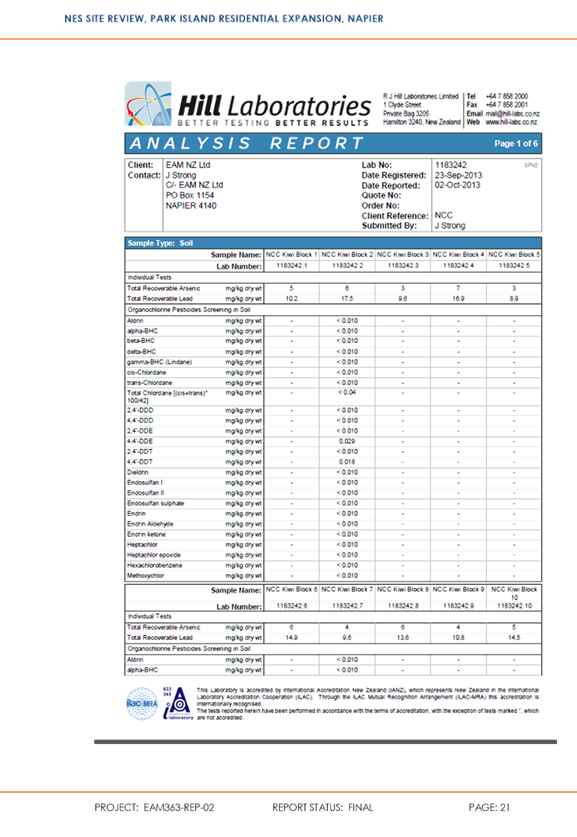
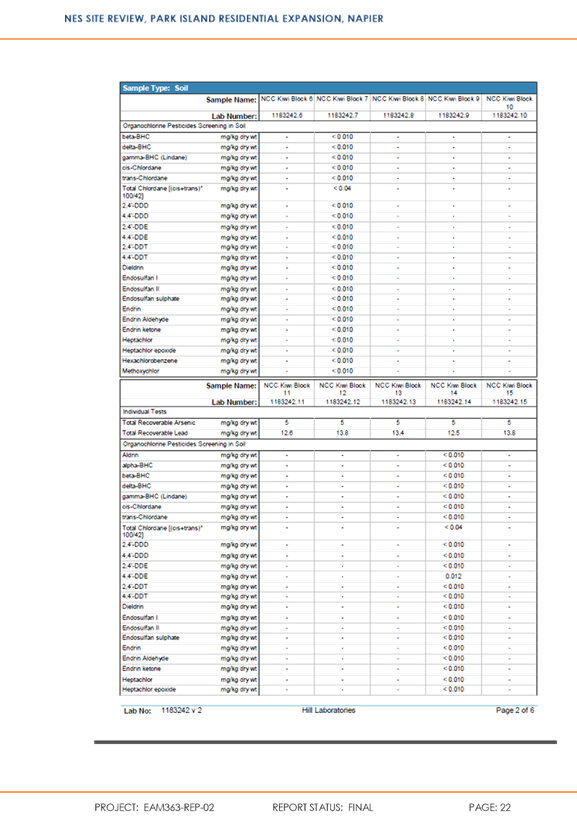
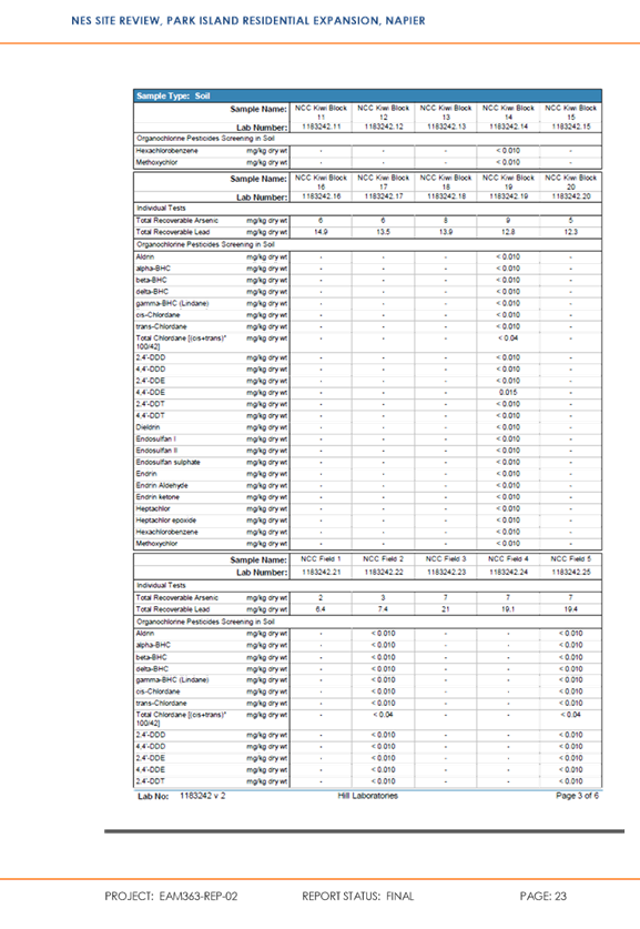
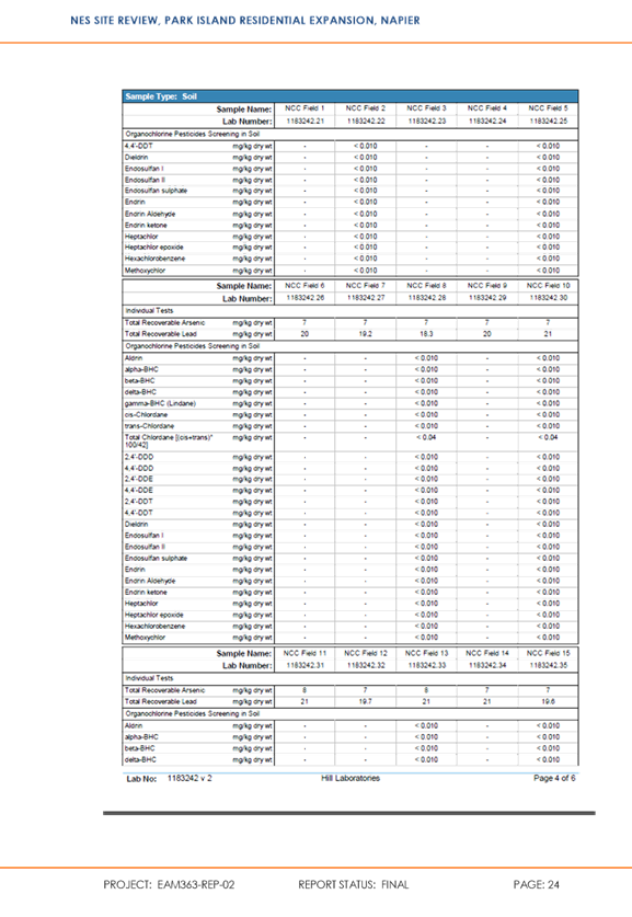
Soil
Contamination
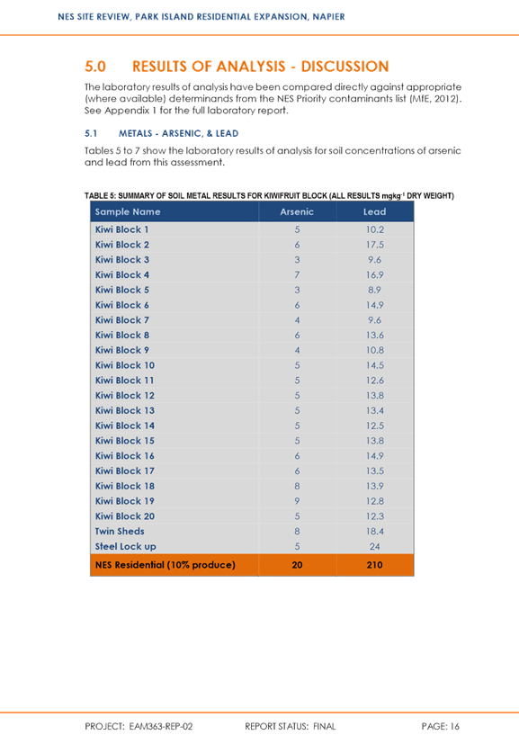
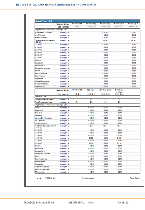
A Detailed Site Investigation under the National Environmental
Standard for Assessing and Managing Contaminants in Soil to Protect Human
Health (the NES) was undertaken by EAM in 2013 over the area of the current Sports
Park Zone adjoining Orotu Drive as part of including the original Master Plan
into the District Plan (by way of Plan Change 10). The land was
previously zoned Main Residential.
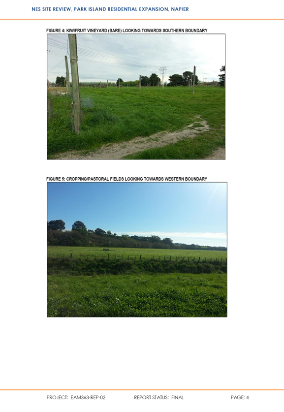
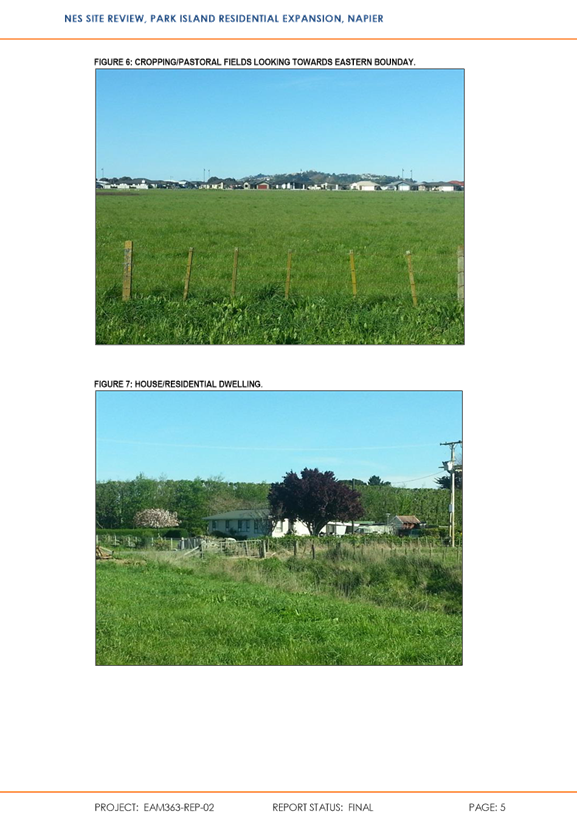
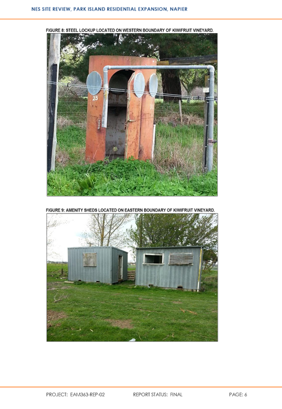
Areas of potential risk where sampling was undertaken comprised a
previous kiwifruit orchard, existing residence with outsheds and
cropping/pastural area. Samples were assessed against the guidelines applying
to a park/recreational land use scenario on the basis of the Northern Sports
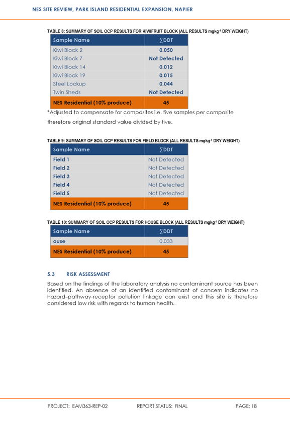
Hub occupying the extent of this area. Following soil testing and laboratory analysis the
assessment concluded that contaminants within the shallow soils are at levels
well below NES guidelines for recreation land use.
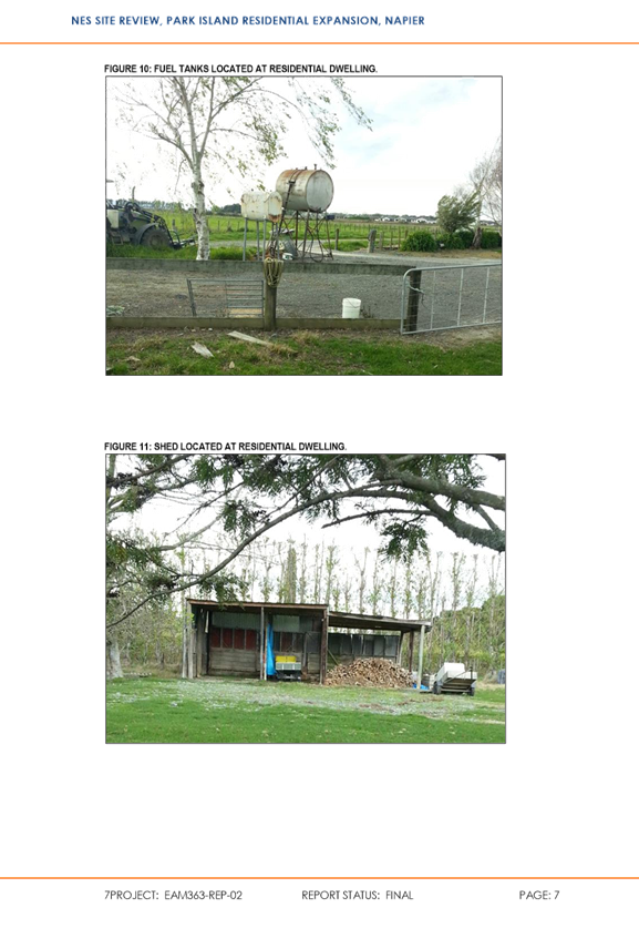
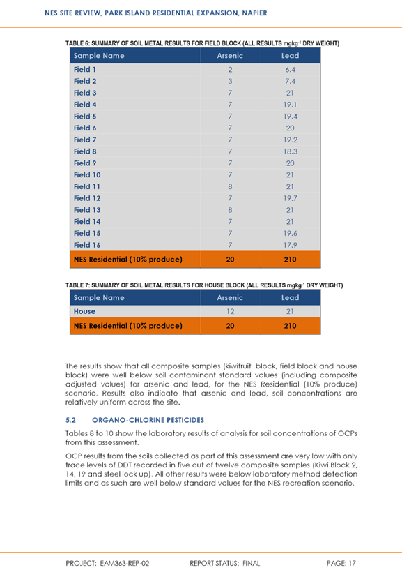
Owing to
the proposed re-configuration of land use as part of this plan change i.e.
residential occurring where sport ground was previously provided for, EAM was
engaged to confirm the situation in relation to a residential use over this
area. The findings are outlined in the report
provided in Appendix 7 where it is concluded that contaminants within the shallow soils were
well below the NES guideline values for the (NES identified) Residential (10%
produce) landuse scenario.
It was
noted however that additional soil sampling and assessment should be undertaken
once/if the existing house and foundations are removed. Similarly, the area
around the residential shed and fuel tanks located in the driveway of the
dwelling should be sampled and analysed once the concrete and hardstand has
been lifted.
Although
the EAM assessment does not do away with the need for further assessment against the NES in these
specific areas at the time of any change of use or soil disturbance, it does
not raise any issues that would render the area inappropriate for the proposed
reconfiguration of Zones.
Following
consultation with the HBRC it was identified that there is potentially an
additional contaminated ‘site’ (what were stock yards and possibly
a sheep dip) in the existing currently zoned Main Residential land in the
southern part of the site. As a result of this knowledge, further work
has been commissioned to identify whether there is any contaminated soil, and
if there is, the extent of the contaminant plume. Irrespective of the
plan change process assessment against the NES will be required over this area
at the time of any change of use / soil disturbance / subdivision. The
appropriate methodology will be determined at that time but if contaminants are
present mitigation measures will be required.
Although
the potential contaminated ‘site’ to the south has not yet
been assessed, the starting point for development of the Sports Park Zone in
this area will be same as for the existing Main Residential Zone i.e. the
proposed reconfiguration can be considered suitable from a potential soil
contamination perspective on the basis that the NES will still apply at the
time of development to manage any soil contamination issues and effects on
human health irrespective of the final configuration.
Natural Hazards
The
following is noted in regard to projected sea level rise as a result of
climatic changes, coastal hazards and liquefaction potential:
The
reconfiguration will occur within an existing urban area where its
susceptibility to the effects of the sea level rise will not change,
The
area is outside coastal erosion and inundation zones (see hbhazards intramaps
below),
The
entire site, together with much of Napier, is located within the ‘Tsunami
Near Source Inundation Extent’, thus the proposed re-configuration does
not change the element of risk in this regard (see below),
On
balance, the re-configuration will place a greater area of the Main Residential
Zone within the ‘Tsunami Distance Source Inundation Extent’,
however the change is marginal and the outcome will be no different to the
existing Parklands residential area on east of Orotu Drive (see below from
hbhazards intramaps),
In
regard to liquefaction, the Hawkes Bay Regional Council has advised that the Ministry of Business, Innovation and Employment (MBIE)
and the Ministry for the Environment have recently published planning and
engineering guidance for potentially liquefaction-prone land and contains
guidance for Councils on resource and building consent applications to assist
with the use and development of potentially liquefaction- prone areas. The
Hawkes Bay Regional Council has highlighted that this guidance may result in
changes in how this risk has been previously managed. However, this is
yet to be determined and this plan change cannot, and indeed need not,
predetermine the outcomes of that process.
As the
entire area west of Orotu Drive, together with most of Napier is located within
a ‘Very High Relative Liquefaction Susceptibility’ area (see
hbhazards intramaps below), the proposed re-configuration does not materially
change the element of risk in this regard or the impact/cost of potential
implications on development.
 Coastal Hazards Zones
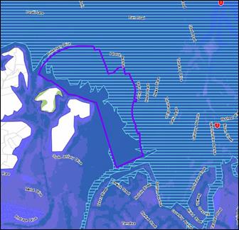
Tsunami Extents
|
|
|
|
|
|
Tsunami
Distant Source Inundation Extent
|
|
|
|
Tsunami
Near Source Inundation Extent
|
|

Liquefaction Susceptibility Areas
Very High
Relative Liquefaction Susceptibility
|
|
Overall, the proposed re-configuration
does not pose any issues in regard to land suitability compared to the planned
and adopted outcomes of the existing configuration.
5.3.6 Provision for Specific
Outcomes Via a Structure Plan
Although existing infrastructure solutions are already in place as
a result of the existing zoning and identified on an existing Structure Plan,
the Park Island Master Plan, District Plan and Code of Practice (for
Subdivision and Land Development) will also act to guide the provision of
infrastructure solutions. Although the proposal is therefore essentially
a minor reconfiguration of an existing zoning pattern, a Structure Plan has
nevertheless been prepared to give effect to Policy UD10.1 of the Regional
Policy Statement. This is provided in Appendix 8 and illustrates:
The
proposed Zones,
Road connections with
the surrounding road network,
Relevant
infrastructure and services,
Indicative drainage
paths and land for stormwater management,
Land for recreation
and social infrastructure,
Indicative landscape
planting and building height restriction areas as recommended by Isthmus Group
in relation to the reconfiguration of Zones,
Indicative pedestrian
walkways and cycleways,
Areas of significance
to Maori,
Existing designations
and overhead powerlines.
This will be included in the District Plan
as Appendix 27A. Although the same area is covered in Appendix 27, this Appendix will
remain unchanged as it also applies to the Park Island area on the corner of
Wharerangi Road and Westminster Avenue that has not yet been developed.
5.4 Will there be Sufficient Sports Ground?
Global
Leisure Group has stated in its March 2017 report that the Council can be be confident that sufficient facilities
will be provided to meet the current and growing needs
of the community on the basis that:
Provision
of more floodlit artificial facilities will increase useable hours by 3 to 5
times, therefore foreseeable demand at Park Island from current users and
anticipated future users (e.g. HBRFU and Pirates) at Northern Hub can, and will
be, met,
Growth
in demand can be accommodated through conversion of remaining natural turf
facilities within Park Island to artificial turf,
The
same strategy of introducing artificial turf can be applied to other parks in
the NCC network to increase overall capacity.
5.5 Does the Plan Change Give Effect to the
Regional Policy Statement?
It
is stated in Section 75(3)(c) that a District Plan must give effect to any
Regional Policy Statement (RPS). Here Chapter 3.1B contains a suite of
provisions relating to Managing the Built Environment.
These
provisions set a vision for compact and well-designed urban
developments within defined urban limits so as to limit encroachment
onto the Heretanga Plains soil resource. They seek a staged approach to
releasing different areas of land for development in order to ensure optimal integration with public
infrastructure, as well as a balanced supply across different areas of
Napier, Hastings and Havelock North in order to provide opportunities for all
levels of the market. In summary:
Objective UD1 seeks to establish a compact
and strongly connected urban form that;
o Avoids, remedies or mitigates reverse
sensitivity effects,
o Avoids unnecessary encroachment on
versatile land,
o Avoid or mitigates increasing the
frequency or severity of risk to people and property from natural hazards,
Objective UD 2 seeks to accommodate growth
through the intensification of residential areas,
Objective UD3 states that land
requirements for the growth of business activities should be provided in a
manner consistent with Objective UD1,
Objectives UD4 and UD5 see to
manage urban development through a planned and staged manner that is integrated
with the provision of strategic and other infrastructure,
Objective UD6 seeks to ensure that the planning and provision of
transport infrastructure is integrated with development and settlement patterns
while limiting network congestion, reducing dependency on private motor
vehicles, reducing emission of contaminants to air and energy and promoting the
use of active transport nodes.
The
Park Island / Parklands area is already identified in Policy UD4.3(b) as an
appropriate residential growth area having been identified in both the original
HPUDS document and subsequent 2017 review.
HPUDS2017 emphasizes that its urban growth maps are indicative
only, and the purpose is to provide guidance to the Territorial Authorities for
when they are developing Master Plans and/or Structure Plans to give effect to
the Strategy and RPS. Final areas and configurations are expected to be
determined by the Plan Change process.
The area’s suitability for residential development has been
further validated by the existing zoning pattern and issue of subdivision
consent RMS15019. Development within the subject area, regardless of the
configuration, is therefore already provided for and anticipated under the
RPS.
The proposed plan change is not so much a rezoning of land but a
reconfiguration of the zones that enable more efficient and intensive use of
the same area of land for both projected additional sports demand and
residential use. The reconfiguration therefore helps prevent urban sprawl
and encroachment onto versatile land on the city fringe (or indeed elsewhere).
Given then that the same land use activities will essentially
occur within the same overall footprint, the following assessment will be
limited to the Policies contained in Chapter 3.1B of the RPS. Indeed, the
proposed reconfiguration will give rise to essentially the same outcomes as the
existing configuration in terms of the remaining Policies of the RPS pertaining
to matters such as the sustainable management of coastal resources, effects on
conflicting land uses, groundwater quantity and quality, surface water
resources, natural hazards, maintenance and enhancement of physical infrastructure
and Iwi/hapu matters.
Furthermore, as the proposed plan change is not so much a rezoning
of land but a reconfiguration of the zones, the level of detail provided
acknowledges the proposal is within an area already identified as an
appropriate residential growth area and where existing and planned
infrastructure already exists. The relatively minor increase in potential yield
is nevertheless still considered.
|
Regulatory Committee - 22 November 2017 - Attachments
|
Item
1
Attachments
a
|
The proposed reconfiguration will raise no issue with the original
intent of the Parklands greenfield growth area
or the basis on which it was originally advanced. Furthermore, although the
proposal will involve an increase in potential yield, there are benefits in
terms of the efficient use of infrastructure and maintenance of supply in that
the minor increase will result in a more intensively developed and compact city
within existing urban limits. Indeed, the expanded area:
Has already been identified as a suitable
greenfield growth area in HPUDS and the RPS;
Can be serviced by existing and
already planned infrastructure,
Is located in close proximity
to established social infrastructure including schools, commercial services,
sport and recreation facilities and public open space,
Has good access to main
arterials and areas of employment,
Will continue a proven pattern
of active and continuous development.
Overall, it is considered that the proposed
reconfiguration gives effect to the RPS.
5.6 Summary
To date, Section 32 case law has
interpreted ‘most appropriate’ to mean “suitable, but not
necessarily superior”[2].
Overall, the
proposed reconfiguration is considered an appropriate way to achieve
the purpose of the RMA. The following key points have been
considered in coming to this view:
The
reconfiguration will improve the integration and connectivity of sport
facilities within Park Island,
The area of the Sports Park Zone will be
large enough to meet the
current and growing needs of the community,
Effects associated with changes in visual
outlook will be less than minor and appropriate for the setting,
Development will
be serviced by existing and planned infrastructure solutions, and there will
essentially be no change in this regard as a result of reconfiguring the
zones,
Traffic related
outcomes will remain within those planned and anticipated for the area,
There will be no
increase in risks associated with soil contamination or natural hazards as a
result of zoning areas of the Sports Park Zone to Main Residential,
The proposal continues to give effect
to the RPS,
That due to all of the above factors the
proposed plan change is considered to serve the purpose of sustainable
management of natural and physical resources.
6. APPROPRIATENESS
OF PLAN PROVISIONS
Having determined that the proposed reconfiguration is an
appropriate way to achieve the purpose
of the RMA, it is a matter of determining whether the provisions
of the proposal are the most appropriate way to achieve this in terms of their
efficiency and effectiveness. Again, Section 32 case law has interpreted
‘most appropriate’ to mean “suitable, but not necessarily
superior”.
In the context of this
particular Plan Change, as the proposal is essentially a ‘switch’
of zones that carry with them established provisions to provide for specific
landuse outcomes and to avoid, remedy or mitigate adverse effects, it is really
only a matter of determining the need for any amendments to these existing
Policies, Rules and Conditions.
In this regard, the assessments above have pointed towards the
matters around which focus is required to undertake this evaluation. These
include:
(1) Visual outlook along the interface of the new Main
Residential Zone along Orotu Drive,
(2) Noise arising from the Sports Park Zone in its new
location,
(3) Light spill arising from the Sports Park Zone in its new
location.
The appropriateness of the existing Rules of the Sports Park Zone
to deliver the intentions of the Park Island Master Plan and Condition 48.12 in
particular, which limits the floorspace of buildings are also relevant matters.
Taking the above assessments into account, the way in which the
existing provisions of the zones manage all other matters, including traffic
and on-site car parking is considered an appropriate way to achieve the
reconfiguration.
The following examination will therefore focus on (1) – (3)
above together with the rule framework of the Sports Park Zone to deliver the
intentions of the Park Island Master Plan. Plan Change edits arising from this
exercise are provided in Appendix 9.
6.1 Visual Outlook Along the Interface of Orotu
Drive
The change in visual outlook from Orotu Drive has been assessed by
Isthmus Group in its report dated September 2017 provided in Appendix 7, where
the following was recommended as part of a mitigation strategy:
(1) Clustered groupings of specimen
trees planted along the western edge of Council owned reserve land (as shown
indicatively in Figure 7 below),
(2) Restrict building
height within a 30m wide strip along the Orotu Drive interface (as shown in
Figure 7 below) to 6m (generally single storey residential).
No other recommendations
were made in regard to any other matters, or other ‘edges’ of the
zones.
Figure 7: Building Height Restriction
Zone

Planting within the
Reserve along the western side of Orotu Drive will be provided for within the
commentary on the Master Plan itself in Appendix 34 as follows, as well as via
a new Method to be inserted in relation to Objective 4.7 of the District Plan
as shown further below:
Changes to
Appendix 34
|
Appendix
34 Park
Island Master Plan
|
Explanation
The Park Island Sports Ground is
the focus of many of the sporting codes undertaken within the city. With
changing sports requirements including overlapping between sporting codes, and hybrid
sports, together with the need to make better and more efficient use of
existing sports grounds, the Council has undertaken a master plan for Park
Island to ensure that the City's sporting needs are provided for over the next
20+ years.
The Park Island Master Plan has
been developed by clearly identifying user needs and demands, and considering
the potential for better use of the existing sports park land within the city
and the ability to extend the boundaries of Park Island. The stakeholder consultation
has provided opportunities to gauge what currently makes Park Island successful
and to identify where provision for sports and related facilities as well as
passive recreation can be improved to deliver greater value to users. It also
considers Park Island in its broader context and the relationship and linkages
to surrounding areas, particularly Parklands subdivision.
Currently,
‘sportsville’ concepts are being developed around the country
providing opportunities to develop more sustainable clubs sharing facilities
and services. The ‘sportsville’ concept is the basis of the Park
Island Master Plan with reorganisation and development focused around three
‘sports hubs’. Two of these, the Southern Sports Hub and the
Central Sports Hub essentially involve reorganisation and some re-development
of the current Park Island facilities. The Southern Sports Hub is centered
around the existing Hockey Turf facilities and the Football Stadium. The
Central Sports Hub incorporates the Marist Rugby Club and adjoining ruby fields
and also the Shrimpton Fields. The Northern Sports Hub will be a new
development on a ‘greenfields’ site to the north of the Central
Hub.
The Northern Hub will adjoin the
next stages of the Parklands subdivision and the master plan has considered how
the interface between the two activities can be successfully achieved. In
particular, planting as recommended in the Isthmus Group September 2017 report
will be undertaken by Council within the Reserve alongside Orotu Drive ahead of
development wherever practicable within this area. Vehicular access to the
Northern Hub will be off Orotu Drive. A network of existing and new pedestrian
and cycle paths will provide internal linkages between the sports hubs and also
provide new opportunities for informal recreational use of Park Island.
The overall aim of the master
plan is to build on the considerable success of Park Island, both within Hawkes
Bay and nationally, and to realise its potential through a cohesive long term
plan that can be implemented in stages. The concept revolves around the sharing
of facilities and recognising that the focus of Park Island is on outdoor sport
and recreation but that it has the potential to be ‘more than a sports
park’ through enhancement of its facilities and infrastructure for
passive recreation. The overall concept is based on a series of separate but
interrelated ‘sports hubs’, which are linked together by a network
of multi- use pedestrian walkways and cycleways.
To remain viable a master plan
has to be dynamic and have a degree of flexibility because it needs to be able
to respond to change as well as guide it.
Changes to
Objective 4.7 Methods
Objective 4.7 states:
“To maintain and enhance
residential amenity through the retention and planting of trees within the
residential environment.”
The following
changes to the Methods associated with Objective 4.7 are proposed in order to
provide for the implementation of Master Plans where these involve specific
works within Reserves.
Methods
(1) District
Plan Rules.
(2) Other
Methods.
The Council will prepare a
brochure explaining the contribution of trees to the residential environment,
offering guidance to the public on the planting, maintenance and suitability of
tree species and explaining how and why certain activities can cause harm to
trees.
The Council will work with local
communities to develop road planting and maintenance programmes. In addition, a
policy document for work affecting trees adjacent to roads and public places
will be prepared by the Council.
Council will also undertake
planting within Reserves in accordance with Master Plans.
In terms of building height, this is already regulated
through Condition 5.17 as follows, and in the area concerned allows for a
maximum building height of 8m.
The options that present
themselves are therefore:
(1) Do
nothing i.e. retain Condition 5.17 in its current form,
(2) Amend
Condition 5.17 to accommodate the recommendations of Isthmus Group,
(3) Consider
further amendments in addition to those recommended by Isthmus Group.
On the basis of the expert
opinion of Isthmus Group, and in acknowledging the matters raised in
consultation, the ‘do nothing option’ is not considered
appropriate.
Similarly, as Isthmus Group
have not recommended any further mitigation that would raise the need to amend
other bulk and location Conditions as provided for under Option (3), Option (2)
of amending Condition 5.17 to limit height to 6m within a 30m wide strip along
the Orotu Drive interface is proposed as follows:
5.17 Height
1. The following
maximum height conditions shall apply to all land uses, other than aerials,
lines and support structures:
a) Any
part of a building or structure must not exceed 8 metres in height, except
that:
iii) For
sites within the Orotu Drive Height Restriction Zone as shown on the Structure
Plan in Appendix 27A, any part of a building or structure must not exceed 6
metres in height.
All other sub-clauses of
Condition 5.17 will remain unaffected. Condition 5.17(c) states “where
there is conflict between any of the height control lines or limits, the lowest
height must prevail.”
The expert advice from Isthmus
Group has been relied on to address the concerns raised during consultation in
regard to changes in visual outlook.
6.2 Appropriateness
of Sports Park Zone Provisions
Rule 48.2 provides for the
following to be undertaken as a Permitted Activity within the Sports Park Zone:
1. The
following land uses are permitted provided they comply in all respects with the
relevant conditions in the Sports Park Zone activity table and condition table:
a) Maintenance
and repair of buildings and structures.
b) Recreational
activities.
c) Vehicle
parking areas.
d) Activities
identified in an approved management plan under the Reserves Act 1977.
e) Activities
identified on the Park Island Master Plan in Appendix 34 including commercial
offices and commercial activities ancillary to sports activities undertaken on
the Park.
In terms of (b), Recreational Activities are defined
in the District Plan as:
“means any land and/or
buildings whose primary use is for passive or active leisure, whether
competitive or non-competitive, casual or organised, including shelter, public
conveniences, the use of outdoor school grounds between the hours of sunrise
and sunset, and other accessory buildings”
Sub clause (e) relates specifically to the Park Island
Master Plan in which the area of the Sports Park Zone subject to this Plan
Change is located. Commercial Activities, a referred to, are defined in the
District Plan as:
“means the use of land and
buildings for the display, offering, provision, sale or hire of goods,
equipment or service and includes retailing, travellers’ accommodation,
day care centre and off-licence premises and wholesale liquor outlets, but does
not include education facilities or any business of prostitution”
As previously outlined, the
Hawkes Bay Rugby Football Union are first sporting group to commit to
development within the area. The Master Plan states that Hawkes Bay Rugby Union
needs an operating base including offices for professional staff, meeting rooms
and high-performance training facilities including seminar room, fitness gym, a
covered training area with an artificial surface suitable for rugby activity,
as well as facilities for related services such as sport massage and
physiotherapy.
Although many of these activities are either
identified on the Park Island Master Plan or fall within the definition of
Commercial Offices, Commercial Activities or Recreational Activities as
referred to in the Rule, to ensure the intentions of the Master Plan are
enabled through Rule 48.2, it is proposed to amend sub clause (e) as follows:
e) New
buildings and activities identified on the Park Island Master Plan in
Appendix 34 (including but not limited to; commercial offices, and
commercial activities, gymnasiums, indoor sports facilities and healthcare
centres provided they are ancillary to sports activities undertaken on the
Park as either single or multiunit development activities).
Licensed Premises will continue
to be classified as a Discretionary Activity under Rule 48.7(b), for which
resource consent is required.
Also relevant to the efficient
delivery of sport facilities is Condition 48.12, which limits the maximum floorspace
of buildings as follows:
48.12
Floorspace
1. The
following floorspace condition shall apply to all land uses:
a) The
maximum floorspace of buildings on a site must not exceed 500m2
gross floor area.
b) The
maximum floorspace of buildings identified on the Park Island Master Plan is
1000m2 gross floor area.
The combined floorspace of existing
buildings within the Southern Sports Hub is already in the order of 2,000m2,
and 1,000m2 for the Central Sports Hub. A rule limiting
building floorspace to a maximum of 1,000m2 over the entire Master
Plan area, which includes all three Sports Hubs, is not the most appropriate or
efficient way to enable the provision of already identified and known sport
facilities. This is particularly so when unduly limiting the floorspace of
buildings has the potential to limit the integrated use of buildings by various
codes which in itself would risk one of the Master Plan clearly stated
intentions of avoiding the duplication of facilities.
There are a number of options
to address this as follows:
(1) Do
nothing,
(2) Remove
the limitations,
(3) Amend
the limitations.
As outlined above, the
‘do nothing’ option is not appropriate as any new building within
the Master Plan would require a resource consent despite already being
identified and anticipated in the Master Plan.
Removing the limitations
altogether would result in no controls around the extent of buildings however,
and this would pose a risk of unintended outcomes in the absence of a resource
consent process to properly consider such proposals.
For this reason, it is proposed
to retain a level of control but to amend the current provision. Although there
are a number of options in this regard, the following key criteria have been
considered to arrive upon a proposed approach:
(1) The
specified limit should allow for growth without resulting in overly obtrusive
buildings or compromising the area for sport grounds,
(2) Given
the size of Park Island compared to other Sports Park Zones in the City and
that the Master Plan separates it into three distinct Hubs, limits should apply
on a ‘Hub’ basis.
On the basis of the combined
floorspace of existing buildings within the Southern Sports Hub already being
in order to 2,000m2 without resulting in an obtrusive scale of
building bulk, and that the Master Plan signals the need for additional
buildings in the order of 2,000m2 gross floor area, it is proposed
to amend the limit, per ‘hub, to 4,000m2 in order to enable
the efficient delivery of the Master Plan outcomes.
Condition 48.12 is therefore
proposed to be amended as follows:
48.12
Floorspace
1. The
following floorspace condition shall apply to all land uses:
a) The
maximum floorspace of buildings on a site must not exceed 500m2
gross floor area, except where:
b) In
Park Island the combined maximum floorspace of buildings within
each Sports Hub, as identified on the Park Island Master Plan, must not
exceed is 1000m2 4,000m2 gross floor
area, provided:
i) no
one building shall exceed 2,000m2 gross floor area,
ii) buildings
exceeding 500m2 gross floor area shall be located no less than 30m
apart.
The overall limit of 4,000m2
per ‘Hub’ will provide for the outcomes of the Master Plan, while
the limit of 2,000m2 for each individual building together with
existing provisions around yard setbacks and height will provide a control
around the visual appearance of bulk. This limit has been based around the
approximate size of the new building identified for the Southern Sports Hub.
The proposed separation control
of 30 metres between large buildings is intended to avoid the conglomeration of
bulk without compromising the benefits of consolidation and has been developed
on the basis of the width of a Major Residential Road (18m) with the existing
6m front yard setback on either side to reflect a permitted baseline scenario.
Proposals that do not comply
with these limits would be assessed on their merits and effects though the
resource consent process.
The existing 10m maximum height
and 6m yard setback provisions in Conditions 48.9 and 48.10 will remain. With
these still in place, the proposed amendments are considered to be an
appropriate and efficient way of providing for the outcomes of the Master Plan
while having regard to the maintenance of visual amenity values.
In respect to the visual
outlook from Orotu and Westminster Drives, it is also noted that any built
development within the Northern Sports Hub under these provisions will be
significantly less than the quantum of built development that is currently
provided for under the existing residential zoning of this area.
6.3 Noise Arising
from the Sports Park Zone
Noise arising
from Sports Park Zones is currently regulated by Condition 48.13 as follows:
48.13
Noise
1. The
following noise conditions shall apply to all land uses, other than those
exempted in Rule 57.9:
a) All
land uses within the zone must be conducted so as not to exceed the following
limits at point within a residential zone:
|
Control Hours
|
Noise Level
|
|
0700 to 1900 hours
|
55 dB L Aeq (15 min)
|
|
1900 to 2200 hours
|
50 dB L Aeq (15 min)
|
|
2200 to 0700 hours the
following day
|
45 dB L Aeq (15 min)
|
|
2200 to 0700 hours the
following day
|
75 dB L AFmax
|
b) All
land uses must comply in all respects with the relevant conditions in Chapter
57 (Noise) of this Plan.
These limits are
applied on a consistent basis to all Sports Park Zones within the City, many of
which, like the Sports Park Zone subject to this Plan Change process in its
existing location, adjoin residential Zones. On this basis, no amendments are
considered necessary in regard to the managing the effects of the proposed
reconfiguration.
It is also noted
that under Rule 57.9.1 (b) that recreational activities of a normal
recreational nature such as sporting events and playground activities are
exempted from the maximum noise limits in any case. This type of noise is
likely to be the predominant one generated within the proposed Northern Sports
Hub (irrespective of its location).
6.4 Light Spill
Arising from the Sports Park Zone
Locating the Northern Sports Hub along
Westminster Avenue together with the proposed lighting plan requires light
spill to be considered. Here the Master Plan states “with LED lighting technology not only are there are
greater efficiencies, but also significant reductions in light spill from more
directional lighting units. Based on this it is expected that potential effects
on adjacent residential properties would be able to be satisfactorily resolved.”
Light Spill
arising from Sports Park Zones is currently regulated by Condition 48.14 as
follows:
48.14 Light
Spill
1. The
following light spill conditions shall apply to all land uses other than for
the purposes of illuminating a road:
a) Between
the hours of 2200 and 0700 the following day, any outdoor lighting must not
cause an added illuminance in excess of 10 lux, measured horizontally or
vertically as an average (at any window of a habitable space within a building
located on any other site).
b) The
outdoor lighting must be so selected, located aimed, adjusted, screened and
maintained to ensure that glare resulting from the lighting does not cause
significant adverse effects on the occupants of residential activities, road
users or aircraft.
NOTE: Where the measurement of
any added illuminance cannot be made because any person refuses to turn off
outdoor lighting, measurements may be made in locations which the Council
considers is of a similar nature which are not affected by such outdoor
lighting. Those measurements may be used to determine the added illuminance, if
any, of the subject lighting. Measurement should be made in clear sky
conditions, or should take into account the effect of weather conditions on
illuminance.
The
intentions of the Master Plan in terms of lighting have been considered by XYST
in its report provided in Appendix 10. This involved preparing a lighting
design and performing light spill
calculations with all lights “on” at 100% power with no allowance
for depreciation of light output. Based on design assumptions and report
limitations it was concluded that the limits in Condition 48.14 can be complied
with. This existing provision is therefore appropriate in terms of both
enabling Sport Park activities and managing light spill effects.
7. SUMMARY
AND CONCLUSIONS
Reconfiguring the
Northern Sports Hub and developing Park Island in line with the 2016 Park
Island Master Plan will improve the way in which the Council provides for and
delivers sport facilities for the community.
Residential
development alongside will remain within the area identified in HPUDS as an appropriate residential growth area and
outcomes in this regard will be similar to those anticipated under the existing
zoning scenario.
In summary, this section 32 evaluation confirms:
1. Providing for residential development as proposed is
appropriate as following:
The area has already been
identified as a suitable greenfield growth area for Napier in HPUDS and the
RPS,
The area will be serviced by
existing and planned infrastructure,
The expanded residential Zone
will provide for residential growth within urban limits close to social
infrastructure including community, education, sport and recreation facilities,
public open space and employment opportunities,
2. Whilst there are some perceived concerns in relation to
traffic and changes in visual outlook, there is demonstrable community support
for development of Park Island to meet sporting demand,
3. The proposed reconfiguration is an appropriate way to
provide for the sustainable management of the City’s resources in terms
of the purpose of the RMA.
4. Adopting the existing provisions of the Sport Park and Main
Residential Zones with minor amendments (as a means to mitigate any potential
adverse effects) is as an efficient, effective and appropriate way to provide
for and achieve the reconfiguration.
Therefore,
adoption of Plan Change 11 to the Napier District Plan is efficient, effective,
and appropriate in terms of section 32 of the RMA.