|
Extraordinary Meeting of Council - 9 April 2020 - Attachments
|
Item 1 Attachments a |

Extraordinary Meeting of Council
Open Agenda
|
Meeting Date: |
Thursday 9 April 2020 |
|
Time: |
10am |
|
Venue: |
via Zoom and livestreamed on Council's facebook page |
|
Council Members |
Mayor Wise, Deputy Mayor Brosnan, Councillors Boag, Browne, Chrystal, Crown, Mawson, McGrath, Price, Simpson, Tapine, Taylor, Wright |
|
Officer Responsible |
Acting Chief Executive |
|
Administrator |
Governance Team |
|
|
Next Council Meeting Thursday 23 April 2020 |
Extraordinary Meeting of Council - 09 April 2020 - Open Agenda
ORDER OF BUSINESS
Apologies
Nil
Conflicts of interest
Public forum
Nil
Announcements by the Mayor including notification of minor matters not on the agenda
Note: re minor matters only - refer LGOIMA s46A(7A) and Standing Orders s9.13
A meeting may discuss an item that is not on the agenda only if it is a minor matter relating to the general business of the meeting and the Chairperson explains at the beginning of the public part of the meeting that the item will be discussed. However, the meeting may not make a resolution, decision or recommendation about the item, except to refer it to a subsequent meeting for further discussion.
Announcements by the management
Agenda items
1 Whakarire Revetment - Funding Decision............................................ 3
2 Civic Precinct Project Steering Group................................................ 50
3 Marewa Shopping Centre - Transport Safety Improvements.............. 83
4 Quarterly Report for the six months ended 31 December 2019.......... 94
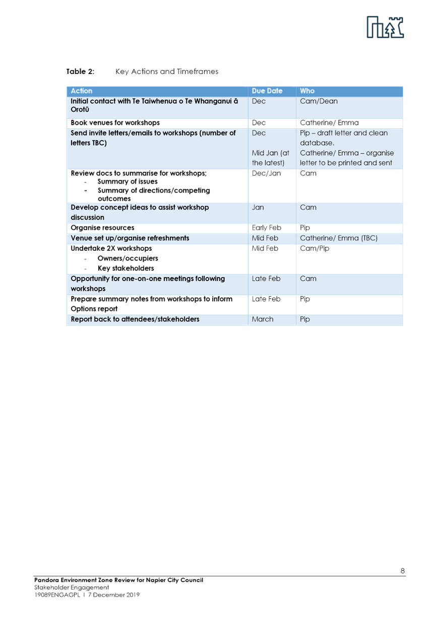
5 District Plan Review - Pandora Industrial Area Rezoning Options...... 95
6 District Plan Review - Recommended Policy Approach for Stakeholder Engagement.................................................................................... 187
7 Coastal Hazards Strategy - Update from the February Joint Committee Meeting........................................................................................... 199
8 Offsite Kiwi Facility Lease................................................................ 212
9 Landfill Levy Proposal - Interim Submission to Ministry for the Environment.................................................................................... 217
10 Indoor Sports Working Group.......................................................... 229
11 Lease of Reserve - The Scout Association of New Zealand............. 240
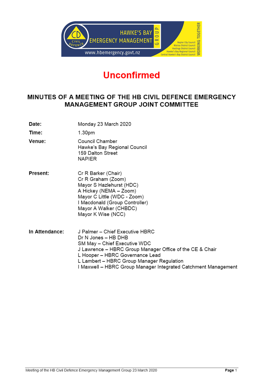
12 Civil Defence Emergency Management Group Joint Committee Draft Minutes - 23
March 2020..................................................................................... 243
Public excluded ............................................................................... 248
Extraordinary Meeting of Council - 09 April 2020 - Open Agenda Item 1
1. Whakarire Revetment - Funding Decision
|
Type of Report: |
Operational |
|
Legal Reference: |
Local Government Act 2002 |
|
Document ID: |
911279 |
|
Reporting Officer/s & Unit: |
Jon Kingsford, Director Infrastructure Services |
1.1 Purpose of Report
The purpose of this report is to:
· Update Council on recent engagement undertaken in relation to the Whakarire Avenue Revetment project
· Obtain approval to proceed with the project; and
· Confirm direction from Council on the balance on the public / private funding split for the project.
|
That Council: a. Note the change in scope of the project to now include stormwater conveyance, landscaping and third party supervision. b. Resolve to proceed with the project. c. Approve the updated project Cost Estimate that now includes additional items, including landscaping, stormwater conveyance and third party supervision and to fund the additional cost from loans. d. Approve the private contribution to be held at the same amount as per the 2019/20 consultation, resulting in a change to the public/private split to 2.5% private/ 97.5% public. e. Note that Council have committed to further consultation with residents of Whakarire Avenue to development a landscaping plan and that this will be undertaken as the project commences. |
|
That the Council resolve that the officer’s recommendation be adopted.
|
1.2 Background Summary
The Whakarire Revetment initiative has been in planning for many years and has been the subject of many discussions and reports. This report seeks to strike a balance between summarising past discussions and reports within the body of the report and appending reports to provide additional information.
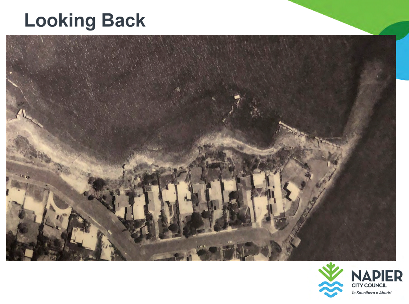
The present breakwater was constructed in 1994 and encloses a small lagoon that fills and empties with the tide. The area is frequented by families over the summer season and by surfers at any time there is sufficient swell. However the area is not as popular as other beach areas as access to the lagoon and along the reserve area in front of the houses is difficult, with private infrastructure encroaching into the reserve.
The original sea wall was constructed of concrete rubble. In 1995 approximately 15,000 cubic metres of fine gravel and sand were placed behind, and adjacent to the sea wall. In 1997 the initial works were dressed with limestone rock armour although this is mainly confined to the leeward side.
In 2003 a BECA report on coastal erosion along Westshore identified that during a significant storm with elevated sea levels it is likely the existing breakwater would fail. (Beca 2003). At that time some of the limestone rock armour has become displaced and can be seen on both the seaward and leeward sides of the existing breakwater. Further displacement of rock has occurred in the intervening years, further compromising the integrity and effectiveness of the breakwater.
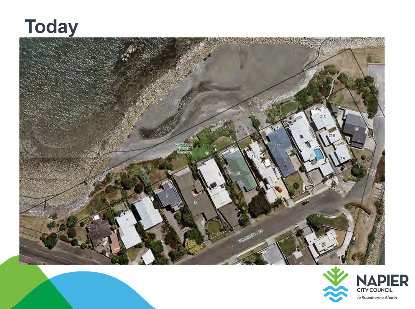
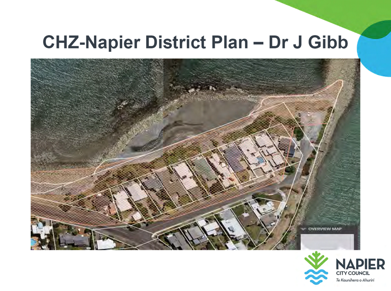
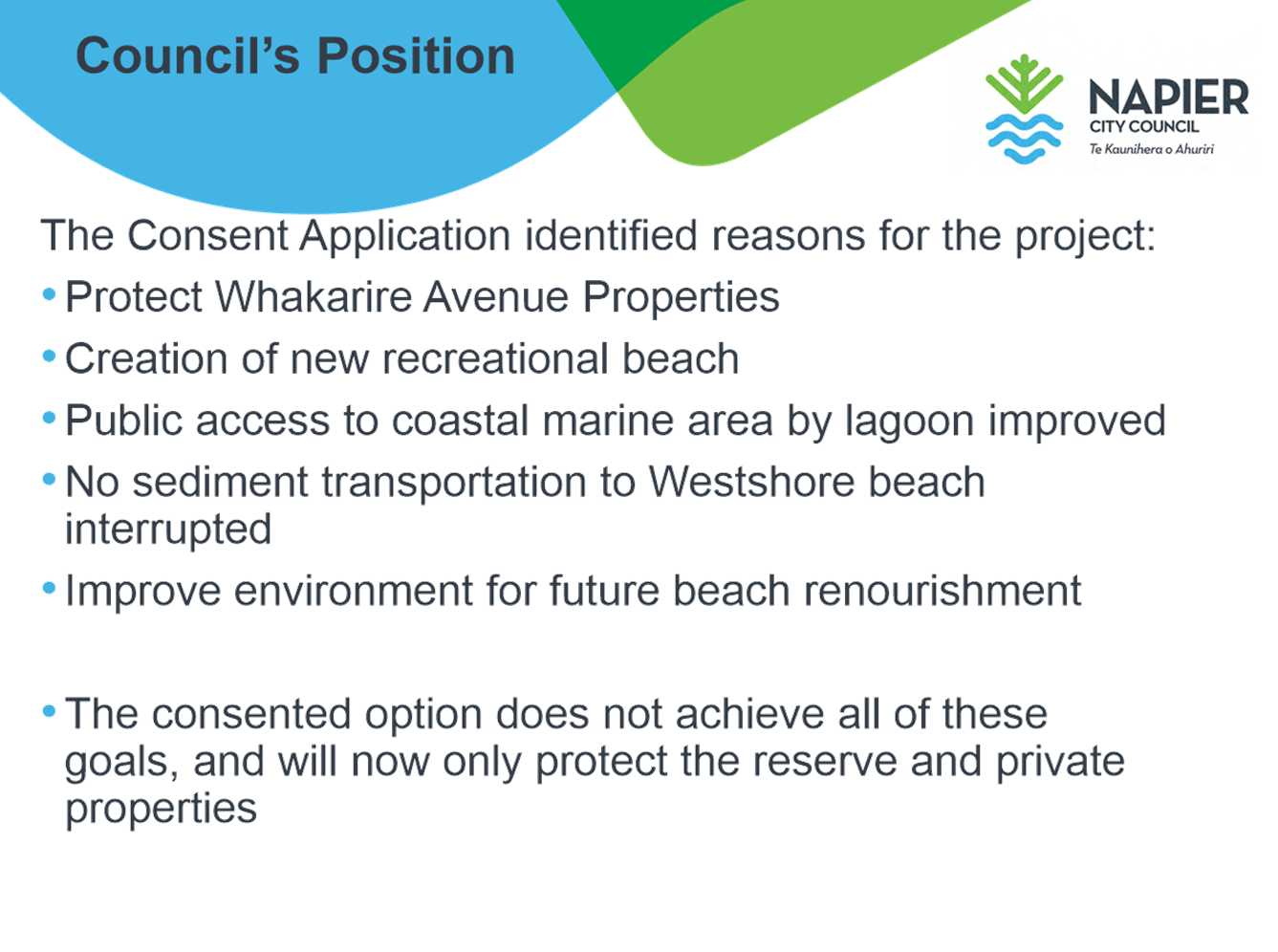
It is proposed to rebuild the existing breakwater that fronts properties in Whakarire Avenue. The existing structure also funnels waves into the southern end of Westshore Beach causing northward and seaward movement of sediment and the renourishment material placed there.
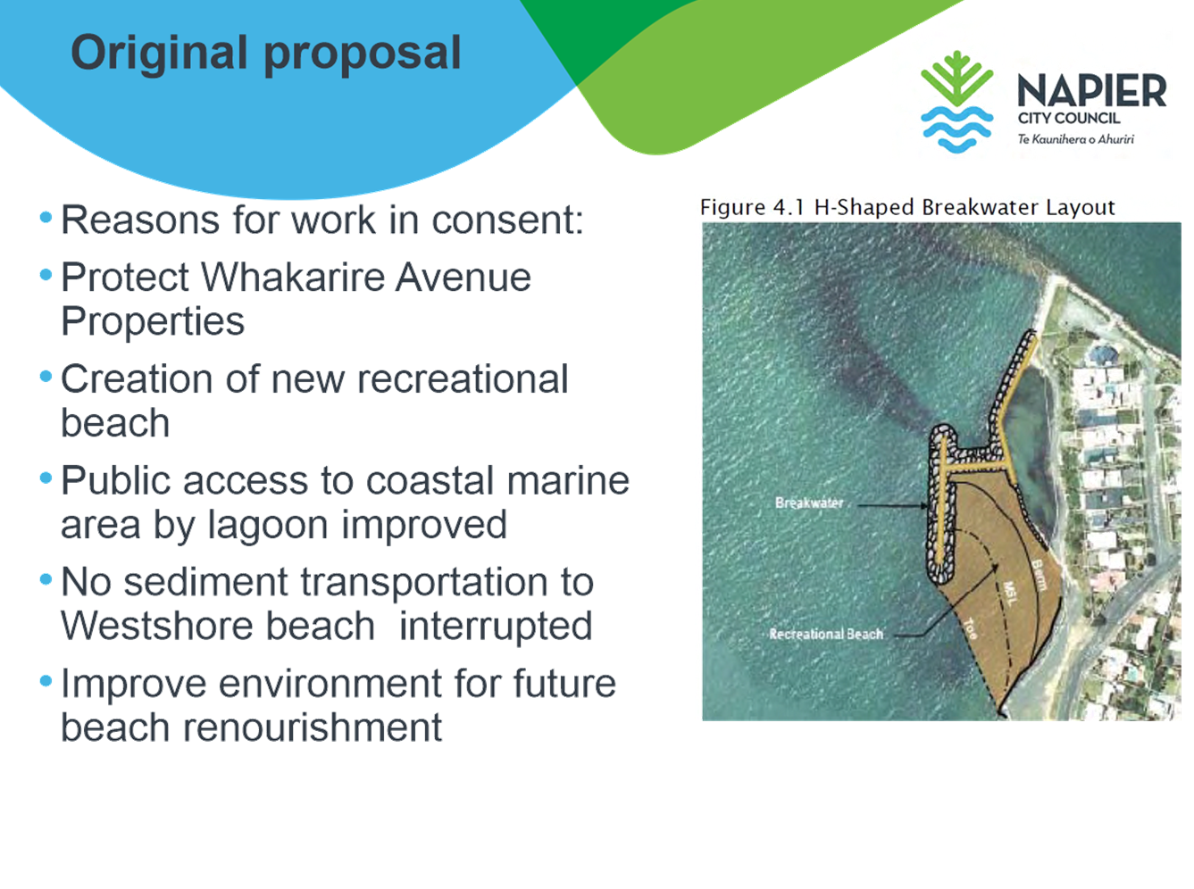
A consent application for the construction of a seawall was lodged with the Hawkes Bay Regional Council (HBRC) in 2009, for a significantly larger and more comprehensive structure than that which was finally consented.
The original design of the groynes to remediate the threat of coastal erosion in this area received significant opposition from the surfing community and local residents. As a consequence the resource consent application received many submissions in opposition. Through mediation a new design was introduced to the submitters. The new plans included a reserve area for public access and a revetment which would hug the coastline and not intrude into the surf break as the initial design had done. Residents in the Whakarire area and other submitters including the surfing community signed off on these new plans agreeing to the revetment and the reserve areas.
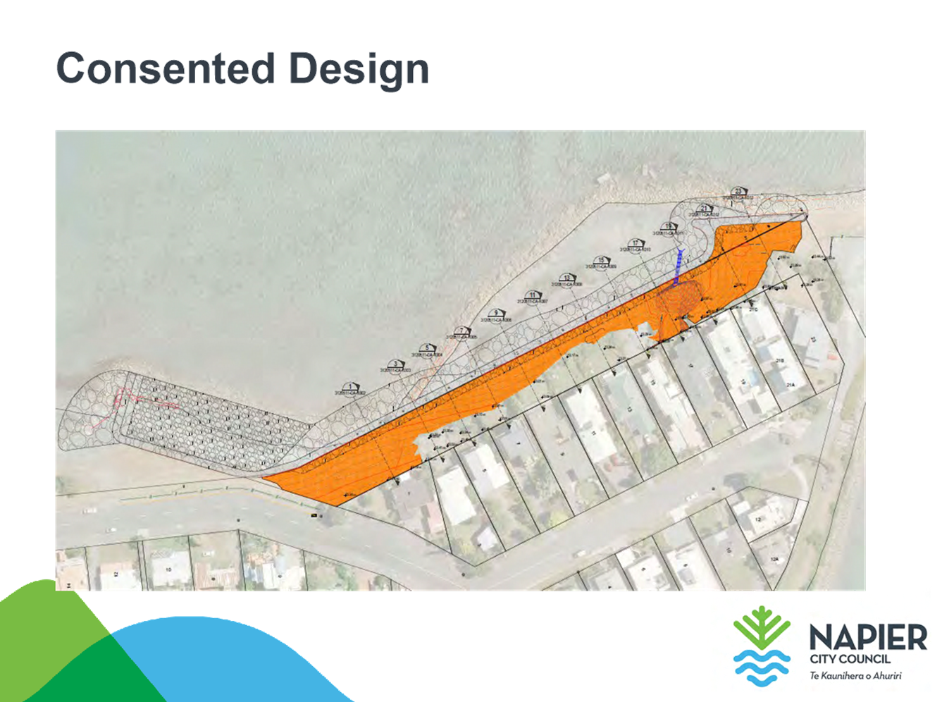
Consent was granted in October 2016 and is required to be given affect to within 5 years prior to the consent lapsing.
In order for the project to proceed, Council made available capital funding to the value of $1.737mill in the 2018-28 Long Term Plan.
While funding of the revetment had never been actively discussed with the submitters or the Whakarire Avenue residents, there was an implicit assumption at the time that the costs would be absorbed by all the city’s residents. This reflects that Napier (being a city council with relatively small rural land holdings) has not had a strong tradition of using targeted rates (N.B. current targeted rates are listed in the Long Term Plan on page 203).
Subsequent to the resource consent for the works being fully approved for construction, the regional coastal erosion work (Clifton to Tangoio Coastal Hazards Strategy) began to explore and define the beneficiaries from coastal erosion interventions to understand the link between those who benefit and those that are paying. In this way the community good and the private good is identified in particular.
Essentially this work has hypothesised that the immediate property abutting the coastal erosion will benefit significantly if work is done to halt that erosion. There is also a suggestion that there might be secondary beneficiaries, where a public space (reserve or road) lies between the property and the coastal erosion or where the local community might have added benefits of accessing the area under threat from erosion. Both of these scenarios are over and above the benefits received from doing the work by the rest of the Napier residents.
The work also identified regional and national beneficiaries. This included the Port and Airport and the region and nation as a whole. However it should be noted that these parties are difficult to realise funding from – therefore the while a percentage of benefit/ cost can be apportioned it can’t be collected using rates for example.
Council held a workshop to discuss and explore how such a funding split (as prescribed by Section 101 (3) of the Local Government Act) would apply to Whakarire revetment.
At Council’s Finance Committee on the 18 of October 2018 the basic steps associated with an assessment under Section 101 (3) LGA applied to the Whakarire revetment project were outlined.
At the Council on the 11 of December 2018 the funding split of 97% public and 3% private was approved in Principle, noting that consultation would be undertaken regarding the funding model and that residents would have the opportunity to engage in that process.
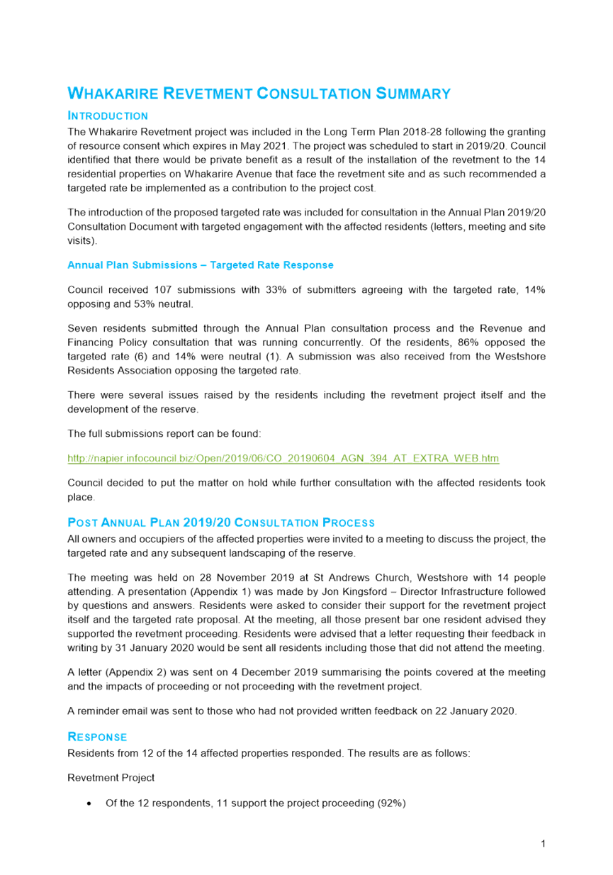
In 2019/20 Annual Plan consultation process, on a targeted rate, feedback from the general community of 107 submitters, was 14% disagreed, 33% agreed, and 53% neutral. Of Whakarire Residents, 86% disagreed, and 14% were neutral.
Since that time, Officers have undertaken further consultation with residents.
Annual Plan and post Annual Plan consultation is detailed in the Consultation report (attachment A). Post Annual plan consultation is summarised below.
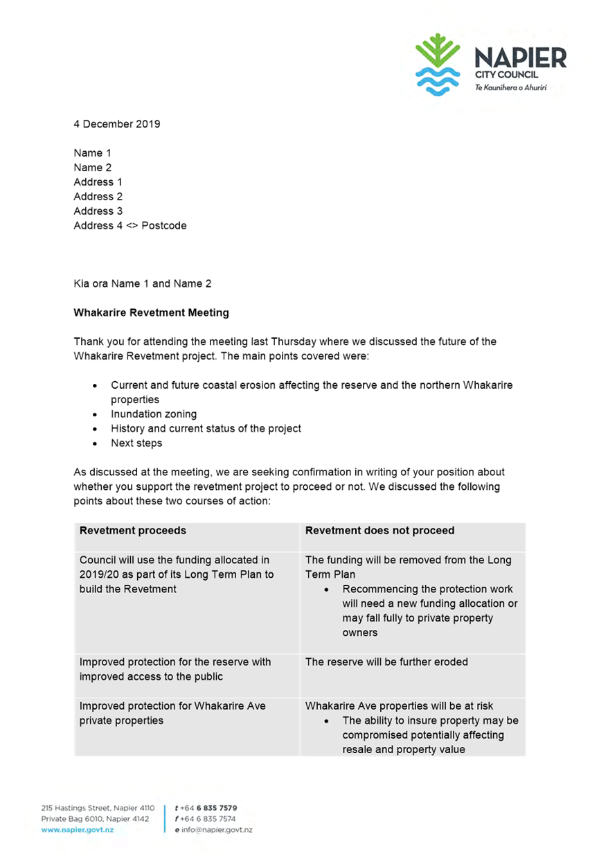
All owners and occupiers of the affected properties were invited to a meeting held on the 28th of November 2019 to discuss the project. 14 people attended the meeting which commenced with a presentation (included in the consultation report - attachment A) made by Jon Kingsford – Director Infrastructure and was followed by questions and answers.
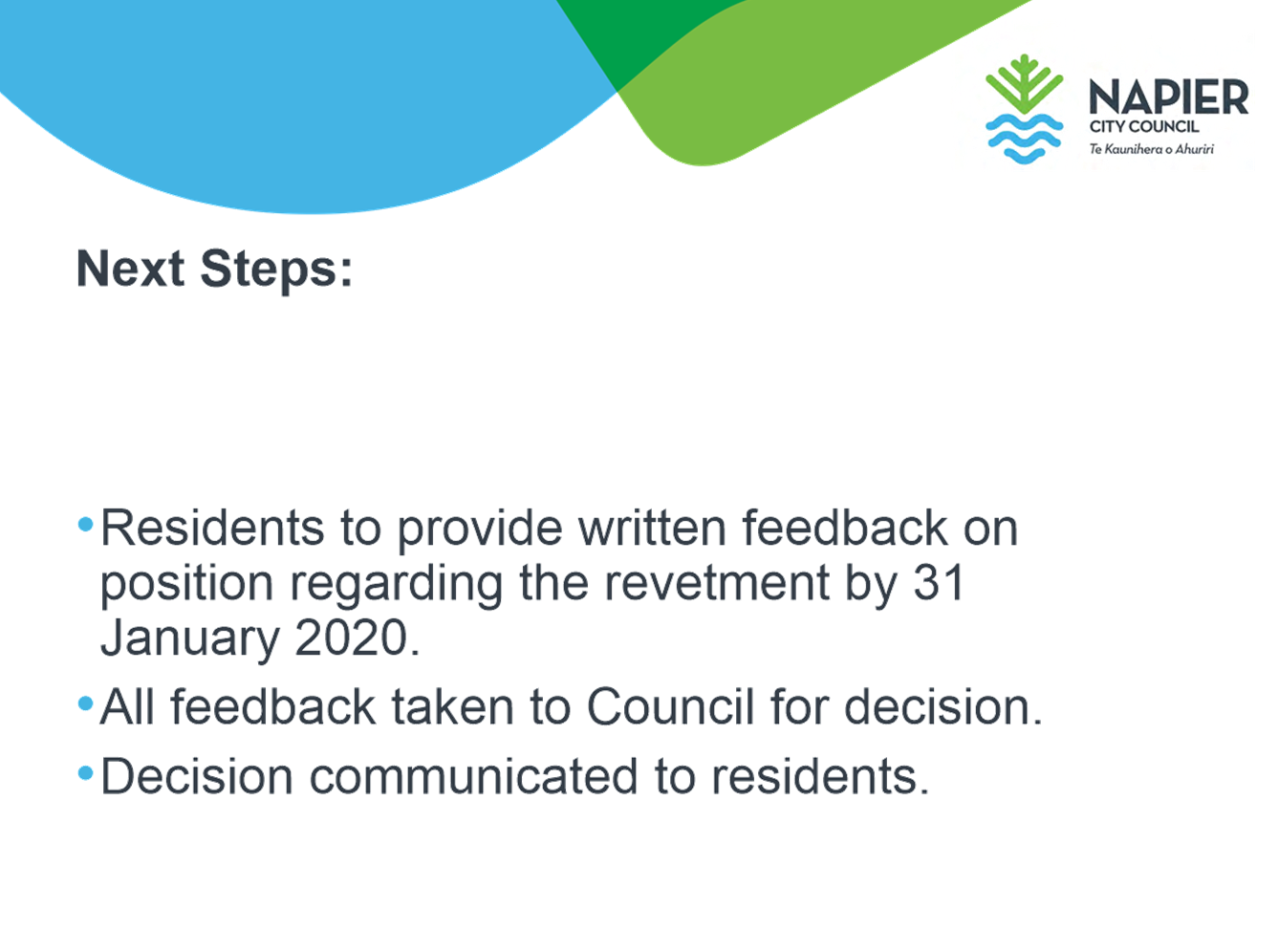
Residents were asked to consider their support for the revetment project itself and the targeted rate proposal. At the meeting, all those present bar one resident advised they supported the revetment proceeding. Residents were advised that a letter requesting their feedback in writing by 31 January 2020 would be sent all residents including those that did not attend the meeting.
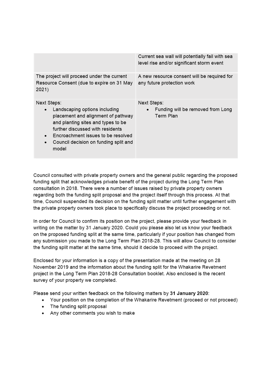
A letter (included in the consultation report - attachment A) was sent on 4 December summarising the points covered at the meeting and the impacts of proceeding or not proceeding with the revetment project.
A reminder email was sent to those who had not provided written feedback on 22 January 2020.
Residents from 12 of the 14 affected properties responded. The results are as follows:
Revetment Project
· Of the 12 respondents, 11 support the project proceeding (92%)
· Of the residents, 11 support the project proceeding, one is against the project proceeding and two did not respond. A total of 79% of residents support the revetment proceeding.
Targeted Rate
· Of the 12 respondents, seven agree with the targeted rate (58%), four were against (33%) and one response was inconclusive.
· Of the residents, with seven agreeing, four against, one inconclusive and two with no response, a total of 50% of residents agree to the targeted rate.
Detail on submissions and responses is available in the consultation report attached.
1.3 Issues
Following several engagement efforts with residents there is now clear majority support for the revetment project proceeding; however, there does not appear to be clear support for the targeted rate.
All consultation to date has been based on the project cost budgeted for in the 2018-28 Long Term Plan of $1.747mill. The current project estimate, accounting for some changes in scope now place the project cost at $2.2mill.
Of those that were willing to pay a targeted rate, several residents preferred to pay the full amount in a one-off payment and that the contribution be based on the $1.747 million originally proposed as the project cost.
1.4 Significance and Engagement
Approval of a funding option will require further consultation through the 2020/21 Annual Plan. This matter has been incorporated into the recent report to Council on draft annual plan consultation items and is further discussed below.
1.5 Implications
Financial
Council Officers have reviewed the timing of the project and project costs, with revised costs of an estimated $2.2 million.
The increased costs are partly due to expected increases in material costs, however the estimate now also includes items that amount to a change in scope to include stormwater management and landscaping (originally to come post project completion), and also recognises project and contract management costs, fees for the independent Chartered Engineering supervision of the construction and a contingency sum of $200,000 + GST.
Social & Policy
N/A
Risk
One resident has responded to Council’s engagement process through their barrister. This resident has voiced strong opposition to the project and to the proposal of a targeted rate. There is a risk that this resident will choose to further litigate this matter with Council should the decision be made to proceed with the project and/or the targeted rate.
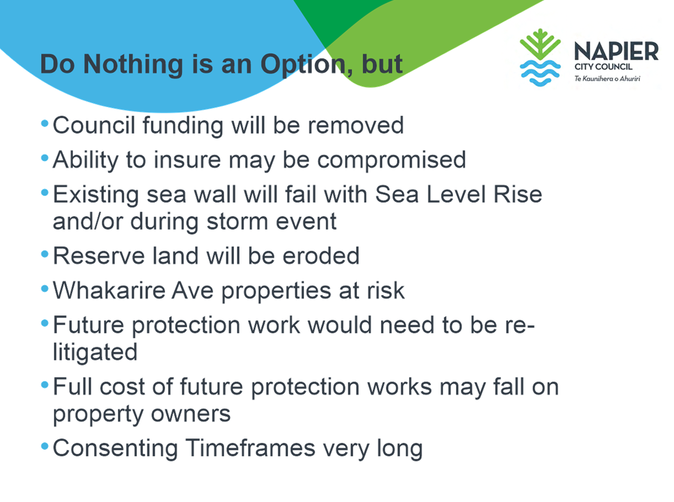
Council do have the choice of not proceeding with the project. Such a decision would recognise that the reserve then performs the role of a buffer to erosion of private property and will eventually be lost. Should the project not proceed the risk of coastal erosion resides with individual property owners. At this point Council may need to reassess whether protection of Charles Street is required and how it might be provided.
1.6 Options
The options available to Council are as follows:
a. Not proceed with the project.
b. Proceed with the project and rescind the resolution to seek a private contribution to the cost of construction, thereby choosing to fund the project from public funding only.
c. Proceed with the project and proceed with the original 3% private contribution to the current construction estimate of $2.2mill.
d. Proceed with the project and resolve to adjust the private contribution to 2.5% of the current construction estimate $2.2mill.
1.7 Development of Preferred Option
Council have invested a significant level of time and resources into the process to obtain the resource consent for the proposed revetment works. The consent process spanned a period of over 5 years and went to mediation in order to avoid the environment court.
While Council Officers are neutral as to whether the project proceeds or not, on principle to not realise this level of investment would be disappointing.
It would be very difficult for individual property owners, or a group of property owners to navigate the consent process should Council choose not proceed with the project.
A lot of time and effort has been invested engaging with property owners of Whakarire Avenue to provide further information on the project, understand their concerns and with regard to stormwater adapt the project to reach a better solution for residents. During this time, the discussion on the mooted 3% private share of a project cost of $1.747mill. to now apply that 3% private share to the updated project cost ($2.2mill) would likely result in a withdrawal of residents support for the project
The preferred option is therefore to proceed with the project and resolve to adjust the private contribution to 2.5% of the current construction estimate $2.2mill.
a Attachment A - Consultation Summary Report ⇩
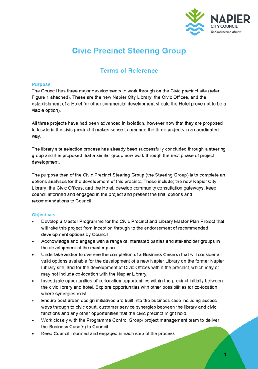
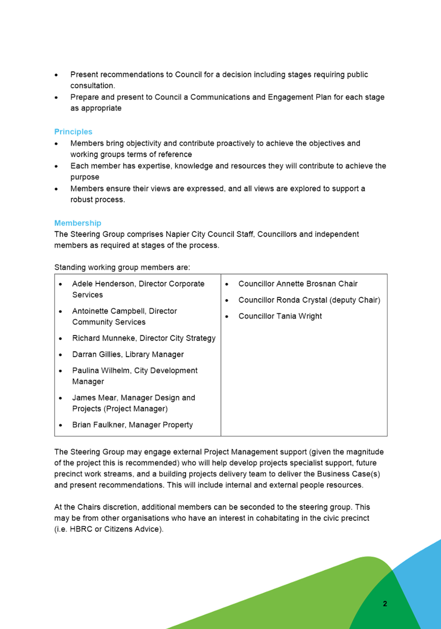
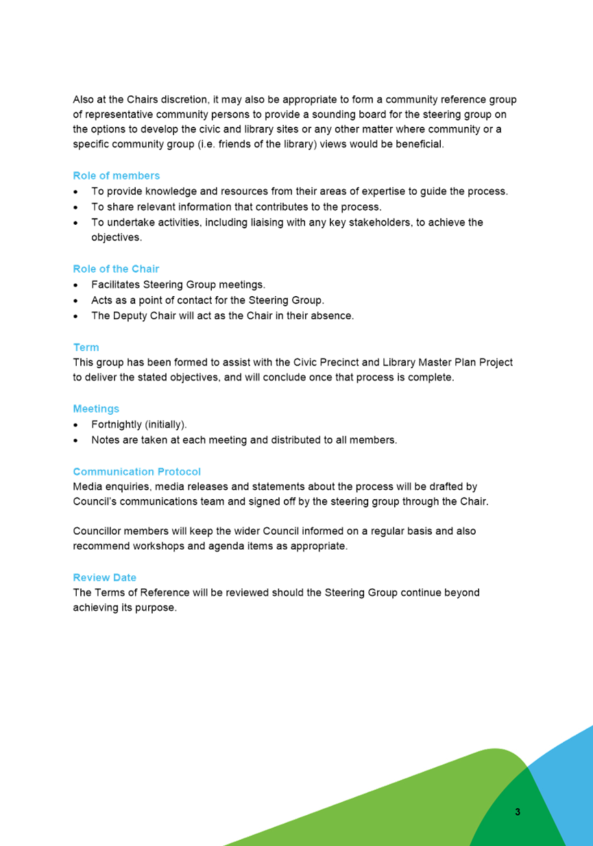
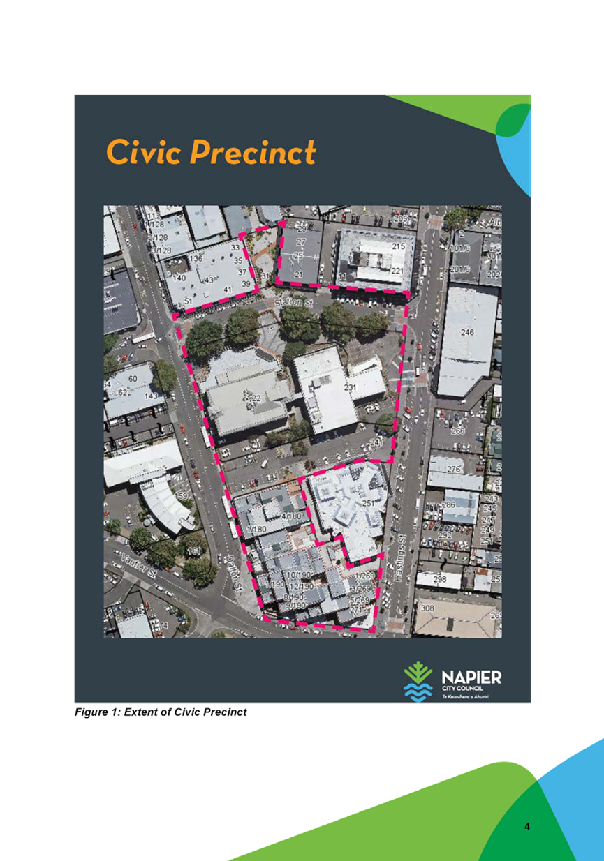
2. Civic Precinct Project Steering Group
|
Type of Report: |
Procedural |
|
Legal Reference: |
N/A |
|
Document ID: |
908302 |
|
Reporting Officer/s & Unit: |
Richard Munneke, Director City Strategy |
2.1 Purpose of Report
The purpose of the report is to update Council on the process, recommendations and decisions made to date on the Council Civic offices, Hotel development, and new Napier Library. The report also seeks endorsement for the formation of a Steering Group to support the project’s next steps through the development of a civic precinct masterplan.
|
That Council: a. Receive and accept in principle the recommendation from the Library site project steering group to pursue the development of the library on the Station Street site. b. Endorse the formation of a Civic Precinct Steering Group. c. Endorse the Civic Precinct Steering Group Terms of Reference. d. Note that the Civic Precinct Steering Group will undertake comprehensive master planning for the Civic Precinct including any important linkages beyond that site, keeping Council informed ahead of specific recommendations to Council on the master planning. e. Note that the Civic Precinct Steering Group will recommend key consultation steps to Council for the project f. Note the annual plan will include the preferred site for the library, and that any feedback on this through the annual plan can be forwarded to the Civic Precinct Steering Group for consideration in the master plan development g. Resolve that the time capsule and mural relating to the civic building be housed in temporary storage prior to demolition of the old civic site. |
|
That the Council resolve that the officer’s recommendation be adopted. |
2.2 Background Summary
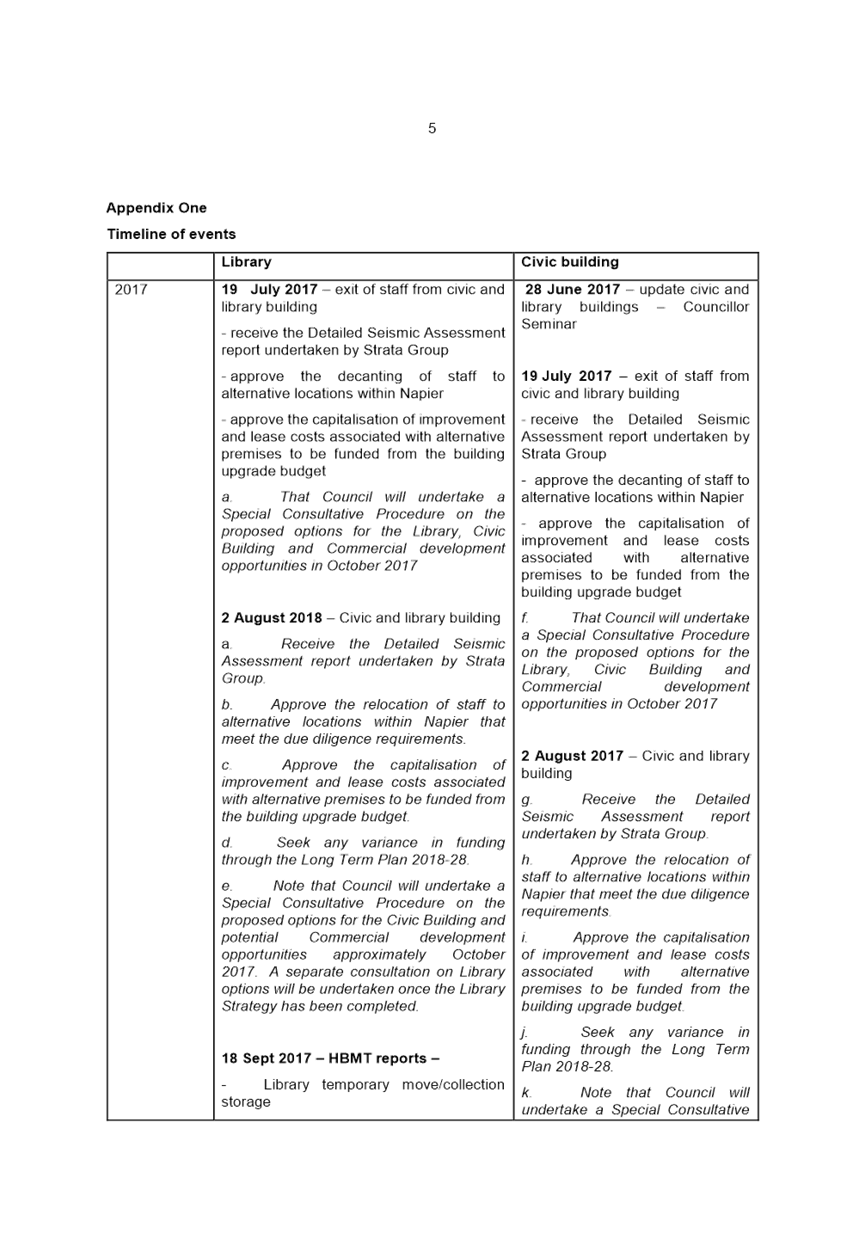
The 2015-25 Long Term Plan allocated $7.5m to fix seismic issues and refurbish the two civic buildings. Following the Kaikoura Earthquake of 2016, the Building (Earthquake-Prone Buildings) Amendment Act 2016 amended the method of assessing buildings for their seismic strength and how they were to be rated. In mid-2017 Council engaged structural engineering specialists to undertake a new seismic assessment of both the Library and Civic Buildings under the new Building Act requirements. The results of this assessment found that the Library Building achieved 15% NBS (new building standard), while the Civic Building achieved 10% NBS, making both buildings earthquake-prone.
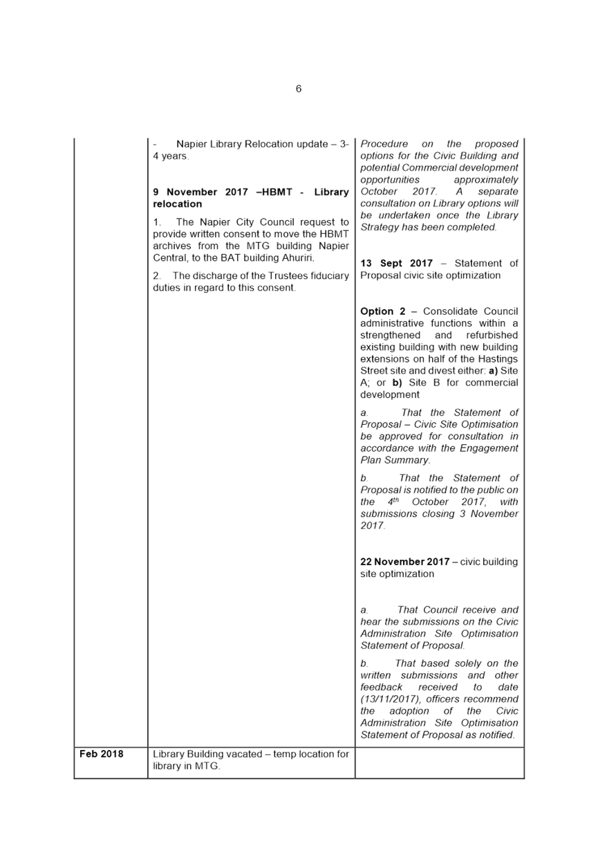
In September 2017, the Napier Library relocated to its temporary premises at the MTG. Cost estimates to strengthen and refurbish both buildings were deemed unfeasible. Council offices were also decanted to the three buildings in which they are located presently.
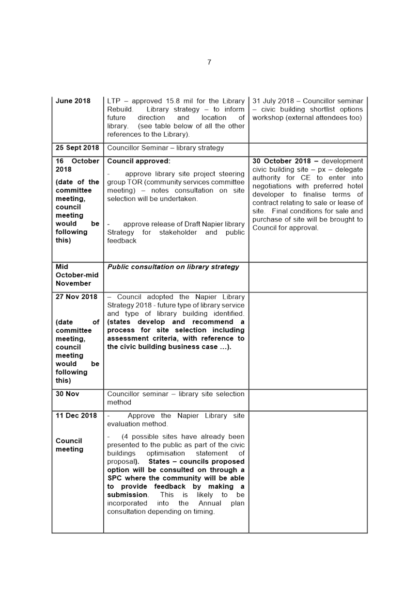
In December 2017, a Statement of Proposal (SOP) to divest the site on which the Civic Building is located was approved by Council. The SOP was supported by a Business Case that showed how both the Council offices and a central Library could be accommodated within the Library Building site. Additionally, it considered which type of commercial development would provide the greatest benefit to the City, recommending that a 4+ star international-brand hotel was a viable prospect that could provide the greatest benefit to the City.
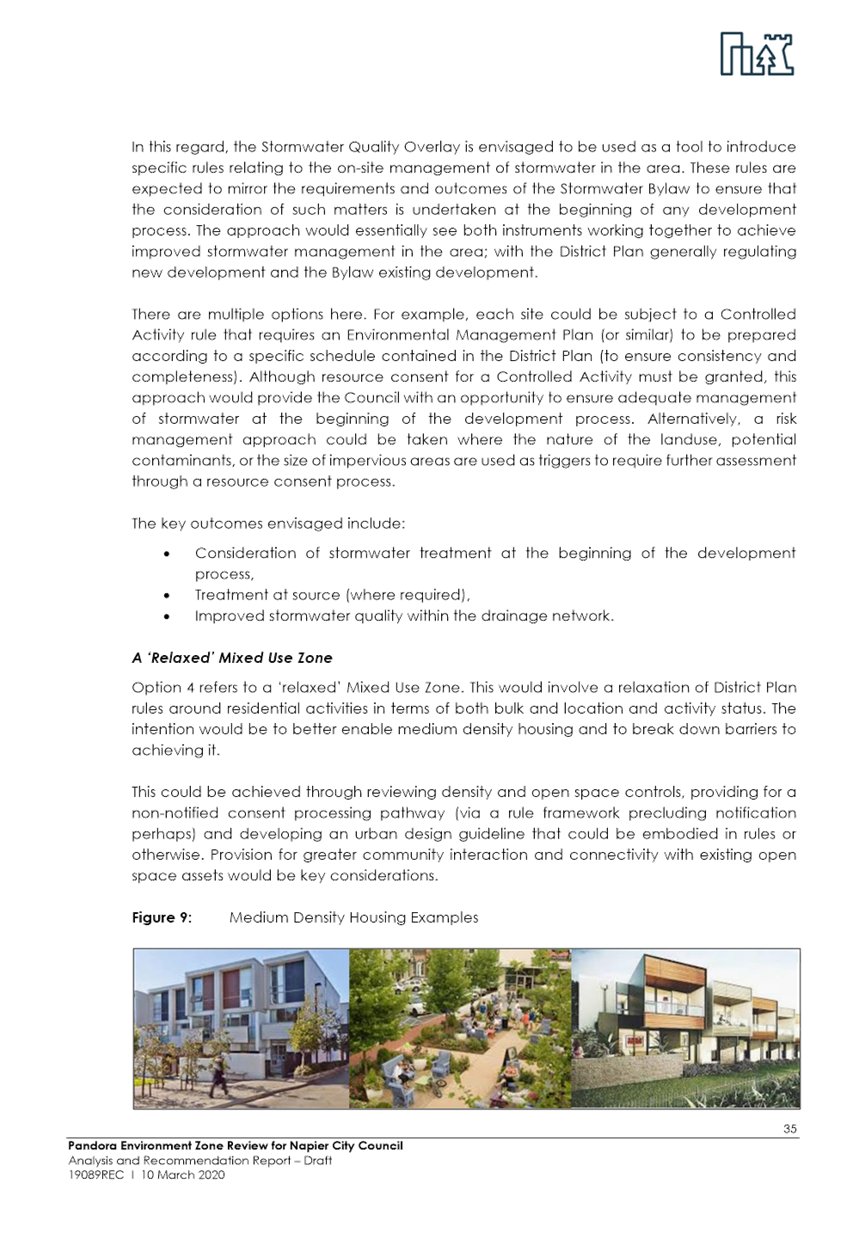
Hotel-Mixed Use Development
Following an early Expression of Interest (EOI) process, a Request for Proposal (RFP) was sent to several hotel operators. Candidates were assessed against a number of criteria including proven performance, financial backing, job creation, and environmental credentials. Council began negotiations with the winning candidate, Estilo, in 2018. This development would see a mixed-use development, with ground-floor retail, all day dining facilities, roof-top bar and a 4.5-star hotel of 128 rooms. The building would be of modular construction achieving a 5-star Green Star rating.
Modular construction, where the building is constructed using a series of modules built off-shore and assembled on-site, is a fairly new building technique in New Zealand, and does not have a standardised and well-tested method for ensuring construction meets New Zealand Building Code requirements. This presents a risk to Council in relation to liability. Council are currently working through ways to reduce this risk with the Ministry of Building, Innovation and Enterprise (MBIE).
While negotiations continue, Council Officers will continue working with MBIE and will demolish the Civic Building, making the site ready for redevelopment.
In terms of demolition two matters require resolution that being the time capsule and the mural on the east wall. It is envisaged that these be removed to temporary storage so that they do not hold up the demolition programme in the meantime. From there each item’s permanent home can form a project in its own right.
Library
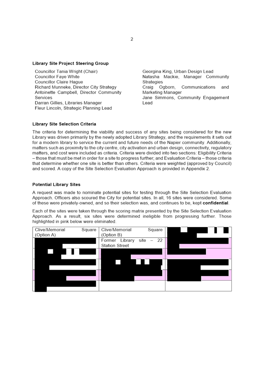
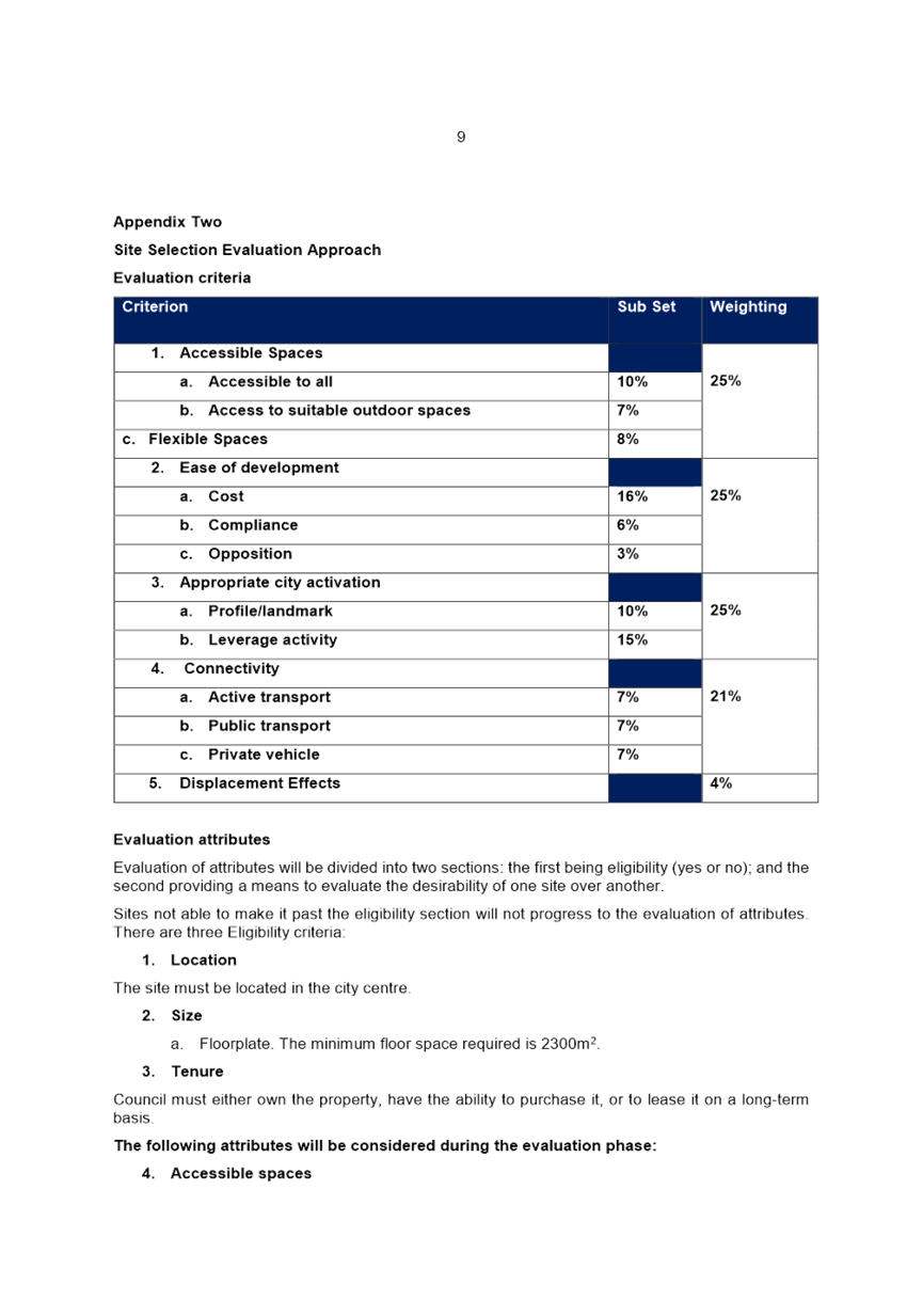
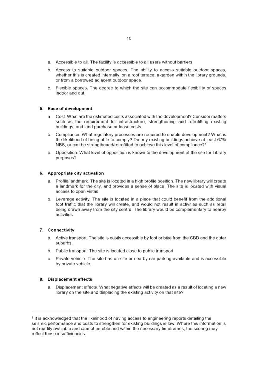
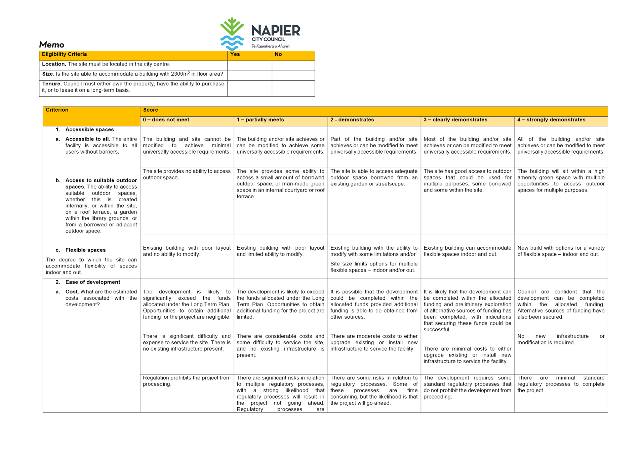
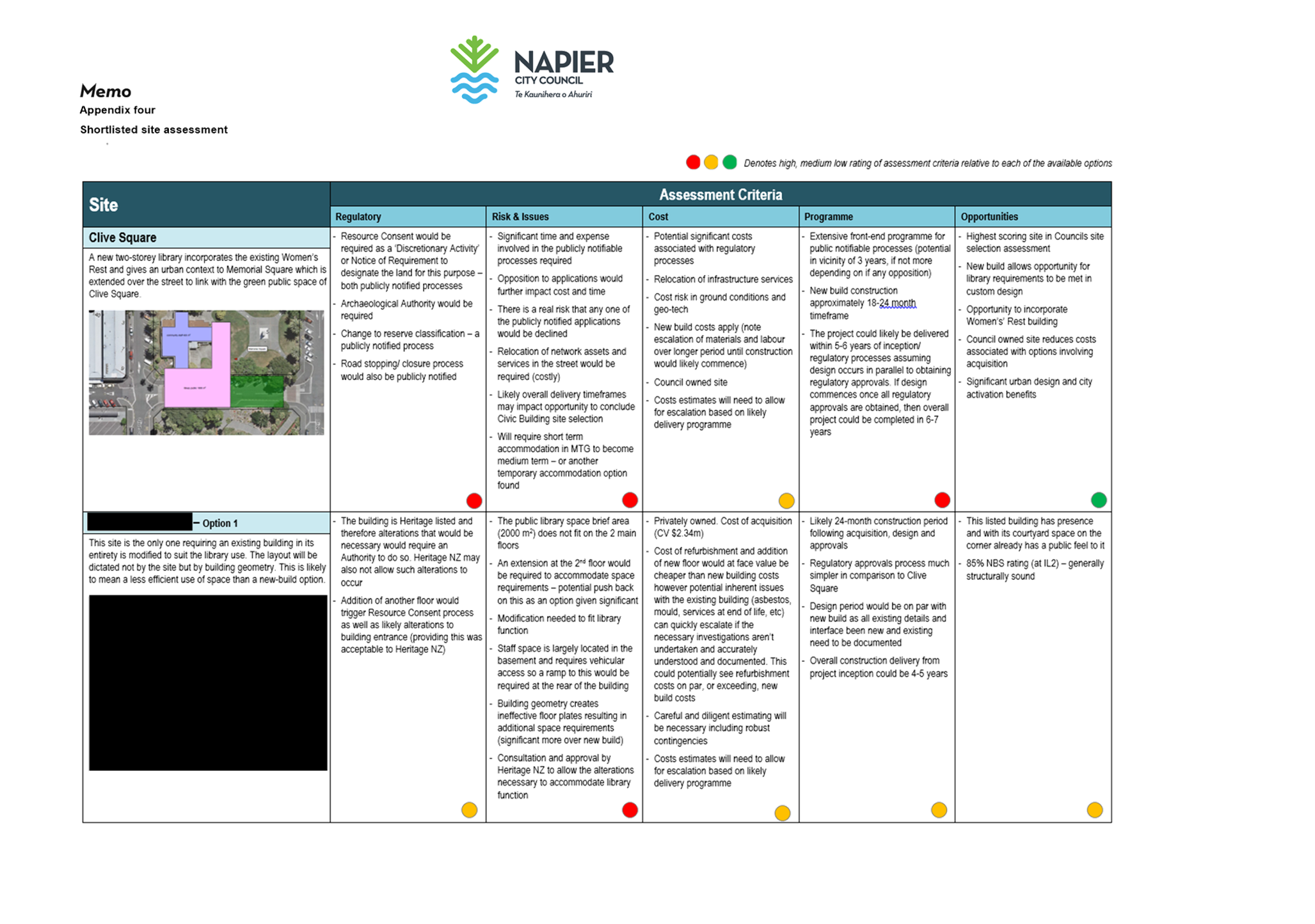
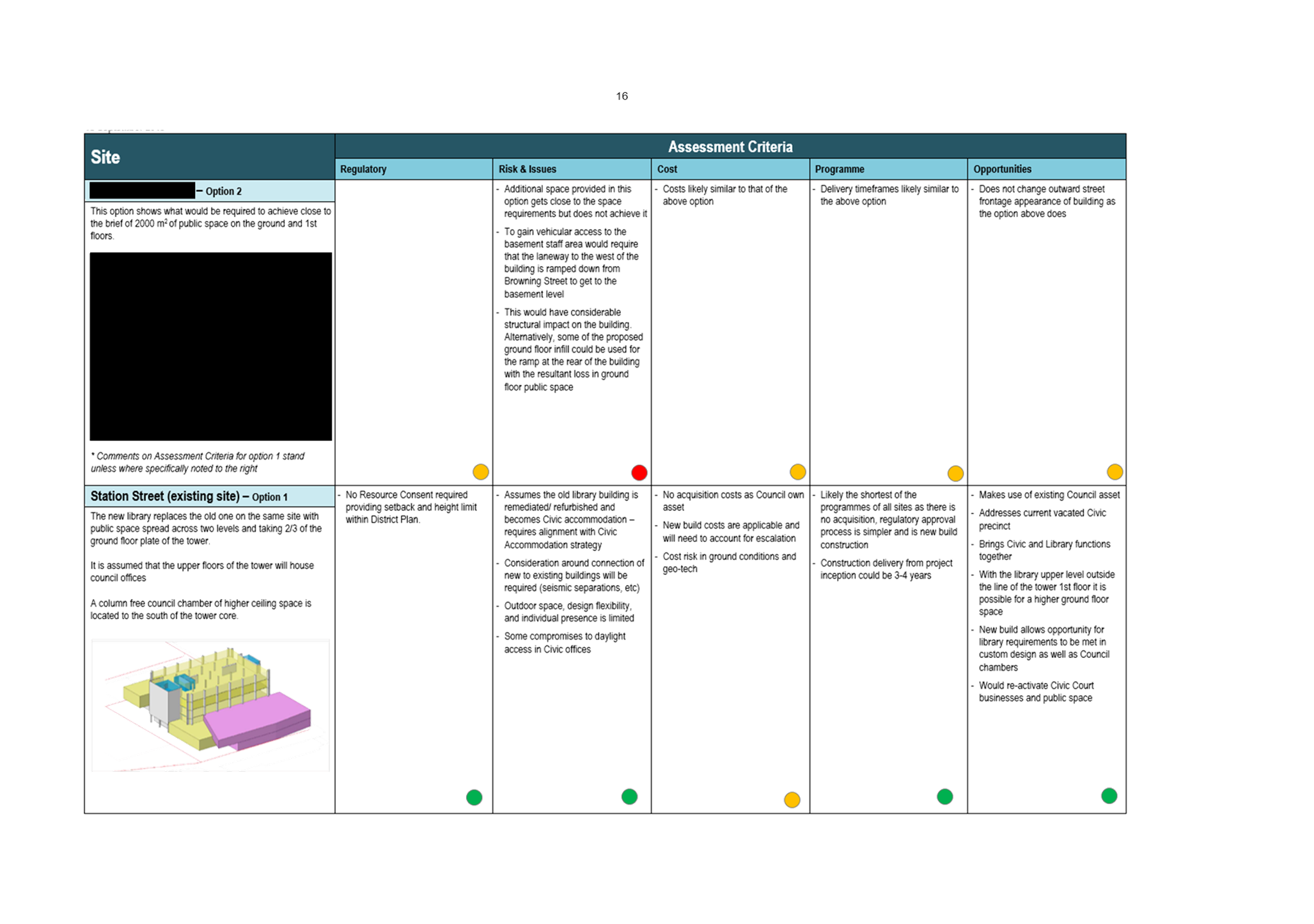
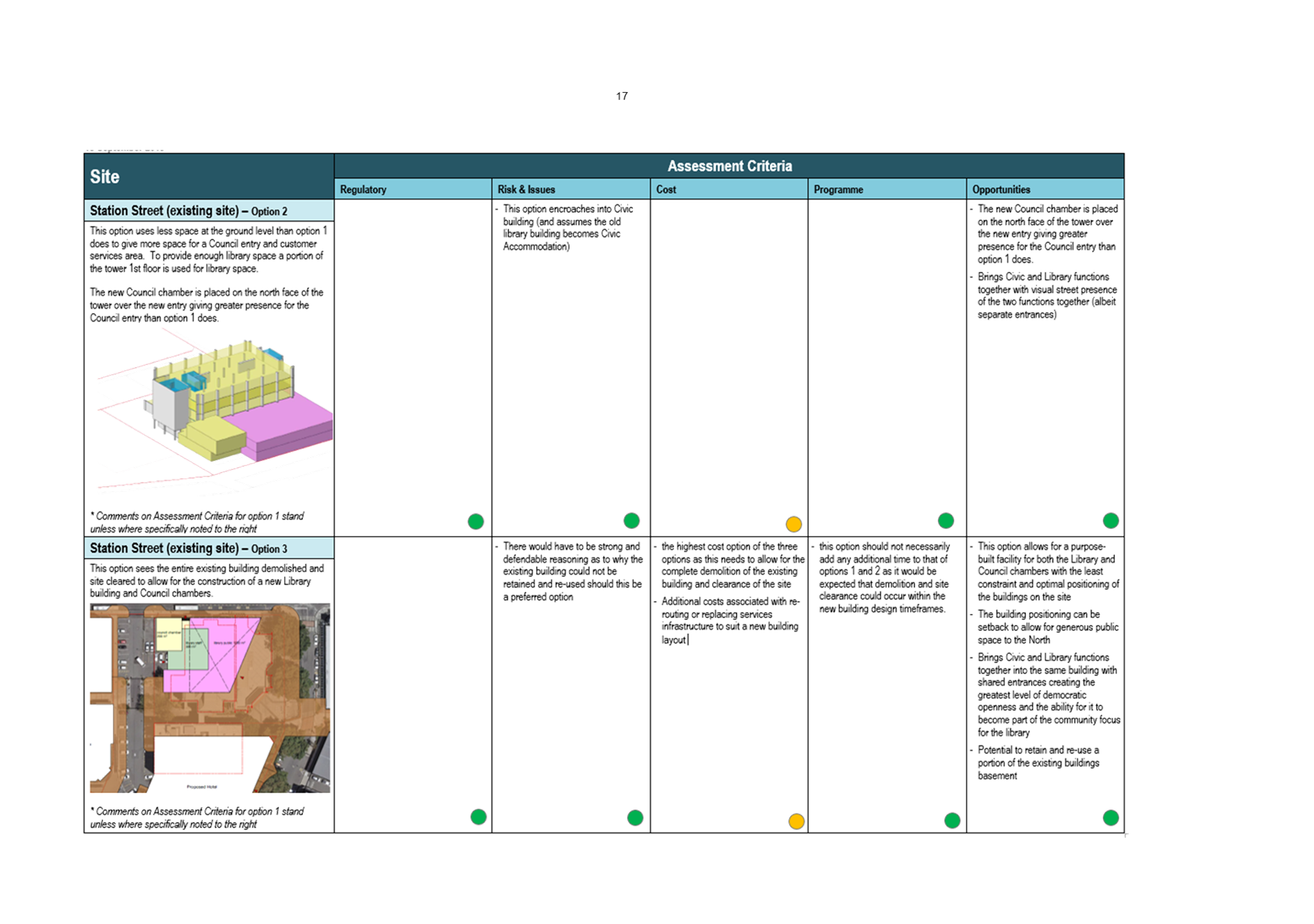
In 2018, Council adopted the Library Strategy, which established the community’s needs for Napier’s new Library, and helped define the criteria for a suitable Library site. Requirements included a minimum of 2000sqm public space over a maximum of two levels, access to the outdoors, a sense of place, accessible and adaptable spaces, and a good neighbour and landlord to likeminded collaborators.
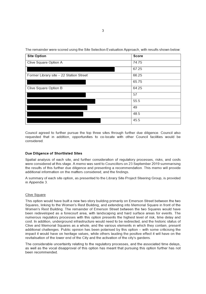
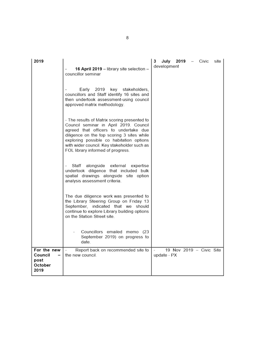
Using this information, Council Officers devised a multi-criteria analysis that, once approved by Council, was used to assess the 16 Napier CBD sites that had been suggested. A steering group comprising of elected members and Council officers considered the all the sites against the selection criteria. Three sites were short-listed, including one privately-owned site and two publicly-owned sites. One of these was the site of the former Napier Library, at 22 Station Street, while the other was a site formed by taking sections of road, and a small portion of Memorial Square, connecting to a refurbished Women’s Rest. Further due diligence on all three sites discounted both the privately-owned site and the Memorial/Clive Square site, leaving the recommended site of Station Street, the home of the former Napier Library. The site selection process together with the findings of the steering group can be found at attachment?
This paper seeks endorsement from the Council to accept the site selection process in principal and indicate that Council efforts now focus on master planning the library with the civic function and the hotel development in what is termed at this stage the civic precinct.
Council will signal to the public its’ desire to return the library function to its original site through this years’ annual planning process and request feedback. Comprehensive public engagement including a full statement of proposal can then occur on the masterplan for the entire site.
Civic Offices
Following the Council decision declaring the Civic Building surplus to Council requirements, Council engaged consultants PWC to prepare a Business Case on the options for the new Council Offices. A long list of options was considered including, but not limited to the reuse of the old Library Tower building; the demolition of the library Tower building and rebuild of a new building on this site; continued leasing of the existing buildings, and the purchase and fit out of another building. In assessing these options, it was important that a number of outcomes could be achieved, including:
· Optimising the footprint/cost per person
· Customer experience
· An accessible Chambers/place for democracy
· Optimised workplace quality
· Improved Councillor facilities
· Alignment with City Vision principles
· Financially acceptable
The recommendation made in the Business Case was to strengthen and refurbish the former Library Tower Building for Council Offices. This recommendation was however, made in isolation of the site selection process for the Library, and it is now necessary to bring all three of the above projects together to ensure the right decisions are made for the City. One of the options that was considered in the Business Case was to purchase and fit out another building. The Dalton/Vautier House Building located to the south of the Library Building is currently on the market and given its size, location and vacancy, is worth considering to further strengthen this Civic campus.
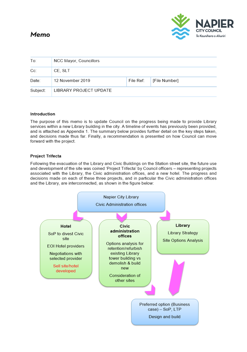
Project Trifecta
A Civic Campus at Station Street, including the Hotel on the Hastings Street edge, would anchor the southern extent of the City and bring greater vibrancy and foot traffic to this area. It would present an opportunity to reimagine Station Street as a pedestrian-centred street and a revitalised Civic Court.
Some funding has already been provided for in the Long Term Plan for each of these projects, though it is expected that these will be revised as decisions are advanced and design finalised. Sufficient funding is available in this financial year for the demolition of the Civic Building. The Library has $15.8m allocated, of which the majority sits in the 21/22 financial year. The Civic Offices have primarily OPEX funding available until such time decisions are made on the future direction of these.
To take this project forward, it is recommended that a steering group be formed to guide Council Officers in procedural matters as they relate to Project Trifecta. The makeup, responsibilities and Terms of Reference for this Working Party will be presented to Council for endorsement in the new year.
2.3 Issues
This report provides an update to Council on progress thus far of the three projects that comprise Project Trifecta, and presents a recommendation to form a project steering group to take this project through its future steps and address the myriad of issues that such a development will likely encounter.
Given the scale of the project it is essential that comprehensive master planning is undertaken for the site to ensure that the opportunities of the three developments and possibly others are realised and also that the community can engage with an overall plan in the first instance rather than individual component parts. The Masterplan development will require input from various sectors of the community and we recommend that it be appropriately resourced and advised by external providers well versed in civic projects of this magnitude. In this way the steering group will receive best practice advice from the outset.
2.4 Significance and Engagement
N/A
2.5 Implications
Financial
There is funding required for master planning, which can be accommodated within existing budgets in the first instance. There are no further financial implications at this stage, however any implications identified will be reported to Council as decisions are made and detailed design is finalised.
Social & Policy
N/A
Risk
This report provides an update to Council on the process to date, and recommends an approach for the project as it progresses to the next phase.
The main risk at this stage is that Council pursues individual projects without master planning first and a secondary risk is that insufficient resources are allocated to procuring and appropriately skilled external provider to undertake the master planning exercise.
2.6 Options
N/A
2.7 Development of Preferred Option
Steering groups that guide the direction of a project are best practice and commonplace within the industry. A Steering Group was established for the Napier Library project, which proved to be an invaluable tool for ensuring transparency and a representative voice from the community through the representation of Councillors.
This is a complex challenging city changing project of a scale that requires careful consideration of the issues and opportunities. A steering group can provide the relevant focus required across the wide-ranging issues that will be encountered and provide recommendations to the Council on a way forward.
a Civic Precinct Steering Group - Terms of Reference ⇩
b Library Project Update Memo to Council, 12 November 2019 ⇩
Extraordinary Meeting of Council - 09 April 2020 - Open Agenda Item 3
3. Marewa Shopping Centre - Transport Safety Improvements
|
Type of Report: |
Operational |
|
Legal Reference: |
Traffic Regulations |
|
Document ID: |
909468 |
|
Reporting Officer/s & Unit: |
Robin Malley, Team Leader Transportation |
3.1 Purpose of Report
To inform Council of the process followed and progress towards a design for the Marewa Shops Safety Improvement project.
|
That Council: a. Note the intent of the project is to improve safety for road users, particularly vulnerable road users. b. Note that further engagement is planned, particularly a more targeted engagement with stakeholders to ensure that construction has a minimal impact on the vibrancy of the area. c. Note that a communications and engagement strategy will be developed following approval of proposed changes. d. Approve the proposed changes to the Kennedy Road/Douglas McLean Avenue and Kennedy Road/Nuffield Avenue/Wilding Avenue intersections and separation of the Marewa Shops parking lane. |
|
That Council resolve that the officer’s recommendation be adopted. |
3.2 Background Summary
The section of Kennedy Road between and including its intersections with Nuffield Avenue and Douglas McLean Avenue, serving the Marewa shops has a high crash history with a number of serious crashes over the last 10 years. Improving the safety on this section of road is therefore a high priority for Council. The intent is to provide separation between those travelling through and those accessing the shopping centre and provide clearer routes and access points for pedestrians, cyclists and motor vehicles.
Due to the high traffic volumes it can be difficult for vehicles entering and exiting the parking area which results in queuing on Kennedy Road and within the parking area. The current angle parking adjacent to the shops results in vehicles reversing in to live traffic and also on to the on road cycle lane. This poor driver behaviour results in manoeuvring conflicts and given the proximity of the on road cycle lane it is a hazardous area for vulnerable road users. In addition to this; the uncertainty this creates can result in nose to tail crashes many of which can go unreported to the Police and therefore are not reflected in crash statistics.
The lack of separation for cyclists is a significant safety concern and seen as a barrier to cyclists using Kennedy Road which is an important link to and from the city.
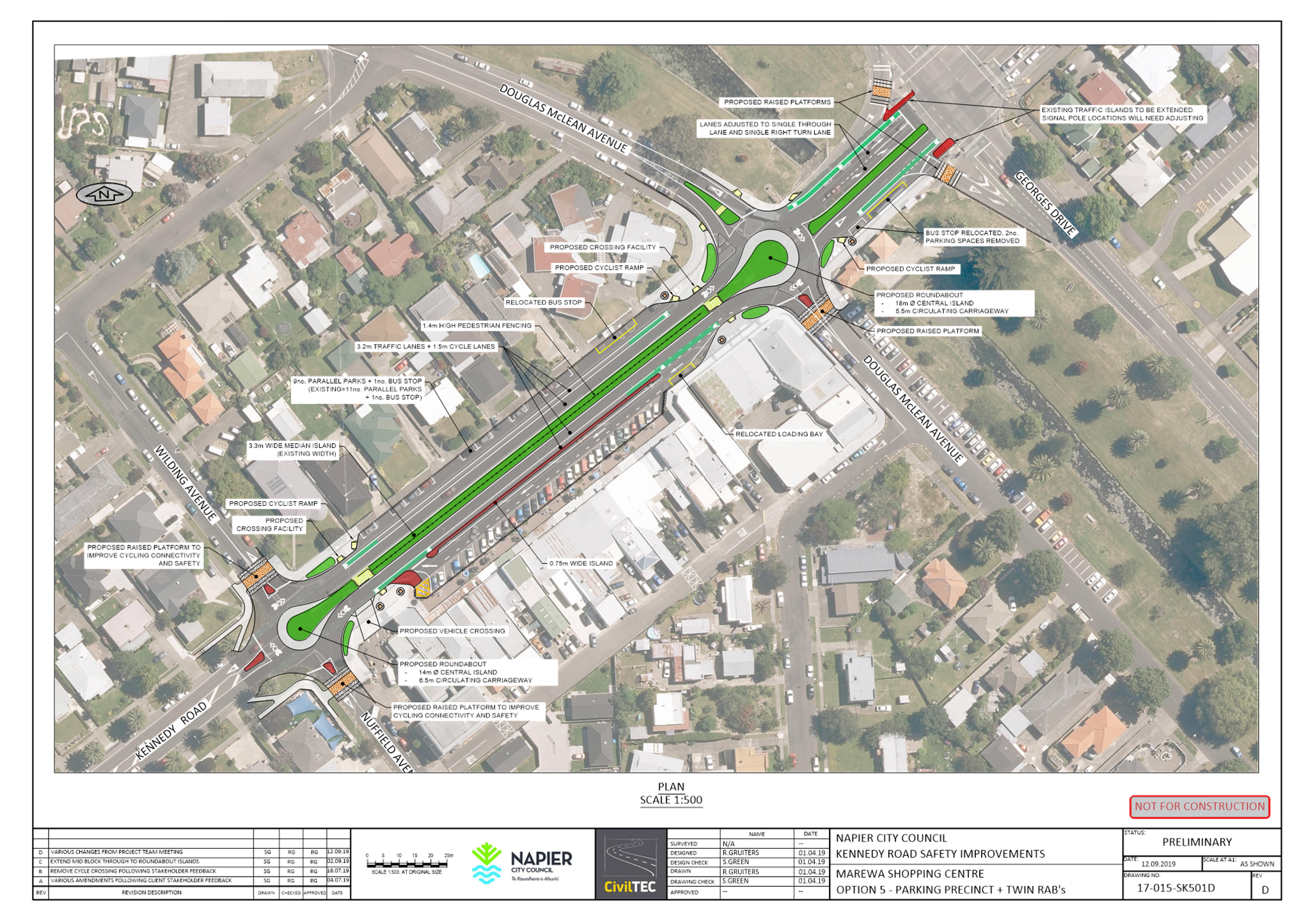
Pedestrians wishing to cross Kennedy Road are faced with 6.5m of carriageway on the northern side of Kennedy Road which includes the cycle lane and the through traffic lane. On the southern side this distance is 7.5m and includes the through traffic lane, cycle lane and flush median. The flush median on the southern side is used for vehicles wanting to enter/exit the parking area which can mean that there are multiple lanes of traffic travelling at different speeds, often concentrating on different objectives. An example of this is shown on the below extract from Google Maps Street View.
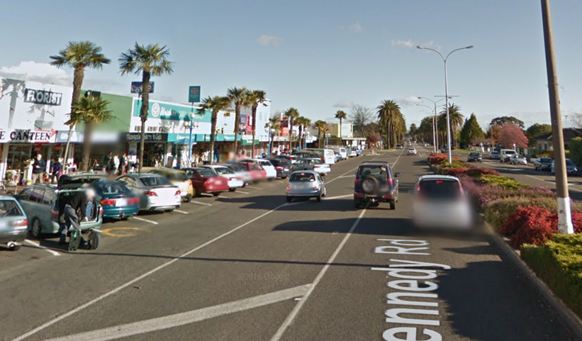
Figure 1 - Example of informal lane use (Google Maps 2012)
There have been 92 crashes on this section of Kennedy Road since 2006 which includes 3 serious and 14 minor crashes. 54% of all crashes were rear end type crashes which can be attributed to the congested parking and manoeuvring arrangement. 28% of all crashes were crossing or turning type crashes predominantly at the intersections.
The project seeks to reduce the risk of crashes and provide a safer road environment for all road users. Due to the complexity of the problem and a number of design ‘red lines’ (retention of parking, accessibility for vulnerable users, no loss of footpath space), the development of proposals has been an iterative process, with most concepts being shared with the community through street meetings, letter drops, displays and meetings.
A number of options were investigated to address the safety issues and the concept design, shown as Plan 1 below, was developed and presented to the affected property and business owners in November 2018 during a street meeting at the shopping precinct. This provided valuable feedback on the design and also informed the public as to the objectives of the project.
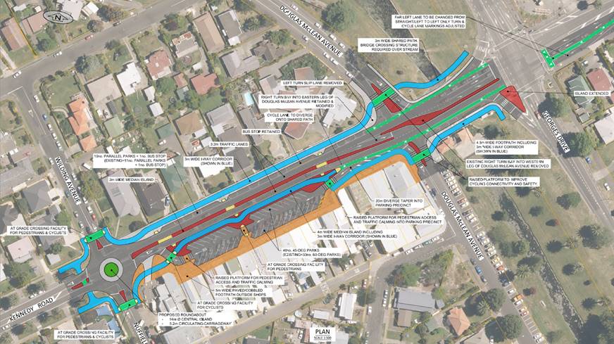
Plan 1 – Original concept design (NTS)
Feedback highlighted that accessibility to the parking area was a key consideration for the property owners who requested that a roundabout at Douglas McLean Avenue be investigated.
In addition to accessibility, there were concerns that if the footpath and kerb line were to be altered then the construction period would be greatly increased which would impact businesses financially.
All of the feedback was considered and the concept plan was revised following detailed traffic modelling of the roundabout option which was followed by an internal safety review. The two roundabout concept is shown at Plan 2, below.
This was presented to the stakeholder group in May 2019 at a second on street consultation event. This consultation was, in the main, very positive with the attendees being supportive of the revised plan. The plan was displayed at two of the businesses for several months following the consultation.
Plan 2 – Revised two roundabout concept design (NTS)
Following this positive consultation, it was decided to proceed to detail design of the project which included an independent safety audit. The independent safety audit raised some concerns with the design of the roundabouts including cyclist safety at the roundabouts; movements across Kennedy Road by vulnerable users; conflicts at the entry and exit to the parking area; and the geometric design of the roundabouts. These concerns were given consideration and the design developed further.
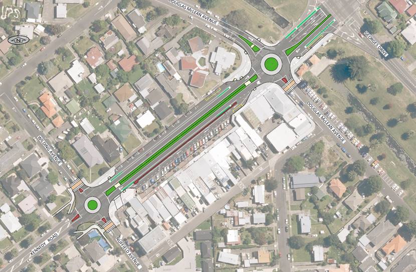
Both roundabouts were altered and linked to the median island effectively forming a single elongated roundabout. This enabled all existing traffic movements to be retained, but removed a number of conflicts, increasing cycle safety, improving pedestrian accessibility and creating a slower environment for vehicles entering the area. The concept is shown below as Plan 3 with larger version at Appendix A.
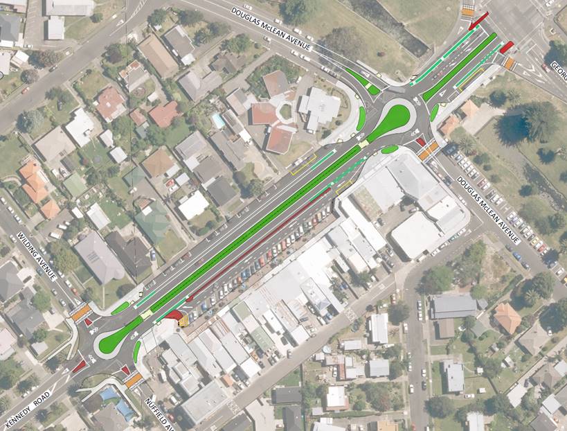
Plan 3 – Final concept design (NTS)
This concept was reassessed via a further independent road safety audit, with the auditor acknowledging the improvements over the previous design. A number of minor observations were made, which will be incorporated into the design as it progresses from concept to detail stage.
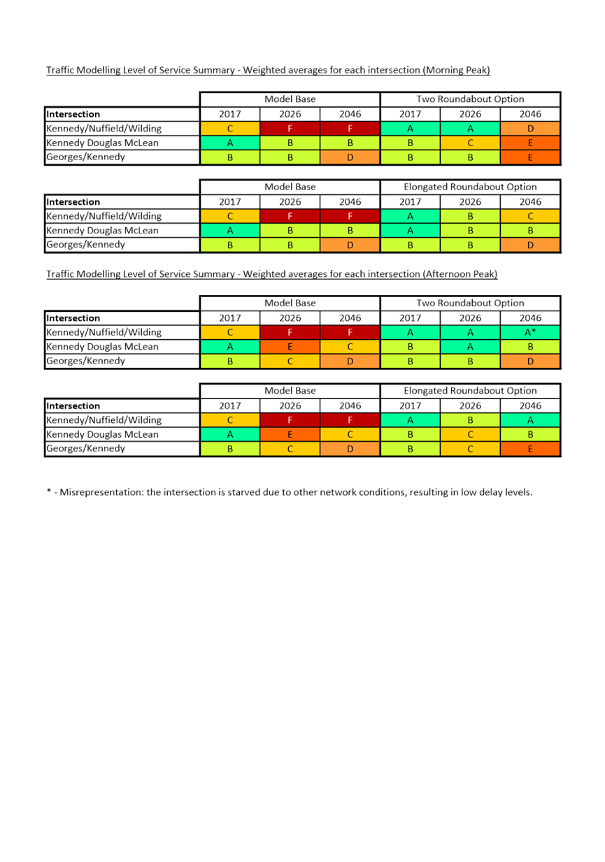
Given the proximity of the project area to the George’s Drive (SH51)/Kennedy Road intersection, the concept was modelled using the citywide micro-simulation model for the model base year of 2017 and future scenarios of 2026 and 2046. This was undertaken to ensure that the major intersection with the State Highway would not be adversely affected. A summary of the model output for both the ‘Two Roundabout’ and ‘Elongated Roundabout’ options is included at Appendix B.
For the preferred, elongated roundabout option, the results of the modelling shows overall improvements at each of the three intersections, although some movements will see some increased delay in the future scenarios due to unbalanced demands. Queue build-up at the Georges Drive/Kennedy Road intersection for City-bound vehicles is not significant for the morning peak, in the afternoon peak it is marginally longer compared to the base scenario.
This model output provides a good level of confidence that the key movement functions of the State Highway and Kennedy Road will be retained. Additional delays to the through traffic on Kennedy Road would result in travellers shifting to an alternative route, which will generally be less favourable than using the arterial route. Further, the delays experienced on side roads would generally be self-regulating to a degree (those who live on the routes served will continue to use them, those seeking short cuts would divert to routes with lower delays). This effectively reduces the impact of increasing volumes on the residential streets and aligns with Council’s intent of making sure the right traffic is using the right roads.
3.3 Issues
Given the high level of use of the neighbourhood centre and Kennedy Road, the project will be of interest to the wider Napier Community. Consultation to date has concentrated on understanding the needs of stakeholders to assist with developing a design that meets critical needs.
The project has been the subject of some misinformation circulating among the stakeholders and concerns raised by this resulted in a petition being presented to Council. This was addressed by the project team in October 2019 at a community meeting held at Kennedy Park and attended by Mayor Wise.
Once stakeholders understood what was proposed and were able to put the rumours aside, the feedback was very positive and the proposed concept approved by all attendees.
Further consultation was undertaken with representatives of Blind and Low Vision NZ, who have assisted the project team in working towards a truly accessible environment. This relationship will continue as the design progresses.
Future engagement will comprise general information on the project, its objectives, scope and design; followed by a more targeted engagement with stakeholders to ensure that construction has a minimal impact on the vibrancy of the area.
Subject to the Council’s decision on this paper, the project team will develop a communications and engagement strategy to inform the form and programme of engagement.
3.4 Significance and Engagement
This project does not meet the criteria of the Significance and Engagement Policy
3.5 Implications
Financial
The project is budgeted for within the Long Term Plan and is approved for funding assistance from NZTA. Capital funding for the project is proposed to be deferred to the 2020/21 Financial Year to allow community engagement to occur and detailed design to be developed.
The evolutions of the project design have not resulted in major increases in estimated project cost.
Social & Policy
The intent of the project is to improve safety for road users, particularly vulnerable road users. Marewa shops provide key social functions for the community including doctors’ surgery, pharmacy, post shop and cafes. Further, regular bus services have stops within the precinct boundaries. Ensuring a safe, accessible and pleasant environment assists these activities and supports their continued viability and availability to the community.
Risk
Not continuing with the project or delaying further exposes users to an acknowledged sub-optimal road environment.
There are risks relating to accessibility during construction which may impact businesses; and there may be a reduction in customer numbers as drivers become accustomed to the new layout.
To address these risks, the construction methodology will be developed to minimise the impact of construction. Once constructed, easier crossing of Kennedy Road and the opportunity to U-turn to access parking or continue a journey should balance any customers lost from not being able to turn in at the last moment when seeing an available parking space.
3.6 Options
The options available to Council are as follows:
a. Do nothing.
b. Progress the latest concept as the most suitable to address the underlying safety risks for all road users and supporting the local community and economy.
c. Continue to investigate further options.
3.7 Development of Preferred Option
As outlined above considerable effort has gone into determining the preferred design option through an iterative, transparent process. Through multiple stakeholder engagement meetings, public consultation and safety audits the design has progressed to a stage where all stakeholders have been heard and their observations are represented where practical. There are still several key design stages to progress though that provide an opportunity to address any further technical issues that may arise.
Some stakeholders have indicated a preference for the ‘Two Roundabout’ design which gives greater freedom of movement to vehicles, particularly at the Douglas McLean/Kennedy Road intersection. This is correct but comes at a cost with a number of compromises identified. Firstly, the full roundabout option presents an additional give-way on Kennedy Road, the main arterial. This increases the risk of drivers selecting an alternative route, which will often include less appropriate roads. Secondly, the inclusion of the roundabout enables a direct connection between the northern and southern sections of Douglas McLean Avenue, duplicating the State Highway but avoiding traffic signals and railway crossings. Modelling showed a significant increase in traffic volumes on Douglas McLean Avenue under this scenario. These diverted vehicles introduce further delay to the main road traffic. Thirdly, while roundabouts are an excellent way to manage traffic, the fewer conflicts between all road users provides for better outcomes and the preferred option has fewer points of conflict between vehicles and other modes.
Further concerns have been raised about potential effects of drivers using the rear service lane as a short cut to bypass the area of higher activity on Kennedy Road. This is unlikely to occur, as the time taken to negotiate the service lane and then give way onto either Douglas McLean Avenue or Nuffield Avenue would not be less than using the formal routes. Notwithstanding this, the Transportation team will undertake post-construction monitoring of speeds around the area and manage any problem areas. This may include adding to the speed humps in the service lane.
There is always an option to continue investigating alternative ways of addressing a problem in an effort to minimise compromises and provide a more complete solution. This project has a number of conflicting priorities and these have been considered from the outset. The designs have been developed through an iterative process and have involved Council engineers, designers and planners, external engineers and independent auditors. It is considered that the elongated roundabout option presents a solution to the identified problems and accommodates a wide range of modes and users without introducing unmanageable compromises to any group.
a Marewa Safety Improvements - Preferred Option Plan ⇩
b Summary of traffic model outputs. ⇩
Extraordinary Meeting of Council - 09 April 2020 - Open Agenda Item 4
4. Quarterly Report for the six months ended 31 December 2019
|
Type of Report: |
Legal and Operational |
|
Legal Reference: |
Local Government Act 2002 |
|
Document ID: |
895738 |
|
Reporting Officer/s & Unit: |
Caroline Thomson, Chief Financial Officer |
4.1 Purpose of Report
To consider the Quarterly Report for the six months ended 31 December 2019.
|
That Council: a. Receive the Quarterly Report for the six months ended 31 December 2019. |
|
That the Council resolve that the officer’s recommendation be adopted. |
4.2 Background Summary
The Quarterly Report summarises the Council’s progress in the second quarter of 2019/20 towards fulfilling the intentions outlined in the Annual Plan. Quarterly performance is assessed against income, total operating expenditure, and capital expenditure.
4.3 Issues
No issues
4.4 Significance and Engagement
N/A
4.5 Implications
Financial
N/A
Social & Policy
N/A
Risk
N/A
4.6 Development of Preferred Option
Receive the quarterly report for the six months ended 31 December 2019.
a Quarterly report for the six months ended 31 December 2019 (Under Separate Cover) ⇨
Extraordinary Meeting of Council - 09 April 2020 - Open Agenda Item 5
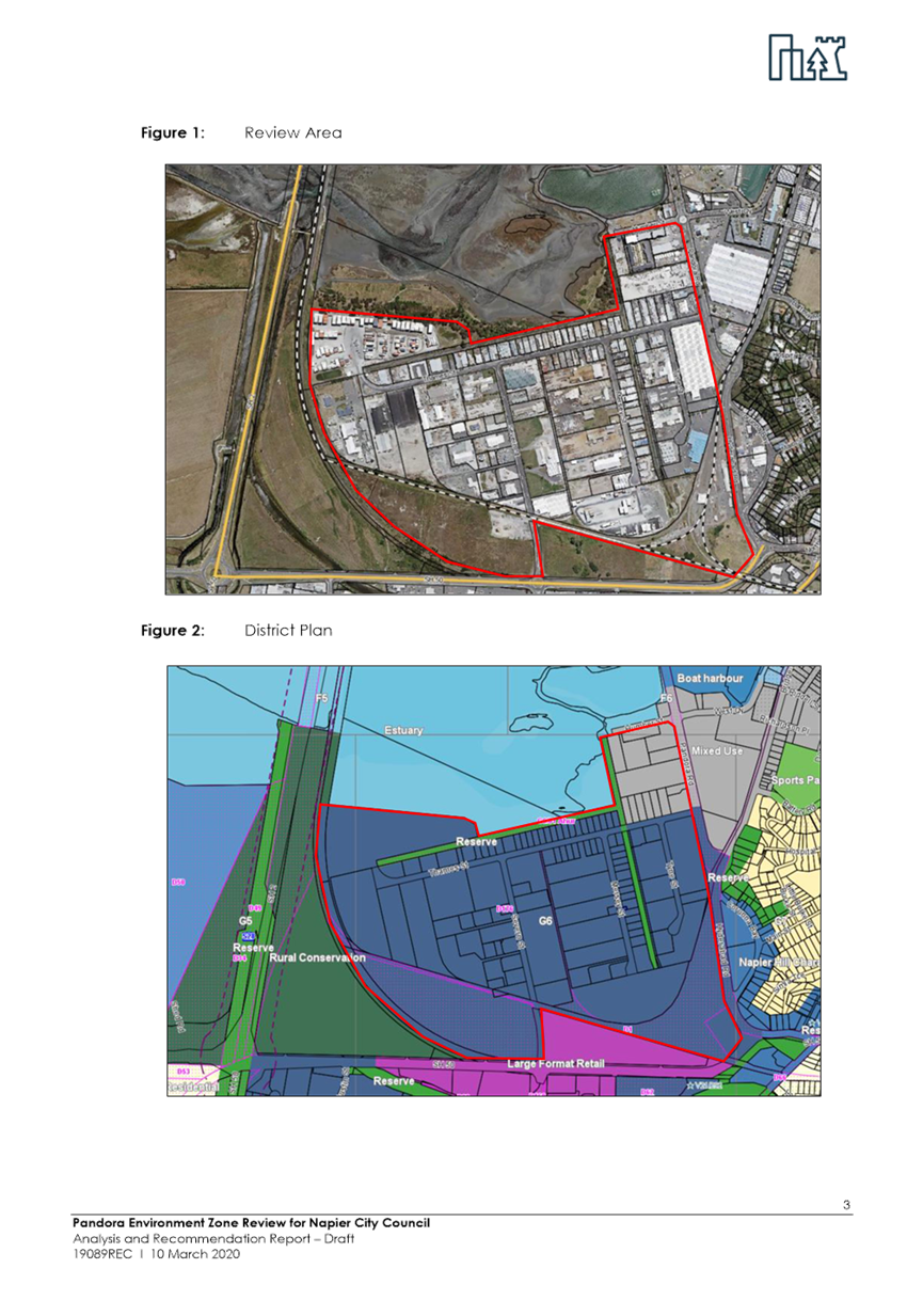
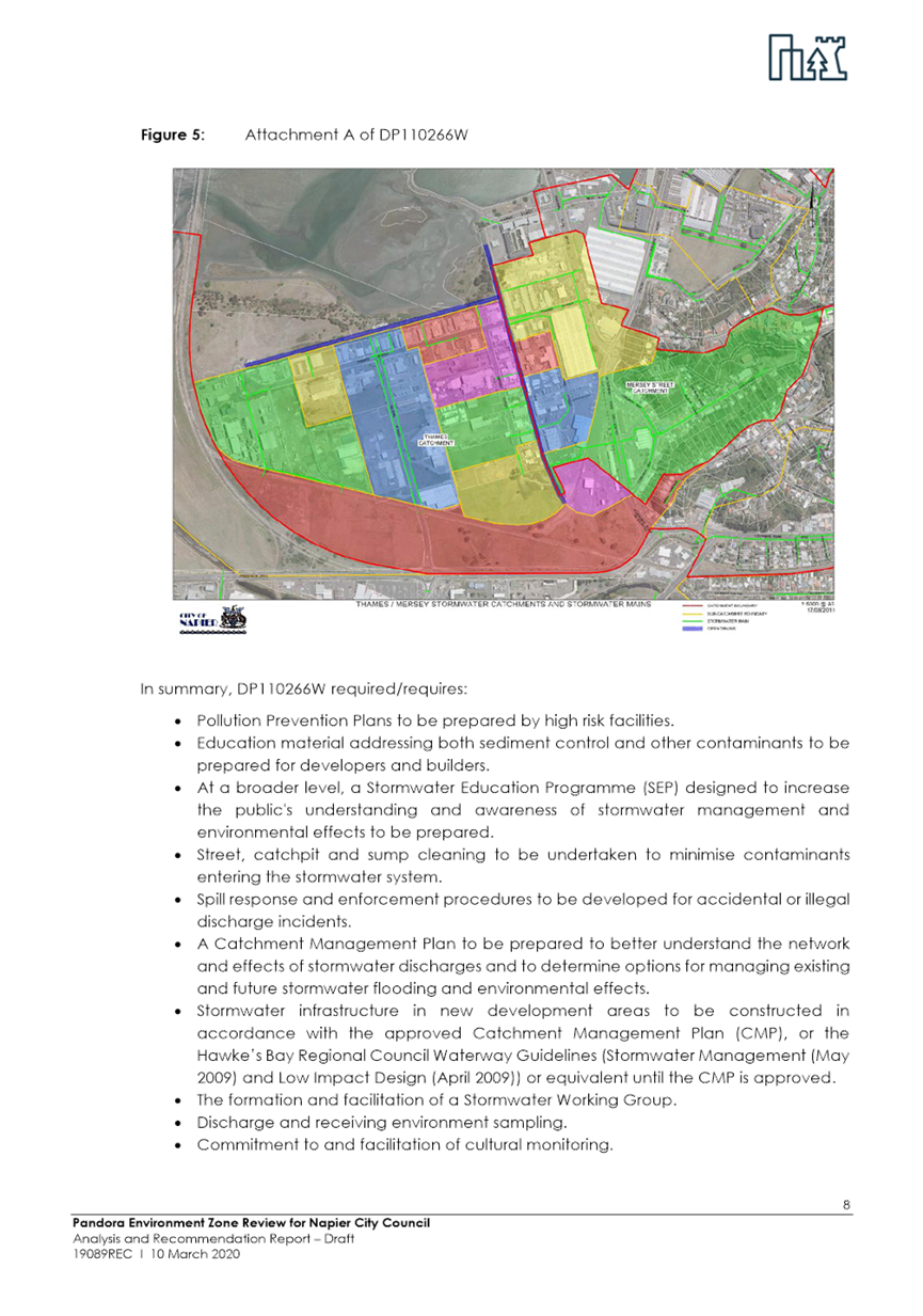
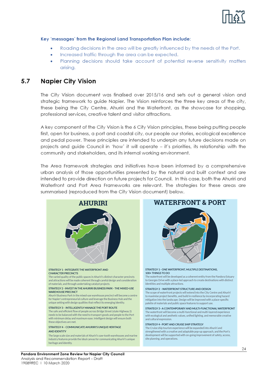
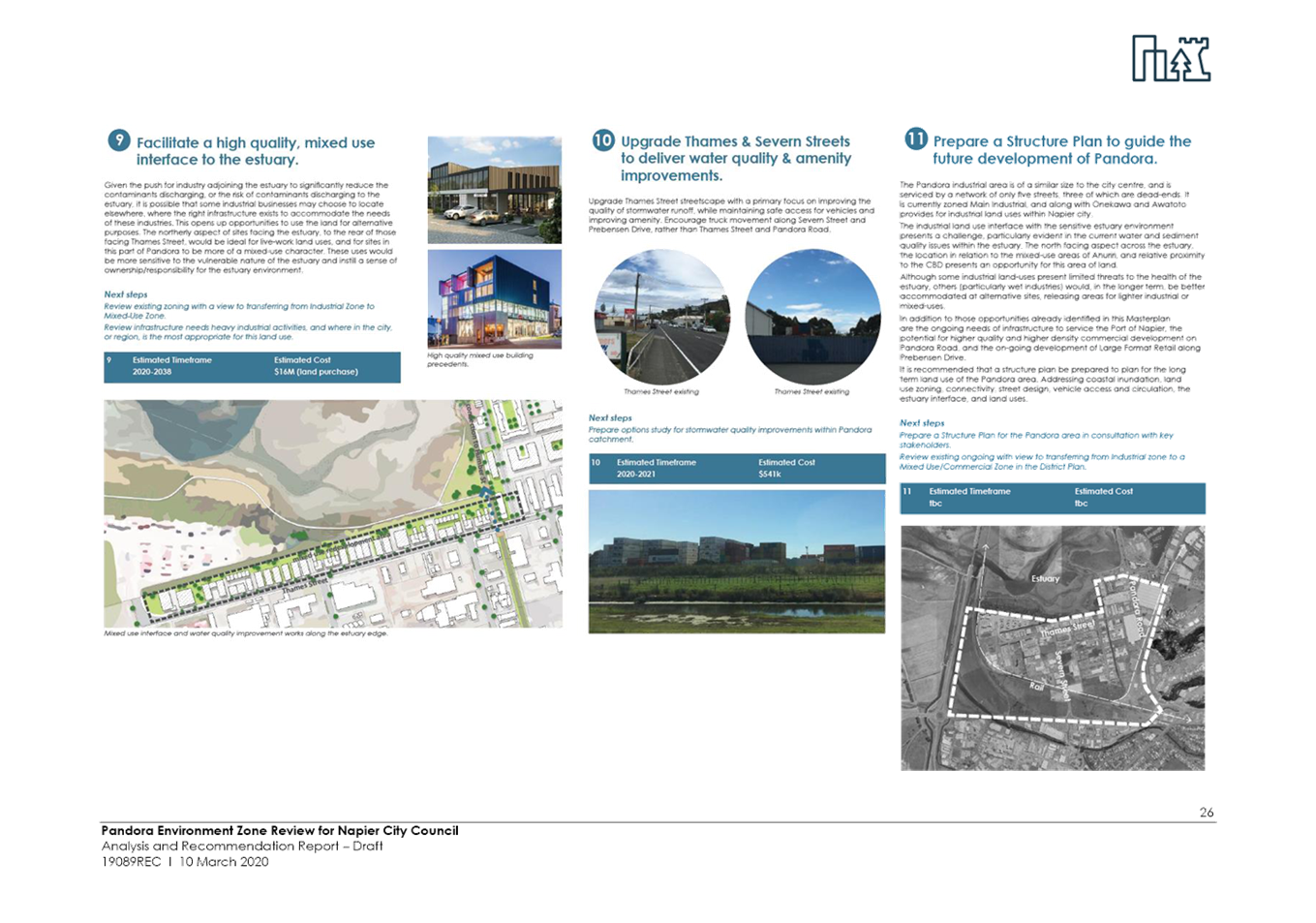
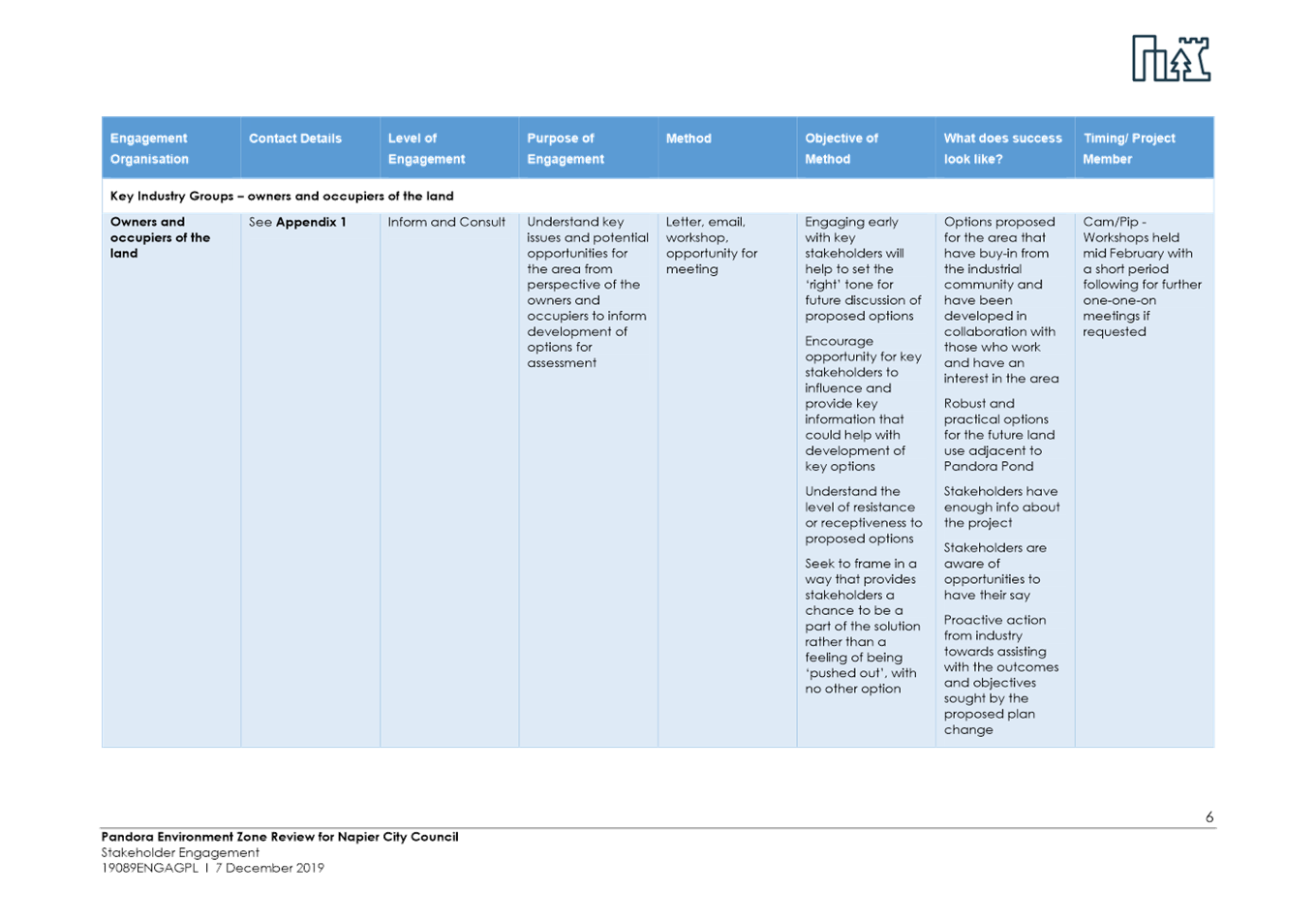
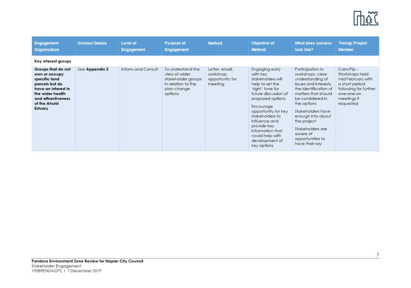
5. District Plan Review - Pandora Industrial Area Rezoning Options
|
Type of Report: |
Legal and Operational |
|
Legal Reference: |
Resource Management Act 1991 |
|
Document ID: |
910369 |
|
Reporting Officer/s & Unit: |
Catherine Reaburn, Senior Policy Planner |
5.1 Purpose of Report
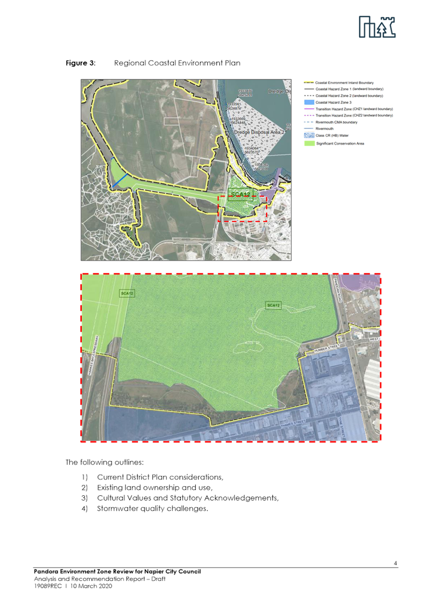
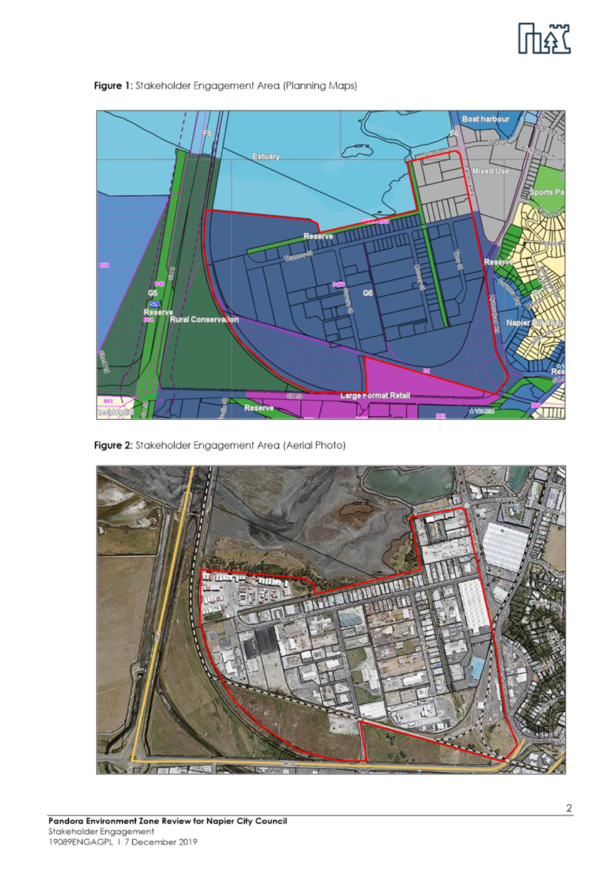
To obtain endorsement from Council to proceed with further analysis and stakeholder engagement on a potential Stormwater Overlay for the full Pandora Industrial Area; and relaxation of the existing Mixed Use Zone at Pandora (for the land between Pandora Road, Humber Street and Thames Street). No change in zoning for the existing Industrial zone is currently proposed.
|
That Council: a. Endorse officers to proceed with further analysis and stakeholder engagement on Option 4: Stormwater Overlay and relaxation of existing Mixed Use Zone; and b. To request officers to report the conclusions of the further analysis and stakeholder engagement for Council’s consideration prior to adopting a policy position for the draft District Plan release in November 2020 |
|
That the Council resolve that the officer’s recommendation be adopted.
|
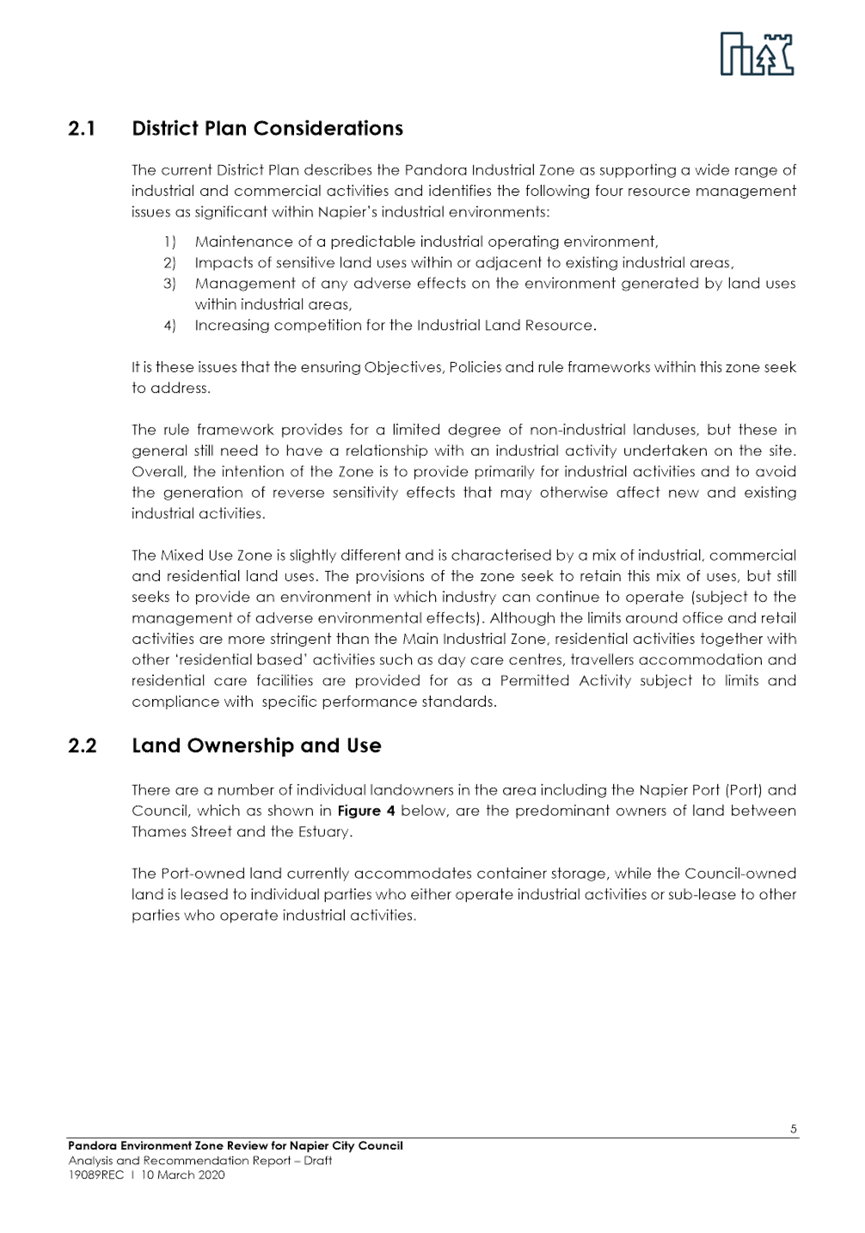
5.2 Background Summary
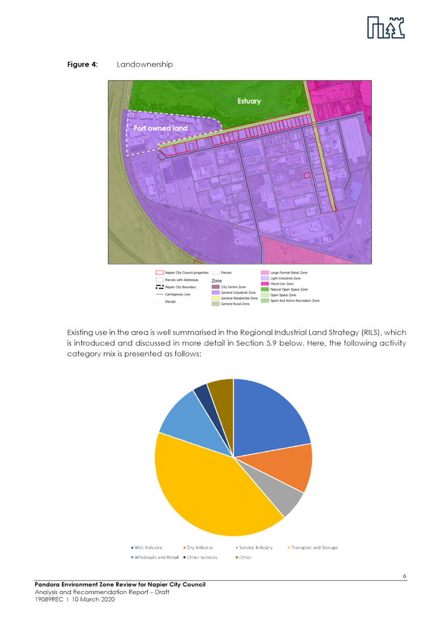
As part of the District Plan Review, a report has been commissioned from external consultants (Stradegy) to inform the zoning and planning provisions for the Pandora Industrial Area. This report is attached as Appendix A. The review seeks to determine the most appropriate planning response to give effect to the key outcome sought from various Council’s strategies and policy directives, including the Ahuriri Estuary and Coastal Edge Masterplan and the draft Regional Industrial Land Strategy. There also needs to be due consideration given to the legislative requirements set by the Resource Management Act and all related documents stemming from this Act.
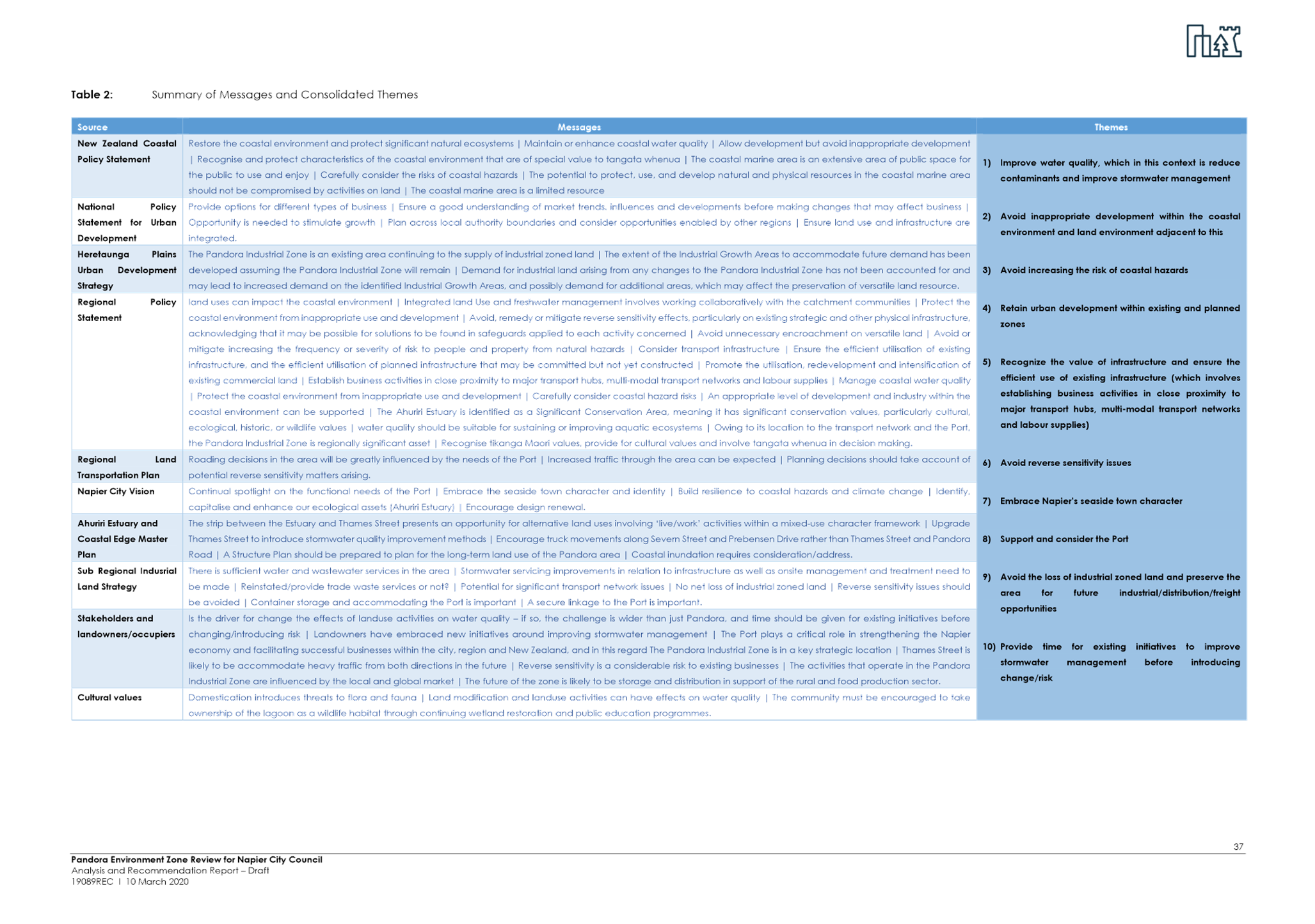
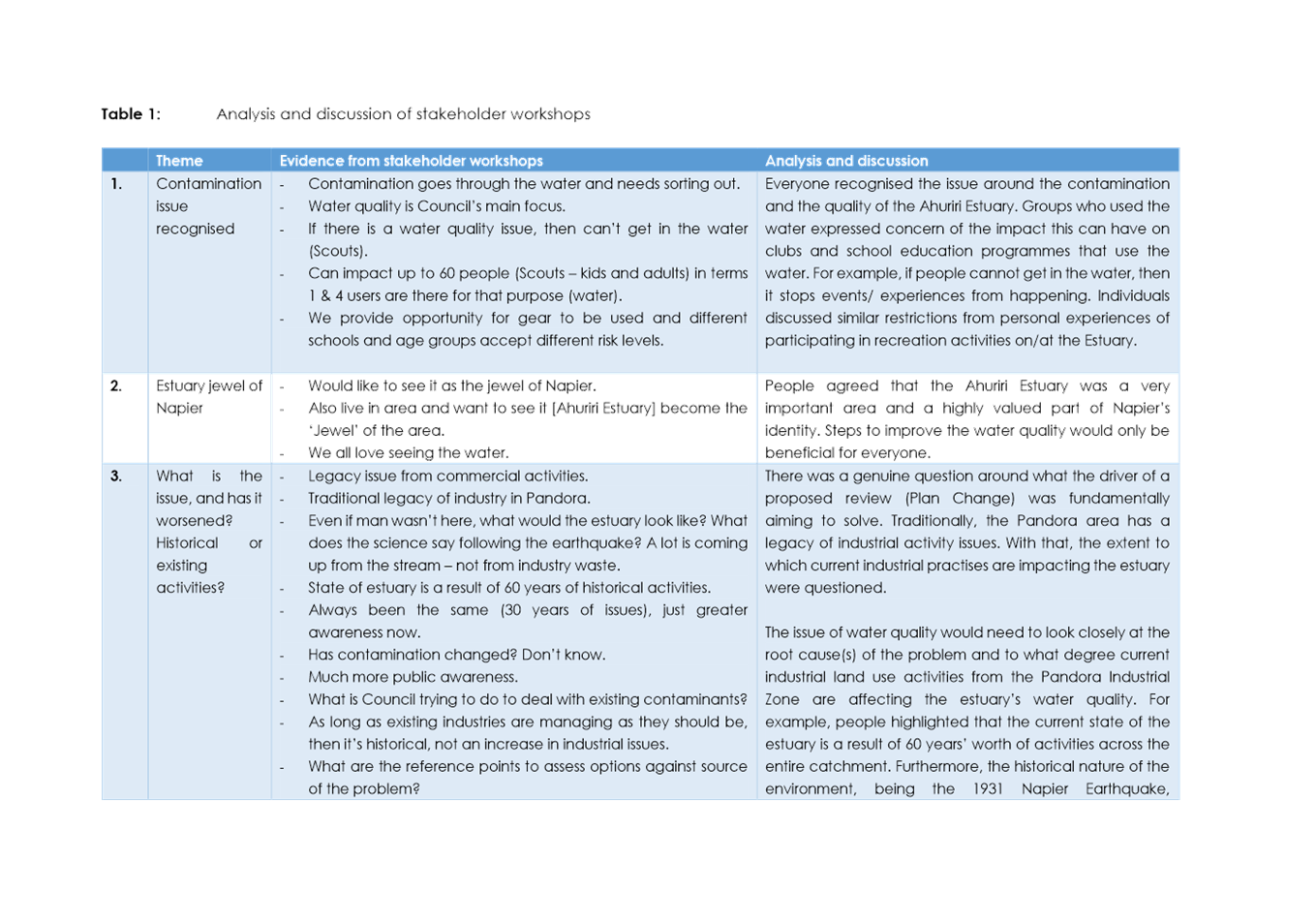
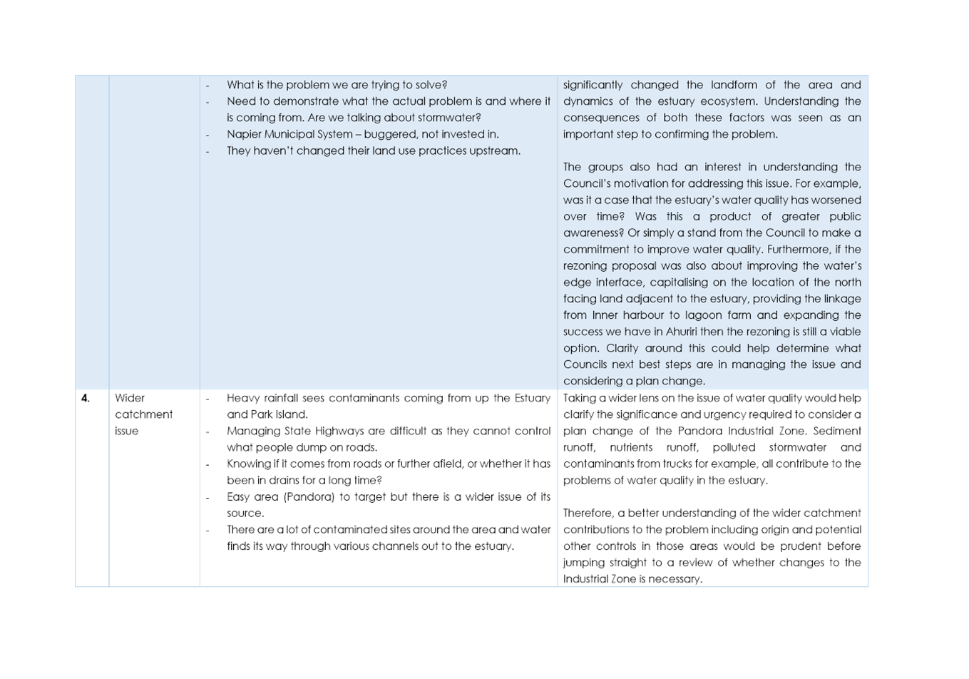
Key themes from the relevant strategies, policy directives and from preliminary engagement with key stakeholders, were summarised for the purpose of analysing different planning response options. The key themes identified are:
1. Improve water quality, which in this context is reduce contaminants and improve stormwater management
2. Avoid inappropriate development within the coastal environment and land environment adjacent to this
3. Avoid increasing the risk of coastal hazards
4. Retain urban development within existing and planned zones
5. Recognize the value of infrastructure and ensure the efficient use of existing infrastructure (which involves establishing business activities in close proximity to major transport hubs, multi-modal transport networks and labour supplies)
6. Avoid reverse sensitivity issues
7. Embrace Napier’s seaside town character
8. Support and consider the Port
9. Avoid the loss of industrial zoned land and preserve the area for future industrial/distribution/freight opportunities
10. Provide time for existing initiatives to improve stormwater management before introducing change/risk
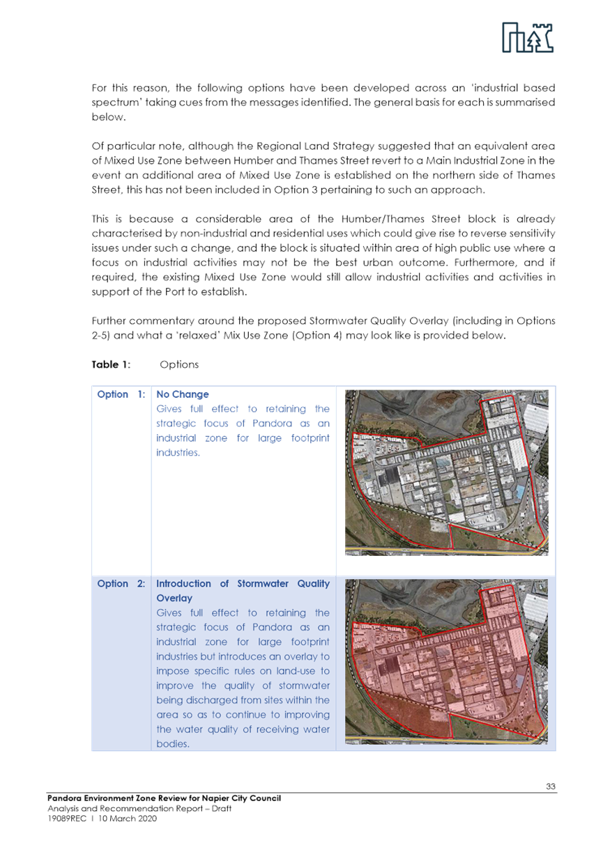
The options analysed are:
Option 1: No Change (status quo)
Option 2: Introduction of a Stormwater Quality Overlay
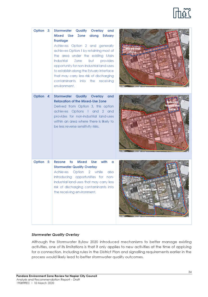
Option 3: Stormwater Quality Overlay and Mixed Use Zone along Estuary Frontage
Option 3A: Mixed-Use Zone along Estuary Frontage
Option 4: Stormwater Quality Overlay and Relaxation of the Existing Mixed-Use Zone
Option 4A: Relaxation of the Existing Mixed-Use Zone
Option 5: Rezone to Mixed-Use with a Stormwater Quality Overlay
Option 5A: Rezone to Mixed-Use
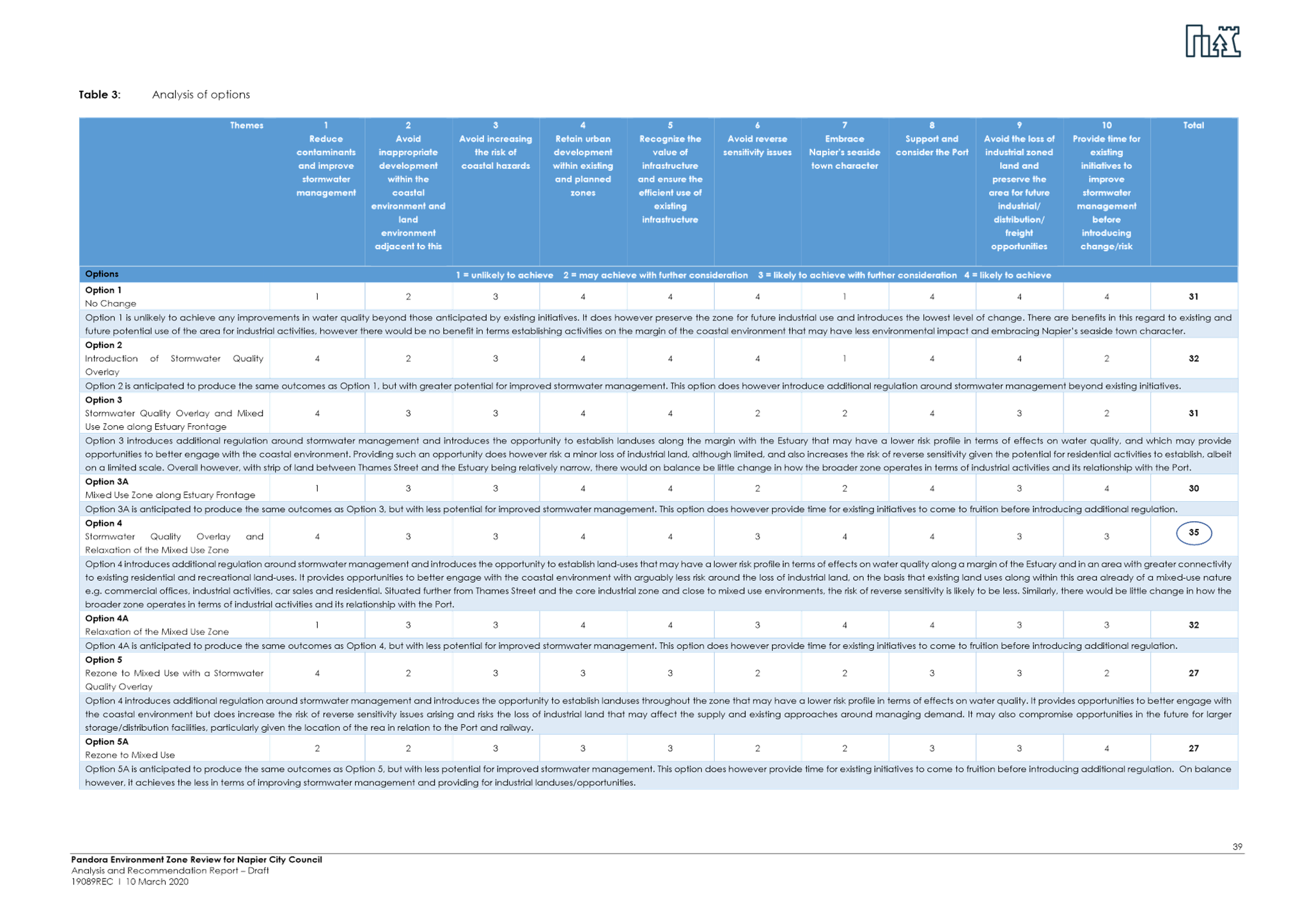
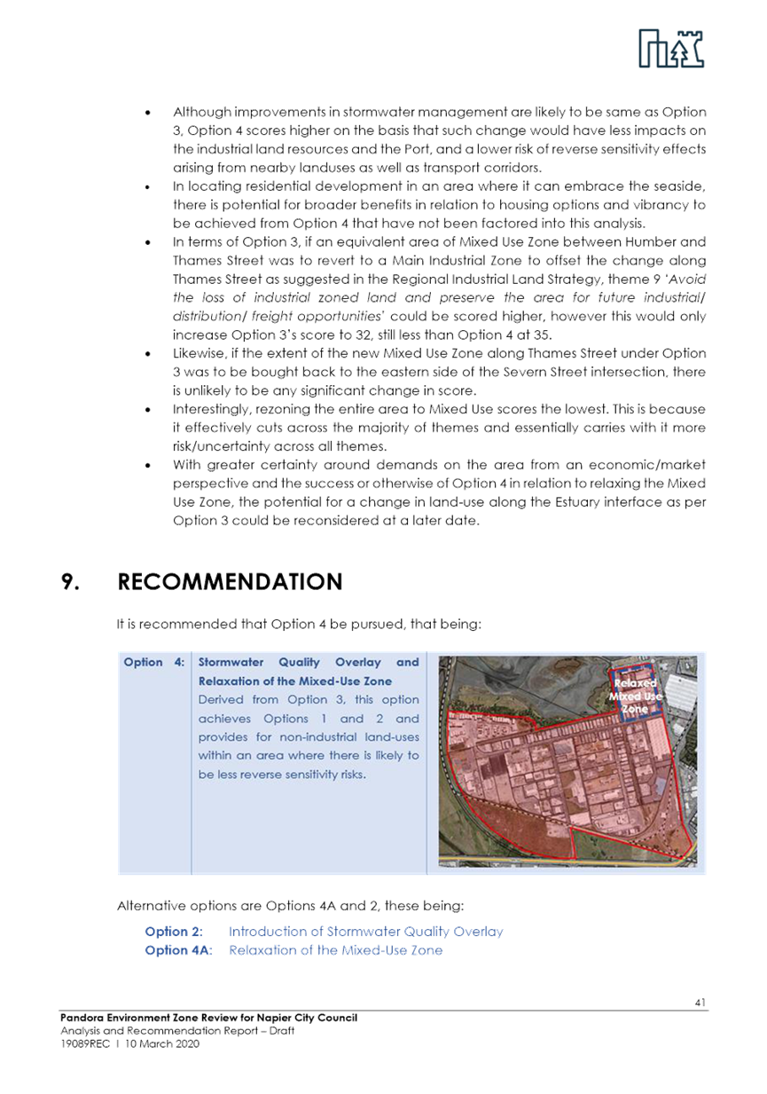
The review recommends that Council progress with Option 4: Stormwater Quality Overlay and Relaxation of the Existing Mixed-Use Zone. In order to progress this option to the next stage the report recommended the following actions:
· Undertake engagement with Tangata Whenua and affected landowners/occupiers
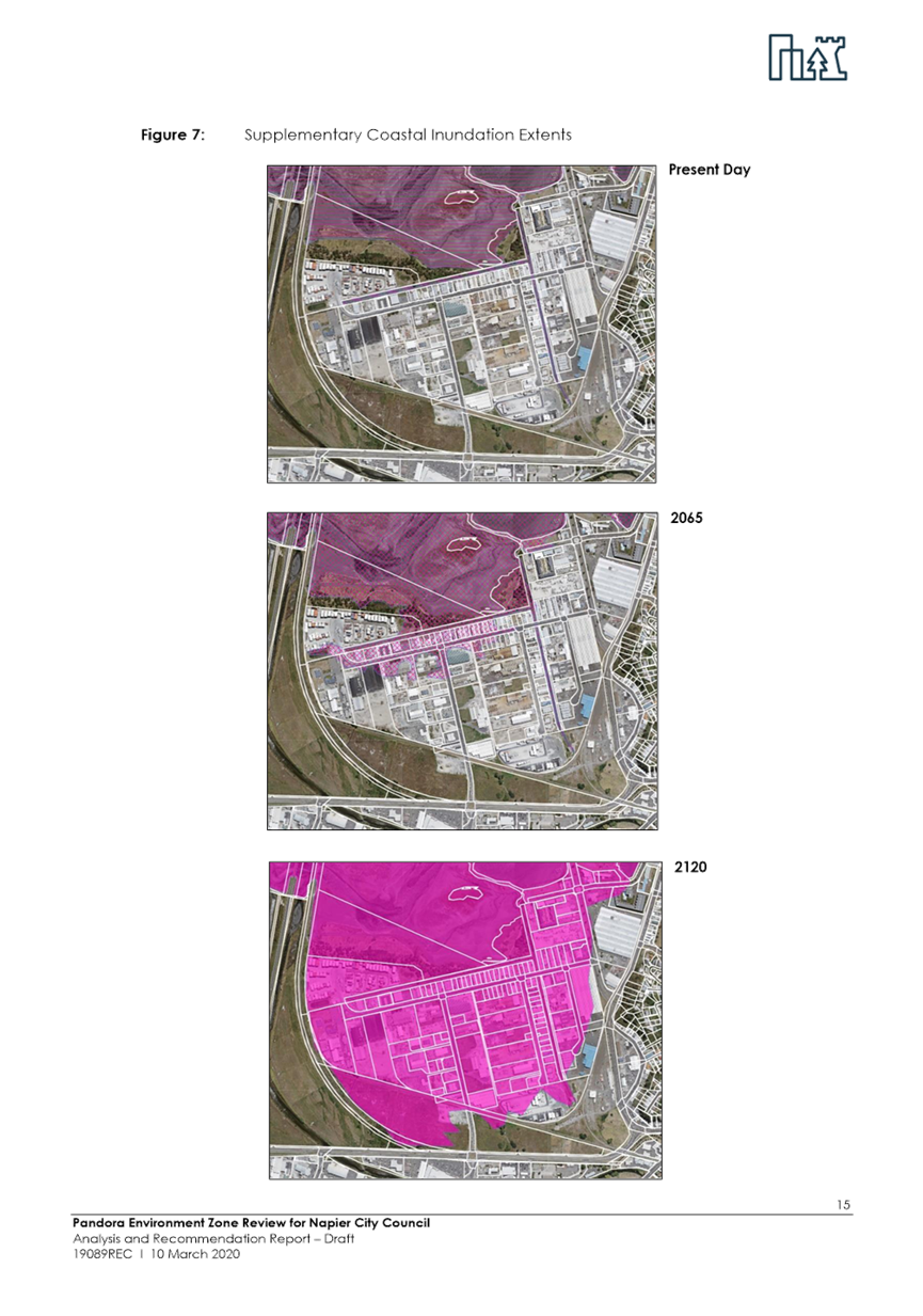
· Assess the implications of potential coastal inundation over the Mixed-Use Zone to be relaxed
· Confirm servicing capacity
· Consider the extent to which the Mixed Use Zone is to be relaxed – e.g. enable quality medium density housing
· Assess and quantify potential effects on industrial land capacity
· Develop a Master Plan to guide the pattern of development and connectivity to roads and areas of public open space
· Develop rules and/or conditions to be included in the District Plan to improve stormwater management on sites within the area, in line with the Stormwater Bylaw 2020
The review concludes that the potential for a change in land-use along the Estuary interface as per Option 3 could be reconsidered at a later date.
This report seeks endorsement from Council to pursue with the recommendations of the review. The outcome of the further engagement and analysis will be reported back to Council for consideration prior to release of the draft District Plan in November 2020.
5.3 Issues
The potential rezoning of land needs to follow due legislative process. The recommendation at this stage involved scoping options and recommending a preferred approach for achieving Councils overall strategic objectives for the Pandora area. Adoption of the recommendation in this report will trigger initiation of the next stage of preparing the necessary documentation to support a rezoning and imposition of a new overlay, provided it meets the tests prescribed by the Resource Management Act. It is envisaged that at the completion of this stage the proposal (if adopted) would become part of the Draft District Plan.
5.4 Significance and Engagement
The zoning and planning provisions for Pandora are significant for all landowners and business operators in the area, as well as the community more broadly given the potential impacts on the Ahuriri Estuary, the transportation network and economic wellbeing.
Stradegy has already undertaken engagement with key stakeholders, landowners and business owners as part of the initial review. The recommendations include engagement with tangata whenua and further discussions with landowners and business owners in further analysing Option 4. This allows more targeted engagement on a specific planning approach.
The further analysis will inform Council’s policy position for release of the non-statutory draft District Plan for feedback in November 2020 – February 2021. This will provide a major opportunity for people to understand how Councils overall objectives and strategic directions manifest themselves in specific plan provisions, including in the Pandora area, and to provide feedback/comments. Feedback on the draft District Plan will inform development of the formal proposed District Plan to be released for submissions in 2021.
There are therefore multiple opportunities for engagement with stakeholders and the wider community throughout the District Plan Review process.
5.5 Implications
Financial
The cost of the additional analysis and engagement will be funded from the existing District Plan Review budget.
Social & Policy
The review seeks to ensure that the District Plan provisions for Pandora align with Council’s current strategic priorities, plans and policies. The further analysis on Option 4 recommended by the review will provide more information to enable Council to make an informed policy position to be included as part of the release of the draft District Plan.
Risk
The risk in not adopting the recommendation is that either:
- There will be insufficient information to inform decision making on a policy position for Pandora for the draft District Plan; or
- An alternative option is selected which may not meet the strategies and policies of Council and/or the legislative requirements of the Resource Management Act 1991.
5.6 Options
The options available to Council are as follows:
a. Endorse officers to proceed with further analysis and stakeholder engagement on Option 4: Stormwater Overlay and relaxation of existing Mixed Use Zone; or
b. Request officers to further consider alternative options.
5.7 Development of Preferred Option
The preferred option is for Council to proceed with additional analysis and engagement on the recommended option. This will assist officers in having sufficient information to provide a recommended policy position for Pandora that meets the legislative requirements of the Resource Management Act 1991 and that can be included into the Draft District Plan.
a Pandora Zone Review - Final Draft ⇩
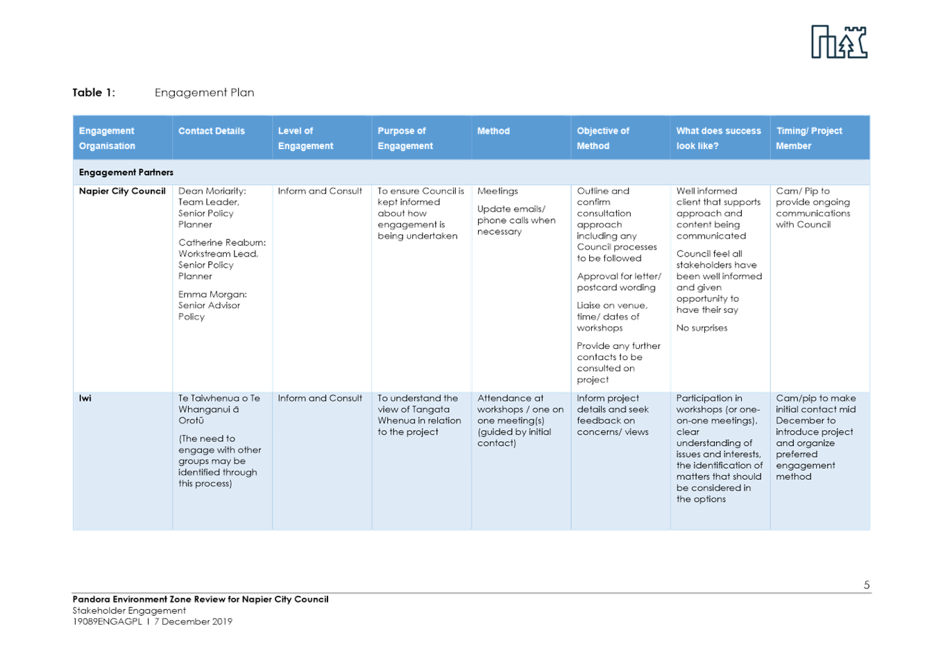
6. District Plan Review - Recommended Policy Approach for Stakeholder Engagement
|
Type of Report: |
Legal and Operational |
|
Legal Reference: |
Resource Management Act 1991 |
|
Document ID: |
909359 |
|
Reporting Officer/s & Unit: |
Dean Moriarity, Team Leader Policy Planning |
6.1 Purpose of Report
The purpose of this report is to:
a. Follow up on the recent series of seminars held with Council between 17th December 2019 – 5th March 2020 regarding the review of the District Plan; and
b. for Council to approve ‘in principle’ the recommended policy approach for specific work streams so that officers can undertake engagement with key stakeholders.
The emphasis at this stage has been to identify landowners who may be affected by provisions potentially impacting on their property rights for issues involving a public good component. This includes provisions on landscapes, historic heritage, biodiversity, and new growth options in the hills. We have initiated engagement with these people in order to capture their views and opinions prior to preparation and release of a Draft District Plan.
|
That Council: a. Endorse ‘in principle’ the recommended policy approach outlined in Appendix A for specific work streams involving a public good component in order to engage with key stakeholders prior to preparing a Draft District Plan; and b. To request officers to report on the conclusions of the stakeholder engagement for Council’s consideration, prior to adopting a policy position for the draft District Plan release in November 2020.
|
|
That the Council resolve that the officer’s recommendation be adopted. |
6.2 Background Summary
Officers have previously presented a paper to Council in August 2018 which showed a recommended strategic direction for the review of the District Plan consisting of ‘Outcomes’, ‘Key Principles’, and ‘Strategic Objectives’. These cascade down from each other to create an overall strategic direction for the District Plan review. The strategic direction was endorsed by Council at the time.
Subsequently a paper was presented to Council in June 2019 which identified how those outcomes, key principles and strategic objectives would be taken into account in drafting specific chapters of the District Plan focussing primarily on the ‘main overall theme/s to achieve the strategic direction. The recommendations from officers for the framework for drafting specific provisions within work streams were itemised at the time and covered the following:
· Residential design provisions
· Residential car parking
· Medium density residential
· City Living for a Vibrant CBD
· Commercial design provisions
· Notable trees
· Pandora industrial area
· Ahuriri
· Art deco signage
· Heritage items
· Heritage character areas
· City centre heritage
· Landscapes
· Ecology
· Coastal environment
· Coastal hazards
· Genetically modified organisms
· Rural production
· Subdivision
More recently a series of seminars were held with Council between 17th December 2019 – 5th March 2020. These seminars recommended policy positions for the work streams with a public good component as a starting point for the purpose of engagement with key stakeholders and members of the public who may be directly affected by provisions in the new District Plan. These policy positions are outlined in Appendix A.
6.3 Issues
A series of detailed reports to support the District Plan review have been commissioned in line with the requirements of the Resource Management Act (RMA), associated National Policy Statements (NPS) and best practice guidance. These reports (which have been provided to Councillors at the time of the seminars) cover:
· Natural features and landscapes
· Historic Heritage (both Heritage Items and Character Areas)
· Ecosystems and Indigenous Biodiversity
· Greenfield growth options in the hills
· Areas of Significance to Maori
6.4 Significance and Engagement
With the exception of Areas of Significance to Maori which is undergoing further engagement with various mana whenua groups prior to finalisation, the reports covering the topics and directions provided at the seminars form the basis of a starting policy position for the purposes of meaningful stakeholder engagement.
Engagement with landowners is at an early stage and is intended to stimulate discussion and feedback prior to preparing the draft plan. Council will be given the opportunity to consider all feedback received and to take this into account when giving guidance to officers as to the shape and form of plan provisions for the Draft Plan. The Draft Plan will provide an opportunity for any interested party to also lodge comments on its provisions in an informal way prior to preparing the Proposed Plan.
The District Plan potentially impacts every person, business and property owner in Napier. A full review of the District Plan typically only occurs once every 10-15 years and provides a unique opportunity for the community to input their views into its development. Given the magnitude of the District Plan review separate engagement/consultation plans may continue to be developed at appropriate times for various work streams during the process to provide meaningful opportunities for feedback. This is one such opportunity targeted at landowners. A separate one will be held in relation to sites of significance to Maori.
6.5 Implications
Financial
There is currently budget set aside for the District Plan review and at this stage progress aligns with the budgetary expectations. Should additional funding be required separate application would be made to Council through the normal budgeting processes.
Social & Policy
The review is a rare opportunity for Council to ensure that the District Plan fully aligns with all of its current strategic priorities, plans and policies. Officers have identified a full list of these that may impact on the District Plan and will endeavour to align the regulatory provisions of the District Plan with the adopted priorities, plans and policies.
Risk
The risk with this project is that should Council decide not to adopt ‘in principle’ an agreed draft policy position for specific workstreams to adopt for the purposes of stakeholder engagement, the scope, complexity, time and resourcing required to deliver the project may expand significantly. This could potentially compromise the quality of the final product.
6.6 Options
The options available to Council are as follows:
a. Adopt ‘in principle’ the recommended policy approach for specific workstreams involving a public good component in order to engage with key stakeholders prior to preparing a Draft District Plan.
b. Not to adopt ‘in principle’ the recommended policy approach for specific workstreams involving a public good component in order to engage with key stakeholders prior to preparing a Draft District Plan.
6.7 Development of Preferred Option
The preferred option is for Council to adopt ‘in principle’ the recommended policy approach for specific workstreams involving a public good component in order to engage with key stakeholders prior to preparing a Draft District Plan. This will assist officers in determining the key issues and potential areas of conflict prior to preparation of a Draft Plan.
a District Plan Review recommended policy positions ⇩
|
Extraordinary Meeting of Council - 9 April 2020 - Attachments
|
Item 6 Attachments a |
Summary of District Plan Review recommendations for Council endorsement
17th December 2019 - 11th March 2020
The preliminary policy position recommendations below will form the basis for landowner engagement where specified (scheduled for March 2020 – April 2020), or otherwise for stakeholder and community engagement through the draft District Plan process (scheduled for November 2020 – February 2021).
Feedback from landowners through the March – April 2020 targeted engagement will be reported to Council mid-2020, and will assist in informing the development of the draft District Plan provisions for release in November 2020 (including revisions to the preliminary policy position where appropriate).
Feedback from stakeholders and the public through the November 2020 – February 2021 draft District Plan engagement will be reported back to Council in early 2021. Council will consider potential revisions to the preliminary policy position in response to feedback prior to notifying the proposed District Plan for formal submissions in 2021.
Greenfield growth in the hills
· Structure Plan: Commence high level structure planning for Taradale Hills and Tironui Drive extension and surrounds areas:
- Consider both servicing within NCC boundary and potential cross-boundary options
- Engagement with landowners (together with other District Plan workstreams – March – April 2020)
· HPUDS growth areas: Identify Taradale Hills, Tironui Drive extension and surrounds, and beyond current NCC boundary and potential growth areas for consideration in the next HPUDS review
· Infrastructure strategies / masterplanning: Consider growth in the hills options in infrastructure strategies / masterplanning for LTP purposes(including stormwater model and wastewater planning)
Residential
· Engagement: To occur through the draft District Plan process (November 2020 – February 2021)
· Preliminary policy position for draft District Plan:
Zoning
· Utilise three key residential zones from the National Planning Standards template:
- General Residential Zone (replaces operative District Plan – Main Residential Zone)
- Medium Density Residential Zone (replaces Marine Parade Character Zone)
- Large Lot Residential Zone (replaces Lifestyle Character Zone (Kent Terrace))
· Do not pursue rezoning of additional residential land to Medium Density Residential Zone (3 storeys) at this time. Revisit through Community Plans process as appropriate.
Housing supply and diversity:
· Reduce onsite private open space requirement for small houses
· One car park per residential unit
· Assessment criteria / design guidance for large scale developments (8+ units) including:
- Accommodate a mix of housing types and sizes
- Provide for a housing type and size to meet an identified demand
- Provide some houses that achieve universal accessibility standards
Safe, active and interactive communities
· Introduce new controls addressing:
- Restriction of front fence height / visual permeability
- Minimum requirement for windows facing the street or public open space from habitable rooms
- Garage door and vehicle crossing width restrictions
- Front yard landscaping
- Assessment criteria / design guidance to minimum cul de sacs and encourage through-site linkages
· Enable small scale home business, day care centres, visitor accommodation and education facilities subject to control
· Allow an additional 5dBA noise limit for day care centres operating in residential zones between 8am – 6pm Monday-Friday to facilitate these activities
Healthy and comfortable living environments
· Retain height in relation to boundary control
· Introduce outlook (privacy and daylight access standards) for Medium Density Residential, Mixed Use and Centres zones
· Assessment criteria / design guidance for multi-unit residential developments to enable consideration of:
- Optimize sunlight access
- Minimize overlooking and shading of neighbours
- Clearly visible, lit and sheltered entranceways to front doors
- Easy storage and access of recycling and rubbish for collection
- Safe and accessible car parking
- Size and layout of unit – space for furniture and to move around
- Easily accessible and identifiable letter boxes
-
· Introduce acoustic insulation requirements in Mixed Use and centres zones, and within 80m of a State Highway or Railway
Neighbourhood Character / Sense of Place
· Retain height, building coverage, minimum landscaping, and yard controls in the General Residential Zone (currently Main Residential Zone), Medium Density Residential Zone (currently Marine Parade Character Zone) and Large Lot Residential Zone (currently Lifestyle Character Zone)
· Introduce additional assessment criteria / design guidance for multi-unit residential developments to require consideration of retaining mature trees if feasible; and to reflect built characteristics of specific neighbourhoods where appropriate e.g. roof forms
Public health and environmental wellbeing
· Assessment criteria / design guidance for multi-unit residential developments to consider site layout and house design for a low energy, warm, dry and healthy living environment
· Design guidance to provide examples e.g. window placement for cross-ventilation; north facing
Regional Industrial Land Strategy
· Release draft Regional Industrial Land Strategy to key stakeholders for feedback
· Council to consider adopting the draft Regional Industrial Land Strategy as a preliminary policy position following consideration of feedback and further area specific seminars
· Strategy to be kept in “final draft” format for wider stakeholder and community engagement through the draft District Plan engagement process (November 2020 – February 2021)
· Draft Regional Industrial Land Strategy strategic direction and recommendations to be considered in infrastructure planning (including stormwater and wastewater masterplanning) for LTP purposes.
Heritage items
· Engagement: Consult with land owners of heritage items (March – April 2020) including:
- Provide research findings and assessment of heritage value to owners
- Seek feedback on draft provisions
- Provide information about funding sources
· Preliminary policy position for landowner engagement:
- Introduce provisions controlling Paint colours in the Napier City Centre Heritage Precinct
- More restrictive provisions for signage in the Napier City Centre Heritage precinct
- Relocation & demolition of Category 1 items elevated from Discretionary to Non-Complying Activity status
- Updated Art Deco Design Guide
- Exploring other opportunities for financial assistance (e.g. Development & Financial Contributions policy, rates, resource consent charges)
Historic character areas
· Engagement: Consult with land owners located within proposed heritage character areas (March – April 2020) including:
- Letters
- Access to online Storymap
- Drop-in sessions
- Feedback received from residents of Railway Housing Area and Napier South will inform Councillors when determining whether to go ahead with the new Character Areas
· Preliminary policy position for landowner engagement:
- General: Removal of advocacy areas – use heritage character precincts with regulatory controls only
- Marewa Art Deco Character Area: expand area; protections to only apply to buildings built prior to 1 January 1950; introduce new rules to avoid placement of accessory buildings and minor residential units in front of dwellings; reduce front fence height
- Marewa State Housing Character Area: slight reduction in area; protections to only apply to buildings built prior to 1 January 1960; introduce new rules to avoid placement of accessory buildings and minor residential units in front of dwellings; reduce front fence height
- Te Awa Bungalow Character Area: increase in size of area to encompass some areas previously covered by Advocacy Area; protections to only apply to buildings built prior to 1 January 1940; introduce new rules to avoid placement of accessory buildings and minor residential units in front of dwellings; reduce front fence height
- Railway Housing Character Area: previously an Advocacy Area with no protection; proposed new Character Area; protections to only apply to buildings built prior to 1 January 1930; maximum building height 5m; one dwelling per 350m²; introduce new rules to avoid placement of accessory buildings and minor residential units in front of dwellings; reduce front fence height
- Hardinge Road Character Area: area reduced to concentrate on Waghorne Street area; renamed Ahuriri Spit Character Area; protections to only apply to buildings built prior to 1 January 1930; introduce new rules to avoid placement of accessory buildings and minor residential units in front of dwellings; new dwellings require resource consent; garages to be stepped back from front boundary; reduce front fence height
- Battery Road Character Area: Battery Road Character & a reduced Coronation Street Character Area combined; renamed Battery Road Character Area; protections relating to alterations/demolition to only apply to buildings built prior to 1 January 1940; introduce new rules to avoid placement of accessory buildings and minor residential units in front of dwellings; new dwellings require resource consent; garages to be stepped back from front boundary; reduce front fence height
- Iron Pot Character Area: Amend boundary of character area (away from Shopping Centre, but extend down Ossian Street); introduce West Quay Waterfront Control Area to provide similar design control in this area as existing West Quay Waterfront Zone; demolitions to rear of building permitted; restrictions on alterations over a certain area; new buildings over a certain size require resource consent/design assessment
- Napier South Character Area: Potential new character area; minimum lot size 500m²; maximum building height 5m; restrictions on alterations and demolition for dwellings built prior to 1 January 1940; resource consent required for new dwellings (design assessment); accessory buildings located to rear of dwellings
Amenity character areas
· Engagement: To occur through the draft District Plan process (November 2020 – February 2021) to enable integration with the potential general residential zone changes
· Preliminary policy position for draft District Plan:
o Napier Hill Character Precinct: Retain provisions of existing Napier Hill Character Zone with the following potential changes (subject to feedback):
§ Building coverage: Reduce from 50% to 40%
§ Minimum landscaping: Increase from 30% to 40%
§ Open space requirements more flexible is steep site – can be provided via a deck or terrace area
o Ahuriri Spit Character Precinct:
§ applies to the remainder of the existing Hardinge Road Character Zone that is not within a heritage character area
§ Potential removal of 3 storey allowance (maximum permitted height of 2 storeys) subject to feedback
Notable trees:
· Engagement: To occur through the draft District Plan process (November 2020 – February 2021) as no notable trees on private property is proposed
· Preliminary policy position for draft District Plan: Draft District Plan to include updated Notable Trees schedule and chapter (no substantial changes to the current District Plan provisions). Feedback through the draft District Plan, including on potential additional notable trees, to be considered by Council prior to notifying the proposed District Plan.
Significant Natural Areas
· Engagement: Consult with land owners located within proposed significant natural areas (March – April 2020) including:
o Letters
o Access to online Storymap
o Drop-in sessions
· Preliminary policy position for landowner engagement:
o 2 tier approach to manage both Significant Natural Areas (SNA) and Locally Significant Natural Areas (LSNA) – lesser degree of regulation for LSNAs e.g. if wanting to subdivide will need to protect
o Agree in principle to consider some form of incentive(s) – details to be worked through following landowner engagement
o Agree in principle to include a 10% goal for increasing vegetation cover (extra 430ha over long term, supports estuary restoration)
Landscapes and Natural Features
· Engagement: Consult with land owners located within proposed landscape protection areas and natural features (March – April 2020) including:
o Letters sent to all property owners in Taradale Hills, Te Whanganui-a-Orotu, Heipipi-Esk Hills
o Access to online Storymap
o Drop-in sessions
· Preliminary policy position for landowner engagement:
o General:
§ Likely to be strong correlation with sites of significance to Māori so regulatory response will need to be co-ordinated at a later date
§ Structure planning for Growth in the Hills areas will consider integrating landscape values
o Ōtātara Pa – Outstanding Natural Feature (6 private properties):
§ Values to protect: Visually prominent, undeveloped, culturally important
§ Resource consent required for most activities with ability to decline depending on assessment of effects
§ Assessment criteria to give certainty around appropriate height, location, colour, landscaping etc
o Te Whanganui-ā-Orotu – Special Character Landscape
§ Values to protect: Openness of former lagoon sea bed, legibility of individual features, ecological values
§ Resource consent requirement for large developments, subdivisions and earthworks
§ Conditions for permitted activities to preserve key values e.g. height limits, recessive colours. Consent required when standards breached
§ May impact on some properties in Poraiti viewed from the estuary
§ Likely to be strong correlation with sites of significance to Māori, so regulatory response will need to be coordinated
o Heipipi / Esk Hills – Landscape Character area
§ Values to protect: High visibility, landmark qualities, cultural associations with Te Whanganui-ā-Orotu
§ Resource consent requirement for buildings, cut and fill earthworks, subdivision over certain threshold (if granted, subject t oconditions mitigating effects on landscape)
§ Assessment criteria to give certainty around appropriate height, location, colour, landscaping etc
§ Likely to be strong correlation with sites of significance to Māori, so regulatory response will need to be coordinated
o Pukekura (Sugar Loaf) – Special Character Feature
§ Primarily applies to Council reserve with only some margins of private property affected
§ Resource consent required for most activities
§ Restricted Discretionary resource consent for new buildings (likely to be granted subject to conditions mitigating effects on landscape)
§ Assessment criteria to give certainty around appropriate height, location, colour, landscaping etc
o Taradale Hills – Special Amenity Landscape
§ Landscape protections to focus on area between Springfield Road and Puketapu Road
§ Apply regulation to all areas above 60m contour (the upper slopes)
§ Restricted Discretionary resource consent required for new buildings, cut and fill earthworks, subdivision over certain threshold (if granted, subject to conditions mitigating effects on landscape)
§ Assessment criteria to give certainty around appropriate height, location, colour, landscaping etc
Pandora
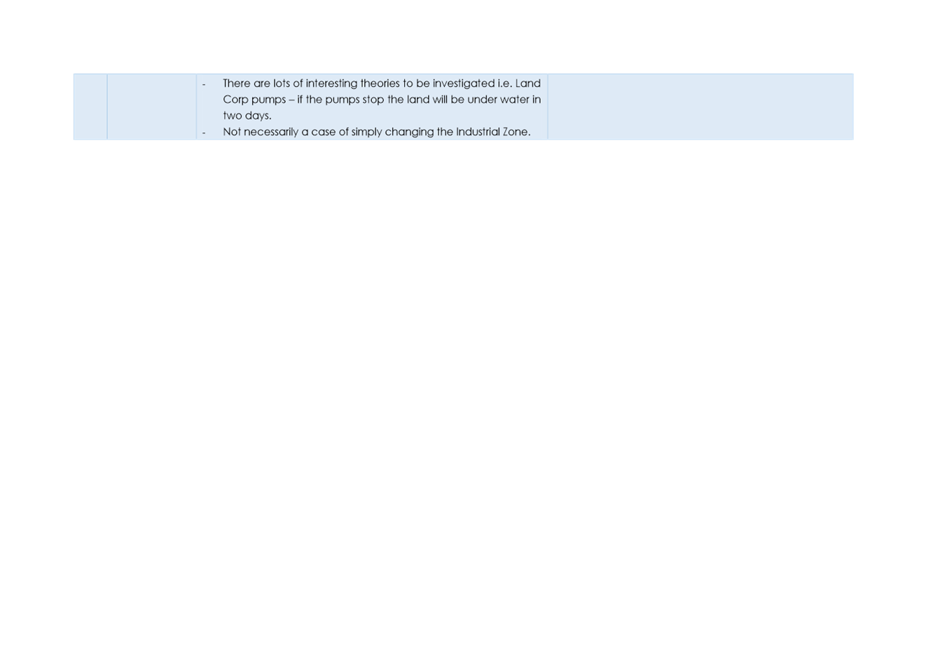
· Preliminary policy position: Progress with analysis for “Option 4: Stormwater Quality Overlay and Relaxation of the existing Mixed-Use Zone”, including:
o Undertake engagement with mana whenua and affected landowners/occupiers
o Assess the implications of potential coastal inundation of the Mixed-use zone to be relaxed
o Confirm servicing/infrastructure capacity
o Consider the extent to which the Mixed-use zone is to be relaxed
o Assess and quantify potential effects on industrial land capacity
o Develop a Master Plan to guide the pattern of development and connectivity to roads and areas of public open space
· Engagement: Develop planning provisions for Option 4 to be included in the draft District Plan for stakeholder and community feedback
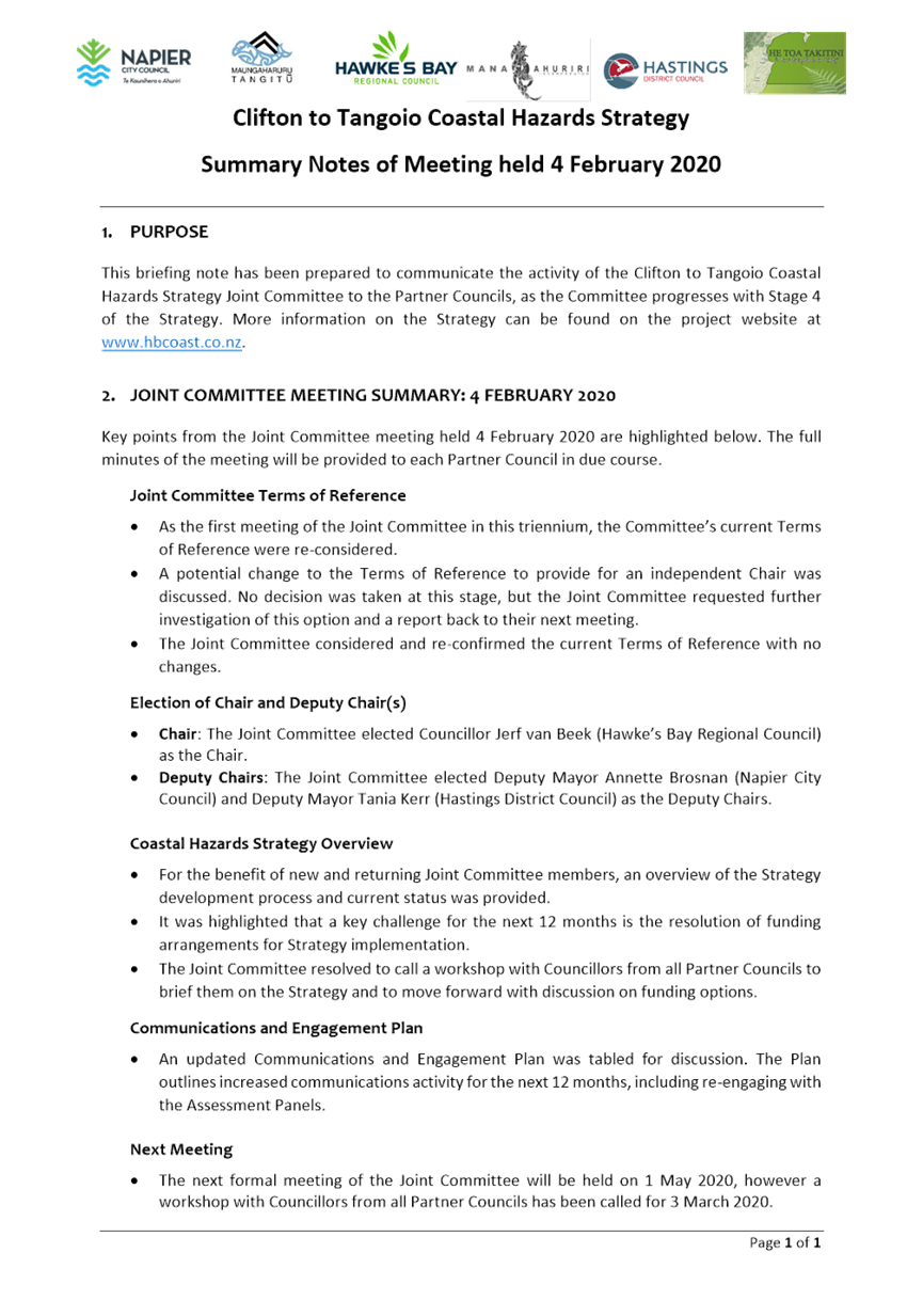
7. Coastal Hazards Strategy - Update from the February Joint Committee Meeting
|
Type of Report: |
Information |
|
Legal Reference: |
Resource Management Act 1991 |
|
Document ID: |
911663 |
|
Reporting Officer/s & Unit: |
Dean Moriarity, Team Leader Policy Planning |
7.1 Purpose of Report
To update Councillors on progress of Stage 4 of the Coastal Hazards Strategy and for Council to adopt the Terms of Reference for the Joint Committee for the next triennium.
|
That Council: a. Note the information contained in the meeting notes from the Coastal Hazards Strategy Joint Committee meeting held 4 February 2020 b. Adopt the Terms of Reference as recommended by the Coastal Hazards Strategy Joint Committee on the meeting held 4 February 2020
|
|
That the Council resolve that the officer’s recommendation be adopted. |
7.2 Background Summary
The Coastal Hazard Strategy was initiated in 2014 and since that time has progressed through Stage 1 (Define the Problem), Stage 2 (Framework for Decisions) and Stage 3 (Develop Responses). The Strategy is now at Stage 4 (Respond) which involves the development of an Implementation Plan for the recommended responses.
7.3 Issues
The Coastal Hazards Strategy is a joint project between Hastings, Napier and the Hawkes Bay Regional Council. Governance of the project is overseen by a joint committee comprised of three Councillors from each of the partner Councils with mayors and the chair of HBRC acting as ex officio members. Councillors Brosnan, Browne and Price represent Napier.
During Stage 4, particularly over the last year, there have been difficulties getting agreement from the partner Councils on some of the big decision points that need to be made to progress the Strategy. Funding of solutions, private versus public benefits, who pays and at what quantum, who collects and administers any contributory fund and for what specified purpose monies will be collected have all proven to be problematic in getting agreement from the respective Councils.
There is concern that the divergence of opinions from the partner Councils arise from Councillors who are not part of the Joint Committee being too removed from the evolution and progress of the Strategy and the complexities associated with developing an agreed implementation plan that has a 100 year horizon. Therefore, it has been agreed that there needs to be more regular engagement with Councillors outside of the Joint Committee which will be in the form of regular updates as to what transpires at each Joint Committee meeting and the opportunity to have seminars following each Joint Committee (individually and collectively) if complex matters are discussed and need to be socialised.
This report is the first in the series of agenda items following each Joint Committee meeting (meeting notes and the opportunity to ask questions directly from a member of staff involved in the technical advisory group) that will be forwarded to Council.
An additional matter arising from the Joint Committee held on the 4 February 2020 meeting is the need to adopt updated the terms of reference for this triennium.
7.4 Significance and Engagement
The Coastal Hazard Strategy triggers Council’s Significance and Engagement Policy. It is, however, a joint strategy with Hastings District Council and Hawkes Bay Regional Council that collectively is of such magnitude that any engagement will need to be held collaboratively and follow its own processes including a special consultative procedure once sufficient certainty on its content is known.
7.5 Implications
Financial
The regular updates from the Joint Committee involve no financial implications. Separate reporting will be needed when financial decisions are made.
Social & Policy
This report is simply providing an update from the Joint Committee meeting to keep Councillors updated.
Risk
This report is simply providing an update from the Joint Committee meeting to keep Councillors updated and as such involves no risk.
7.6 Options
The options available to Council are as follows:
a. Note the information arising from the Joint Committee meeting and adopt the new terms of reference for the next triennium
b. Note the information arising from the Joint Committee meeting and recommend changes back to the Joint Committee regarding the new terms of reference for the next triennium
7.7 Development of Preferred Option
The preferred option is to Note the information arising from the Joint Committee meeting and adopt the new terms of reference for the next triennium. The whole of Council needs to be closely aware of progress of the Coastal Hazards Strategy because of its significance and potential cost implications. Regular updates assist with this. Additionally the Terms of reference have been updated for the next triennium to retain currency but remain in line with the previously adopted version.
a Coastal Hazards Joint Committee - Meeting Summary 4 Feb 2020 ⇩
b ToR Joint Committee January 2020 ⇩
8. Offsite Kiwi Facility Lease
|
Type of Report: |
Contractual |
|
Legal Reference: |
N/A |
|
Document ID: |
904314 |
|
Reporting Officer/s & Unit: |
Rachel Haydon, General Manager, National Aquarium of New Zealand |
a8.1 Purpose of Report
This report is to provide Council with the proposed conditions of a lease between the Napier City Council and Kiwis for Kiwi, so the progression of a lease agreement can be made to occupy and operate the Offsite Kiwi Facility.
|
That Council: a. Approve in principle (including key proposed lease conditions) the leasing of part of the Offsite Kiwi facility to a third party operator, Kiwis for Kiwi. b. Note that a draft lease will come back to Council for approval pursuant to the Reserves Act 1977.
|
|
That the Council resolve that the officer’s recommendation be adopted. |
8.2 Background Summary
The offsite kiwi facility is currently staffed and managed by the National Aquarium of New Zealand team. There are four breeding pairs of brown kiwi (Apteryx mantelli) and a single bird currently residing at Offsite. This facility also provides off-site refuge for the breeding pair housed in the nocturnal house at the Aquarium.
It is a Department of Conservation permitted facility for brown kiwi and undertakes the activities of captive breeding (as a member of the Zoo Aquarium Association, Australasia), incubating eggs, hatching and crecheing chicks, and regular care and husbandry of birds.
The facility was originally linked to the nocturnal house on Marine Parade, which closed in the late 1990s. This nocturnal house was managed by Napier City Council’s Reserves Manager (under Parks & Reserves) and also took care of kiwi at the offsite facility.
In 2002, the Aquarium expansion afforded opportunity for a new nocturnal house, housing brown kiwi which were sourced from the offsite kiwi facility, still managed and bred by the Reserves Manager. The Reserves Manager trained Aquarium staff to care for the kiwi onsite at the Aquarium.
In 2010, the Aquarium team took over the offsite facility upon the Reserves Manager’s retirement, and now with eight years of kiwi care and husbandry experience, the Aquarium staff continue to manage it to present day.
8.3 Issues
Limited time and resources
The offsite facility has remained under the management of the Aquarium team, however current pressure on resources to deliver activity at the offsite facility and the nocturnal house at the Aquarium is becoming unmanageable. Bird keeping staff are based at the Aquarium, with care for penguins in addition to kiwi offsite.
Across a breeding season, breeding pairs can lay two to three clutches of eggs requiring intensive care and attention at the offsite facility. In addition to two regular daily trips needed to bring food bowls in (morning) and food bowls out again (evening) for the nocturnal birds, an incubated egg requires turning four times a day. The drive from the Aquarium to the offsite facility is 30 minutes return, meaning a staff member is travelling at least two hours a day to meet these basic requirements in the breeding season.
Costs
Labour costs are approximately $150,000 per annum, with three Full Time Employees and one Part Time Employee. Materials and consumables total $52,000 per annum.
8.4 Significance and Engagement
N/A – does not trigger Council’s Significance and Engagement Policy.
8.5 Implications
Financial
To continue with the current level of service, costs are approximately $200,000 per annum
The preferred option of a lease to a third party operator would reduce costs to cover ongoing maintenance at approximately $10,750.00 pa
Social & Policy
N/A
Risk
N/A
8.6 Options
The options available to Council are as follows:
a. Third party operator on peppercorn
lease
NCC costs: Electrical testings and & service, gutter cleans,
building wash, building maintenance (painting , plumbing, operation building
work, locks) - $10,750.00 pa- This option is not required to
meet Local Government purpose or Long Term Plan outcomes and is a muturally
beneficial partnership arrangement with a trusted conservation partner.
This option allows the conservation story to continue with operation by experts, at a low cost to Council.
b. Deliver the status quo
NCC costs: Staff & materials ~$200,000 pa +
building maintenance
This option does not meet Local Government pupose or Long Term Plan outcomes and has comparatively high costs for little direct community benefit
c. Exit kiwi activity altogether
NCC costs: Electrical testing & service, gutter cleans, building
wash, building maintenance - $5,850.00 pa
This is the lowest cost option and the buildings may be used for alternative Council business.
The Aquarium team would still need to retain one to two runs as off site holding space for the nocturnal kiwi house. This would need to be factored in if the space would need to be used for other purposes.
8.7 Development of Preferred Option
Preferred option - Third party conservation operator, charity Kiwis for Kiwi (KfK) to occupy Offsite facility on a peppercorn lease.
Aquarium General Manager, General Curator and NCC Property Manager met with KfK Eastern Coordinator, Tamsin Ward-Smith, and KfK Board Member, Dr John McLennan (QSM) to discuss initial interest and conditions to be approved by Council for a lease to be progressed.
KfK representatives expressed an interest in taking on the operation of te offsite kiwi facilities from Council as a third party, ideally a five year peppercorn lease (2020-2025) with right of renewal for a further two years, followed by a second period of two years.
KfK would operate inside the building and occupy the ‘Operation Nest Egg’ side of facility – a 2018 development coordinated with Kiwis for Kiwi. (See appendix A)
Council staff would still have access to service the old runs/’captive’ on the other side, with access to inside of building coordinated with KfK when required. It is anticipated that the current birds may take time to rehome, so the first year of the lease may require ongoing support, care and husbandry of captive birds on ‘captive’ side of facility.
Relevant parties would be responsible for:
Kiwis for Kiwi:
· Operations commence second half of 2020 – approximately August/September 2020
· Recruit, hire and manage husbandry staff to care for their birds/eggs
· Health and Safety of staff and volunteers onsite
· Pay operational costs (internet, kiwi food, veterinary care)
· Maintenance of non-fixed assets
· Maintenance of the internal runs (on occupied ‘Operation Nest Egg’ side of facility – a 2018 development coordinated with Kiwis for Kiwi)
· Pest control inside the runs
· Department of Conservation captive facility operating permit
· Will hold public liability insurance
· Deliver free training to Aquarium team to continue capacity building and experience of kiwi care and husbandry
Napier City Council:
· Provide the facility and all related kiwi husbandry equipment at peppercorn rental
· Council are planning to phase out holding all the captive birds currently held at Offsite over the following 12 months. This will be coordinated with the ZAA brown kiwi coordinator, but birds will require ongoing care and husbandry by Aquarium staff for the period until they are rehomed.
· Aquarium team needs to retain one/two runs for the one breeding pair in the nocturnal house at the Aquarium, as an offsite holding facility (if required for veterinary care etc.)
· Maintenance of the building asset including repairs to the outer predator proof fence
· Garden maintenance of runs on ‘captive’ side of facility
· Insurance of the building
· Care of any captive birds held onsite in the other runs.
Together:
· Develop a jointly agreed communications plan to communicate the use/outcomes from the facility to our various stakeholders.
a Offsite Kiwi Facility - aerial view of facility ⇩
Extraordinary Meeting of Council - 09 April 2020 - Open Agenda Item 9
9. Landfill Levy Proposal - Interim Submission to Ministry for the Environment
|
Type of Report: |
Operational |
|
Legal Reference: |
Local Government Act 2002 |
|
Document ID: |
911306 |
|
Reporting Officer/s & Unit: |
Cameron Burton, Manager Environmental Solutions |
9.1 Purpose of Report
To advise Council of an Interim Submission made to the Ministry for the Environment regarding proposed changes to the Landfill Levy and to seek Council’s endorsement or amendment to the Interim Submission.
|
That Council: a. Endorse the interim submission to the Ministry for the Environment. |
|
That Council resolve that the officer’s recommendation be adopted.
|
9.2 Background Summary
Napier City Council provides a range of waste management and minimisation services to residents. These services include kerbside waste and recycling collections and the ownership and operation of a refuse transfer station and part-ownership of the regional Omarunui Landfill.
Napier residential kerbside waste and recycling collections are rates funded. The refuse collection is for domestic waste only and is not intended for the disposal of garden waste. A maximum of 2 bags per household are collected from each property on a weekly basis.
The kerbside recycling service has recently been refreshed with a consumer pre-sort, a kerbside sort and a mechanical and manual sort at a specialist facility which provides a low contamination yield.
Napier City Council also operates a commercial rubbish bag collection in Napier business districts and shopping precincts between two and four times per week, depending on the area. There is no Council collection of rubbish bags in industrial areas.
Most tradewaste generated by the commercial sector is removed by private waste operators or transported to a disposal facility by the business itself. Commercial waste collected by private waste operators is disposed of at the Redcliffe Refuse Transfer Station, or directly to Omarunui Landfill.
Redclyffe Transfer Station is owned by Napier City Council. Before the weighbridge kiosk there is a recycling drop-off facility. Staff recover a variety of materials from the tipping floor and divert these away from landfill also.
After submissions commenced on Proposed Landfill Levy Changes, Napier City Council facilitated a meeting between the Associate Minister for the Environment and Solid Waste Officers from Central Hawke’s Bay, Wairoa, Hastings and Napier Councils.
The date of this meeting was 13th December 2019 and a significant interest in the methodologies used to reduce waste going to landfill in Hawke’s Bay was shown by those attending.
Timeframes imposed by Ministry for the Environment to provide a submission were very tight, and due to Council shutdowns over the Christmas period and no Council meetings over this time, an Interim Submission was suggested by the Minister.
This allows for Council Officers to produce an Interim Submission to make the Ministry aware of the thoughts of the Officers from a Napier perspective, but has the benefit of being able to have Council recommend:
a) that the Interim Submission be endorsed as it stands, to confirm the attached document as a Final Submission or;
b) that the Interim Submission be amended to better reflect the Waste Levy landscape in Napier, and have Officers amend the submission to make it Final, for Council approval.
The document is attached.
9.3 Issues
The issues raised by the proposed changes to the Landfill Levy include:
· impacts on Council’s planning cycle.
· costs of providing and managing the service.
Other issues relate to increased Levy to dump at authorised facilities, which may create additional illegal dumping and fly-tipping on public or private land which Council are then required to clean up at a cost to ratepayers.
9.4 Significance and Engagement
This matter is of moderate significance. A full consultation period has enabled feedback on the proposed changes from the public to be provided directly to the Government, and Hon Eugenie Sage (Associate Minister for the Environment) has met with Council Officers to discuss the proposal and suggested an Interim Submission would be accepted.
9.5 Implications
Financial
There are potential adverse impacts financially due to behaviour of those persons affected by the proposed increased costs. These include staff time in following up on flytipping, enforcement action, clean-ups and associated disposal costs.
On the other hand, Council will receive a portion of the national income from the proposal which (in current terms) will be in the order of $1 million and should be utilised for new ways of encouraging waste minimisation through education, new initiatives and possibly enforcement and additional staffing.
Fees & Charges at the Redclyffe Transfer Station will need to be increased upon Central Government making their decision as to the level of increases. An extraordinary change to the Transfer Station Fees will be necessary to meet the increased levy imposed upon Council.
Social & Policy
The impact of the proposed waste levy increase is that there are parts of the social spectrum which will simply not be able to afford the increased costs to dispose of waste in a responsible manner, and will therefore take ‘easy’ options of dumping in public places, Council reserves/waterways and transportation corridors. This will create additional pressures on Council staff to educate customers on the reasons for the government philosophy and changes, review and enforce bylaws and integrate the proposed changes into a Waste Policy for Napier.
Risk
The main foreseeable risks are those mentioned above – increased staff time required, increased education and enforcement required, increased levels of illegal dumping possible.
9.6 Options
The options available to Council are as follows:
a. Endorse the submission to Ministry for the Environment.
b. Amend the submission to Ministry for the Environment.
9.7 Development of Preferred Option
The preferred option is that Council endorses the interim submission already made by Council officers.
a Interim Submission to Ministry for the Environment regarding proposed changes to the Landfill Levy ⇩
10. Indoor Sports Working Group
|
Type of Report: |
Operational |
|
Legal Reference: |
N/A |
|
Document ID: |
907642 |
|
Reporting Officer/s & Unit: |
Glenn Lucas, Manager Sport & Recreation |
10.1 Purpose of Report
The purpose of this report is to recommend the formation of an Indoor Sports Working Group to investigate the provision of more indoor court space in Napier.
|
That Council: a. Approve the formation of the Indoor Sports Working Group including the establishment a terms of reference. |
|
|
|
That Council resolve that the officer’s recommendation be adopted.
|
10.2 Background Summary
Legislative and Strategic frameworks
The Local Government Act 2002 specifies ‘the purpose of local government is:
· to enable democratic local decision-making and action by, and on behalf of, communities
· to promote the social, economic, environmental, and cultural well-being of communities in the present and for the future
To achieve Napier City Council’s purpose of ‘A vibrant and sustainable Napier’ for all, there are two specific objectives relating to the provision of indoor court space:
· Excellence in infrastructure and public services for now and in the future
· A safe and healthy city that supports community well-being
These legislative and strategic frameworks provide guidance for Napier’s provision of facilities for indoor sports.
Current provision
Napier currently has three community indoor sports complexs. These are:
· Pettigrew Green Arena (PGA)
· Rodney Green Centennial Events Centre (RGCEC)
· Meeanee Indoor Sports Centre.
Pettigrew Green Arena is a three-court facility located in Taradale. Funding for construction of the facility ($7.7million) was secured through the strategic partners; EIT, Napier City Council, Hastings District Council and the Hawke’s Bay Regional Council. The facility was completed in 2003. Napier City Council were a formation partner of Pettigrew Green Arena and provided capital investment for construction. Under the existing contract with PGA, Napier City Council provide an operational grant of $55,000 per year, and also sets aside $35,000 per year into a renewals fund, that PGA makes requests to for reimbursement of building renewals. Hastings District Council have the same contract and annual financial contributions in place.
The RGCEC is owned and managed by Napier City Council and the Meeanee Indoor Sports Centre is also owned by Napier City Council however managed eternally by way of a service agreement. The PGA is owned and managed by the Regional Indoor Sport and Events Centre Trust (RISEC), a separate trust established to operate this facility.
RGCEC is a three-court indoor sports facility that is part of McLean Park. While Meeanee Indoor Sports Centre is owned by Napier City Council, it is managed by a committee made up of local residents. This Centre caters to roller derby, indoor bowls and badminton, as well as a range of community events and social functions.
Regionally, the Mitre 10 Sports Park in Frimley, Hastings includes training courts for basketball, netball, volleyball and badminton. This facility may assist with meeting demand through providing training facilities, though will not alleviate demand for competition standard court space.
The indoor sports that make use of the indoor facilities include:
· Basketball
· Netball
· Volleyball
· Futsal
· Badminton
· Table tennis
· Indoor bowls
· Skating and roller derby
In addition to the organised sport activities, additional activities that can be run within indoor sports facilities include:
· Exercise programmes for older adults
· Fundamental movement for young children
· Social sports leagues for adults and teenagers
· Other more social indoor sports such as Floorball, Corfball, Turbo Touch and Ultimate.
Given the close proximity of Napier and Hastings, and the fact that all of the relevant Regional Sports Organisations (RSOs) are Hawke’s Bay Associations and as such work across Napier, Hastings and beyond, provision of indoor sports facilities needs to be considered across Hawke’s Bay. In addition to Napier’s existing court provision, Hastings has an additional two courts at the Hastings Sports Centre.
Additional court space is provided through school facilities. Across Hawke’s Bay, there are an additional 21 courts within schools, that contribute to the total provision of training and competition facilities.
Drivers of demand
The key drivers of demand for additional court space in Hawke’s Bay are from basketball, futsal and volleyball. Demand includes competition and training requirements and ranges from young children to adult and representative teams.
Across New Zealand, participation in organised sports has been in decline. In 2016, Sport NZ reported a 7.7% decline in adult participation over a 16-year period between 1998 and 2014. Data since 2014 has not shown an arresting of this trend.
The Active NZ Survey 2018 shows that participation peaks between ages 12–14, with the first significant drop in weekly participation occuring at ages 15–17, when the number of sports and activities and time spent participating also decline. For adults, weekly participation is relatively stable throughout adult years before declining from age 65.
Young Māori spend the most time participating in any given week. Māori and Pacific Island adults however have lower than average weekly participation. People living in high deprivation areas have below average levels of weekly participation. They also spend less than average time participating.
Most weekly participation is in non-competitive sports and activities: 63 per cent of young people and 61 per cent of adults. Non-competitive participation refers to sports and activities undertaken outside of a league or club competition, tournament or competitive event. 32% of young people and 12% of adults participate in competitive sports and activities.
Within this context of declining organised sporting participation, the sport of basketball seems to be in a period of growth. New Zealand Secondary Schools Sports Council (NZSSSC) figures show that basketball participation at Secondary School level has increased by 43% from 2009 to 2019. There was a 5% decline between 2018 and 2019, though it is hard to ascertain whether this is a temporary lull or a signal that national growth has reached its peak.
In Hawke’s Bay, basketball is the fifth most popular sport by participation at secondary school (with 780 participants) based on 2019 figures. According to participation numbers provided by Basketball Hawke’s Bay, participation continues to increase, with particular recent growth in primary schools (Miniball) and adults.
|
Players |
2017 |
2018 |
2019 |
|
Miniball |
1,201 |
1,447 |
2,195 |
|
Secondary School |
760 |
776 |
808 |
|
Adult |
216 |
456 |
552 |
|
Total |
2,177 |
2,679 |
3,555 |
|
|
|
|
|
|
% Growth |
|
23% |
32% |
Similarly, volleyball nationally has seen an increase in secondary schools participation over the last 10 years of 36%. This growth has levelled off from 2017. According to the NZSSSC for the region, volleyball is the sixth most participated in sport in secondary school with around 614 participants.
Futsal is a relatively new form of football played indoors. NZSSSC figures begin in 2010 and rise exponentially until 2017, after which they flatten off and decline slightly. To contextualise, the national participation numbers in futsal are less than a third that of basketball. In Hawke’s Bay futsal is the eighth most participated in sport at secondary school with 458 participants.
Ongoing future demand for indoor court is a critical factor in ensuring that Napier City Council investment returns value in terms of community benefit. It is difficult with the participation data to predict future demand, though current state growth in numbers participating indicate a strong current position.
Regional Sports Organisations (RSOs), particularly in smaller areas such as Napier, tend to be cyclical in terms of risk and capability, with organisational capability dependant on the person in the manager’s position. Among the sports in question, Basketball Hawke’s Bay and Central Football (Futsal) seem to be stable and well-governed and administered organisations.
Basketball Hawke’s Bay and Volleyball Hawke’s Bay have both reported having to turn away teams for certain competitions due to the lack of facilities.
Across New Zealand, there is some differences between when basketball is played. Traditionally basketball is a winter sport, whereas in Hawke’s Bay it is played all year round, increasing the demands on indoor facilities.
The role of national events
Attracting national sporting events is often raised as a factor for the construction of large sporting and recreational facilities, with the economic benefits to the region of athletes and supporters attending these events touted as a reason for investment. In the case of indoor sporting venues, care needs be taken with this, as across New Zealand the Indoor Sports Facility Strategy (2013) indicates New Zealand has more facilities capable of holding these tournaments that it requires. Combine this with a limited number of tournaments, strong regional competition for hosting, and the travel and supporting infrastructure advantages provided by the larger metro areas indicates that caution is required around the numbers of large events attracted to Hawke’s Bay. The benefits provided by Indoor Sports Facilities are predominantly in terms of social and cultural well-being of the local community.
Documents and strategies
There are a number of documents and reports that have indicated a level of unmet demand for indoor court space in Hawke’s Bay.
These include:
· Indoor Court need and site assessment study (2012) – Global Leisure Group for Napier City Council
· National Facilities Strategy for Indoor Sports (2013) – Aurecon for Sport NZ
· Hawkes Bay Regional Sport Facilities Plan (2015) – Sport HB
· Basketball New Zealand Indoor Facilities Guide (2015) – Basketball New Zealand
· Napier Multi-Use Sports Facility Detailed Business Case (2017) – Giblin Group for Napier City Council
These documents and reports have consistently indicated a need of between two and six additional courts across Hawke’s Bay. Given the age of these reports and for some the dependence on the National Facilities Strategy for Indoor Sports (2013), these court demand projections do not account for the rapid growth of primarily basketball, but also futsal and volleyball, and the larger than projected growth in the population of Hawke’s Bay.
While we do have a number of school facilities that have indoor sports, for smaller RSOs with a limited volunteer pool running competitions at multiple facilities is more difficult to resource with administrators and referees. The RSOs also report additional issues with using school facilities, including frequent school usage during competition times, aging facilities and design limitations for use including insufficient ceiling height or space around the court.
Future demand
Understanding the nature of future demand for any facility is difficult, though there are some factors that provide some indications.
Hawke’s Bay’s population is ageing, with the proportion of the population aged 65 and over increasing over the next few decades. In addition, there is projected growth in young Māori.
Participation in sports and recreation is following a trend away from formal structured sport into more informal recreational activities. Nationally we have a large drop-off in participation levels from the age of 12, that nationally the sports sector is coming up with ways to address. New sports and activities such as parkour are becoming very popular among our young people.
Equally, the sport of basketball is following a growth curve, with some of the growth ascribed to the success and profile of the NBA and Steven Adams.
As indoor sports facilities are effectively large spaces with wooden floors, specific use can be adapted as our population and needs evolve. Programmes for seniors, informal recreational activities, more social competitions and events and new activities such as parkour can all be accommodated within an indoor sports facility.
Planned developments
There is one planned development in Hawke’s Bay that may impact the demand for indoor court space. This is:
· Basketball Hawke’s Bay Whitmore Park outdoor development
Basketball Hawke’s Bay have developed plans to convert the old bowling greens in front of their premises at Whitmore Park. The plan is to build four outdoor basketball courts (asphalt) with capacity for 12 miniball courts. The new courts will allow the moving of some Miniball competitions outdoors and free up court space for new competitions. Basketball Hawke’s Bay have adopted a staged approach to construction and are at project initiation phase with Stage 1 or the first two courts. Napier City Council have provided $35,000 of funding to support this project.
Development of Te Pihinga (Maraenui Community Centre) is included in Napier City Council’s long term plan. While this facility is likely to include recreational space including an outdoor basketball facility, the focus of this development is recreational and informal activity, rather than organised sport, and therefore will not play a role in meeting the demand of organised sport.
PGA expansion summary
The Regional Indoor Sport and Events Centre Trust (RISEC) is the charitable trust that operates the Pettigrew Green Arena in Taradale. Since the decision not to proceed with the Multi-Use Sports Facility in 2018, the trust have been developing options to progress its own facility expansion through providing additional indoor courts. A business case, feasibility study and proposal have been completed.
The proposed extension is to construct a new building at the rear of the existing Pettigrew Green Arena (PGA) in Taradale over the car park and a section of EIT land next door. It is proposed to include a wooden floor that can accommodate six full size futsal courts. The carpark area that has made way for the expanded building will need to replaced and added to close by.
The new facility will be available for use by a large number of sporting codes, so the floor space will be able to be configured for the following sports:
· Basketball
· Futsal
· Volleyball
· Netball
· Badminton
· Indoor bowls
The Arena could host other sports including:
· Floorball
· Handball
· Korfball
· Turbo Touch
· Ultimate
· Indoor Cricket
To assist in sharing the risk of operating costs, PGA has had a positive indication from the management of futsal, basketball, and volleyball that they would commit to the use of the additional courts for a five-year period on similar terms to that which they currently enjoy at PGA. This equates to 80 percent use of the extended space.
The new facility is estimated to cost in the region of $10 million (definitive budget still to be completed), with one third of the funding to be sought from corporate sponsorship, philanthropic trusts, government funding and public donations.
Construction of the proposed facility is to take approximately one year, and the project will have the ability to be scaled back if the funding targets are not achieved.
Below is a summary of the current state with this project, informed by the General Manager of PGA.
· The trust has around $5.5 million (including NCC’s $4m) ready to be committed
· PGA was designed with intentions to expand over the back carpark. Land for expansion has never been secured though, as the existing site is constrained by land owned by EIT, Hawke’s Bay Regional Council and Napier City Council.
· There are a few different options for the expansion project, including pushing out onto the neighbouring EIT land, or pushing back into the reserve.
· Conversations with EIT about an NCC-facilitated ‘land swap’ have stalled, partly due to the Government-led Reform of Vocational Education that is underway. EIT have formally expressed concerns about the fairness of the proposed swap.
· Positioning of the carpark and catering for the total demands of the facility and EIT is an issue to be resolved. The options are pushing the carpark into the reserve and creating an additional entry, or putting the carpark on the river side of the stop bank. This land is owned by Hawkes Bay Regional Council. There has yet to be approval received for this plan.
· Napier City Council water infrastructure on Riverside Park may potentially impact the ability to push car parking back into the reserve.
· RISEC are a trust brought together with the purpose of operating a facility. As construction of the facility has very different requirements than operating, RISEC are seeking project support to help to get the expansion over the line.
· While RISEC’s focus is on the facility itself, it has identified the potential to look at the entire area surrounding the facility, including Tareha Reserve, the cycle tracks the area over the stop bank including the Taradale Dirt Park and Pump Track and develop a master plan to coordinate and encourage recreational activity.
In the Long Term Plan Napier City Council has allocated $4.1 million from existing funds to pay for five extra courts in the facility, or to fund other options to meet the identified need.
Issues to be overcome
Due to the location any extension will require additional land from either EIT (to the north), Napier City Council reserve (to the rear of the facility), or Hawkes Bay Regional Council (over the stopbank).
Riverside Park reserve includes a dog agility park, a playground and some significant and critical water-infrastructure. The water infrastructure particularly will need to be worked around.
The existing carpark area intended to be used for the development also has a key water infrastructure underneath it. As this infrastructure cannot be constructed over, this will need to be diverted, with the costs of diversion adding to the project budget.
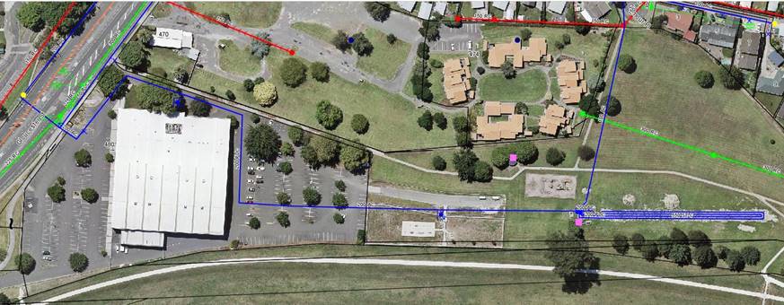
Summary
· The documents and reports, participation statistics and information from Hawke’s Bay’s regional indoor sports organisations indicate that there is an unmet demand for court space.
· Demand is driven exclusively from organised sports.
· Pettigrew Green Arena have developed plans to expand its current facility to meet this demand.
· Napier City Council has committed funding of $4.1 million to this project (or another indoor sports solution).
· There are some planned developments in Hawke’s Bay to help to meet the demand.
· There are some issues with the proposed PGA development that need to be worked through.
· RISEC have requested support from Napier City Council to progress this project.
· Should the project be unable to proceed, Napier City Council will need to investigate alternative solutions to meet the identified need.
10.3 Issues
· Validating actual demand to ensure that investment is targeted
· Potential obstacles with the PGA expansion cannot be overcome
10.4 Significance and Engagement
N/A
10.5 Implications
Financial
· Investment of $4.1m
· Impact on ongoing operational funding support for a larger facility
At this stage the proposal involves the formation of a working group only to investigate options and make recommendations. These recommendations depending on their nature may have a financial requirement and will need to come back to Council for consideration of any Council investment.
Social & Policy
N/A
Risk
Demand risk:
· The projected demand does not eventuate from organised sports, impacting the financial projections and requiring increases in operational funding
· Additional facilities being constructed
· Change in demand due to RSO capabilities
· Change in demand due to customer drivers
· Mitigated to an extent by alternative activities
Cost escalation:
· Construction escalation was estimated to slow at the end of 2018 and flatten at the start of 2019. This has not happened and the costs are continuing to rise in the industry at three per cent per year.
Programme risk:
· Constraints with land ownership or permissions stop project
· Constraints with resource consent conditions stop project
· Accountability and role clarity between RISEC and any project support provided
· Potential obstacles with the PGA expansion cannot be overcome
Functionality risk:
· Changes in the nature of demand leave - possibility of repurposing facility for different activities as demand changes
10.6 Options
The options available to Council are as follows:
a. Approve the formation of an Indoor Sports Working Group to facilitate the progression of the investigation and development of indoor court facilities
b. Approve the formation of the Indoor Sports Working Group, with amendments to the scope and terms
c. Do not approve the formation of the Indoor Sports Working Group.
10.7 Development of Preferred Option
If the formation of the Indoor Sports Working group is approved, the next steps are to:
· Establish a terms of reference for the working group
The working group is recommended to include:
o Councillor Keith Price
o Councillor Graeme Taylor
o Councillor Greg Mawson
o Jon Kingsford, Director of Infrastructure
o Glenn Lucas, Manager Sports and Recreation
o Dan Rodden, Manager PGA (to be confirmed as to whether a working group member or key stakeholder)
o Ryan Hambleton, Sport Hawke’s Bay (to be confirmed as to whether a working group member or key stakeholder)
· This terms of reference will be set by the Group but will include as a minimum:
o Purpose
o Objectives
o Principles
o Membership
o Role of members
o Term
o Meetings
o Communication protocols
o Project stages
· Questions that the working group will need to address include:
o What is the problem that we are trying to address?
o What are the barriers facing the expansion of PGA?
o How significant are they and are they surmountable?
o If yes, what is required to support this project?
o If no, what other options are there to solve the problem?
· Critical stakeholders for the group will be:
o EIT
o Hawke’s Bay Regional Council
o Indoor sports groups and associations
o Hawke’s Bay Sports Council
o Hastings District Council
· Project stages (to be confirmed once group established) include:
o Formation of Indoor Sports Working Group
o Complete and agree terms of reference
o Understand demand
o Assess PGA model – does this deliver?
o Recommend an option or options to proceed
o Recommendations to Council for approval.
a National Facilities Strategy for Indoor Sports (2013) – Aurecon (Under Separate Cover) ⇨
b Indoor court need and site assessment: Global Leisure Group (Under Separate Cover) ⇨
c Hawke's Bay Regional Sports Facilities Plan (Under Separate Cover) ⇨
d Basketball New Zealand Indoor Facilities Guide (Under Separate Cover) ⇨
e Pettigrew Green Arena Detailed Business Case (Under Separate Cover) ⇨
f Pettigrew Green Arena extension proposal (Under Separate Cover) ⇨
g Pettigrew Green Arena Concept and Locality Plan (Under Separate Cover) ⇨
Extraordinary Meeting of Council - 09 April 2020 - Open Agenda Item 11
11. LEASE OF RESERVE - THE SCOUT ASSOCIATION OF NEW ZEALAND
|
Type of Report: |
Legal |
|
Legal Reference: |
Reserves Act 1977 |
|
Document ID: |
901760 |
|
Reporting Officer/s & Unit: |
Bryan Faulknor, Manager Property Jenny Martin, Property and Facilities Officer |
11.1 Purpose of Report
To obtain Council approval to grant a new ground lease the Scout Association of New Zealand at Meeanee Quay for ten years with one right of renewal.
|
That Council: a. Agree to enter into a ground lease pursuant to Section 61(2A) of the Reserves Act 1977 with the Scout Association of New Zealand for the land at 808B Meeanee Quay, Westshore for ten years with one right of renewal.
|
|
That Council resolve that the officer’s recommendation be adopted. |
11.2 Background Summary
The Meeanee Quay Reserve is a Local Purpose Maritime Reserve vested in the Council pursuant to the Reserves Act 1977. The property at 808B Meeanee Quay forms part of that Reserve.
The Westshore Sea Scouts, under the parent body the Scout Association of New Zealand are incumbent tenants of the Reserve. The Sea Scouts have been a tenant of the land for a number of years. The previous ground lease has expired and a new lease needs to be entered into to provide certainty and clarity for both the Council and the Scout Association.
The lease area is shown outlined in red on the attached aerial map.
The terms and conditions of the proposed lease are as per Council’s standard terms for leases of Reserve land to community groups. The ground rental is calculated according to the method by which Council sets its rentals for community organisations on Reserve land and is reviewed annually.
11.3 Issues
There are no issues
11.4 Significance and Engagement
Not applicable
11.5 Implications
Financial
The annual rental will be calculated in accordance with the standard formula used by Council to calculate ground rental to community groups.
Social & Policy
The Sea Scouts provide a community activity for the youth of Napier.
Risk
There is no risk to Council.
11.6 Options
The options available to Council are as follows:
a. To enter into a new ground lease with the Scout Association of New Zealand at 808B Meeanee Quay for ten years with one right of renewal.
b. To not enter into a new ground lease with the Scout Association of New Zealand at 808B Meeanee Quay for ten years with one right of renewal.
11.7 Development of Preferred Option
Option (a) is preferable to provide legal tenure and certainty for Council and the Association.
a Aerial map of 808B Meeanee Quay ⇩
Extraordinary Meeting of Council - 09 April 2020 - Open Agenda Item 12
12. Civil Defence Emergency Management Group Joint Committee Draft Minutes - 23 March 2020
|
Type of Report: |
Information |
|
Legal Reference: |
N/A |
|
Document ID: |
916587 |
|
Reporting Officer/s & Unit: |
Cheree Ball, Governance Advisor |
12.1 Purpose of Report
To receive the draft minutes of the Civil Defence Emergency Management Group Joint Committee meeting held on 23 March 2020.
|
That Council: a. Receive the draft minutes of the Civil Defence Emergency Management Group Joint Committee meeting held on 23 March 2020.
|
|
That the Council resolve that the officer’s recommendation be adopted.
|
12.2 Background Summary
The Civil Defence Emergency Management Group Joint Committee met on 23 March 2020 and the draft minutes of this meeting are attached for Council’s information.
a CDEM Group Joint Committee Draft Minutes - 23 March 2020 ⇩
Extraordinary Meeting of Council - 09 April 2020 - Open Agenda
That the public be excluded from the following parts of the proceedings of this meeting, namely:
Agenda Items
1. Funding approval
The general subject of each matter to be considered while the public was excluded, the reasons for passing this resolution in relation to each matter, and the specific grounds under Section 48(1) of the Local Government Official Information and Meetings Act 1987 for the passing of this resolution were as follows:
|
General subject of each matter to be considered. |
Reason for passing this resolution in relation to each matter. That the public conduct of the whole or the relevant part of the proceedings of the meeting would be likely to result in the disclosure of information where the withholding of the information is necessary to: |
Ground(s) under section 48(1) to the passing of this resolution. 48(1)(a) That the public conduct of the whole or the relevant part of the proceedings of the meeting would be likely to result in the disclosure of information for which good reason for withholding would exist: |
|
Agenda Items |
||
|
1. Funding approval |
7(2)(i) Enable the local authority to carry on, without prejudice or disadvantage, negotiations (including commercial and industrial negotiations) |
48(1)A That the public conduct
of the whole or the relevant part of the proceedings of the meeting would be
likely to result in the disclosure of information for which good reason for
withholding would exist: |